- Micklefield
-
Coordinates: 53°47′42″N 1°19′37″W / 53.795°N 1.327°W
For other uses, see Micklefield (disambiguation).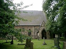 St Mary the Virgin, the parish church of Micklefield.
Micklefield is a village and civil parish east of Leeds, West Yorkshire, England. It neighbours Garforth, Aberford and Brotherton and is close to the A1 Motorway. It is in the City of Leeds metropolitan borough. It has a population of 1,852.[1]
Contents
Geography
The village is typical of Yorkshire's former coal mining communities with its mix of local authority and private houses. The village has undergone a rapid expansion in recent years with former commercial premises being demolished to make way for new private housing. The police house, fire station, community centre and local miner's welfare club have all closed leaving the village with one public house, the Blands Arms, and two local convenience stores, in addition to a stretch of land known locally as the Mickie rec" (recreation ground) which contains a football pitch, cricket pitch and two bowling greens.The "Rec" was owned and operated by the Coal Board before the closure of the local pit in 1984.
The 1½ mile £460,000 Micklefield Bypass opened in 1960. It has since been replaced by the A1(M) in 2005. Close to the west is the A656 Roman Ridge.
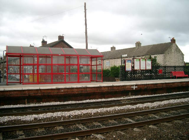
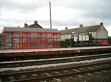 Micklefield Station
It does retain its railway station, located approximately midway between Leeds to the west and York/Selby to the east. In June 2006 it won the award for "best kept railway station" in all of Yorkshire, after making huge strides in the refurbishment of the station. There are also proposals for a new station at Micklefield called East Leeds Parkway. This station would house a park and ride scheme with space for 500 cars. This station would be sited close to Micklefield and, if approved, would open in around 2012.
Through the 1970s and 1980s Micklefield earned itself a sometimes poor reputation locally as a result of the sizeable local authority housing estate (council houses) and policies then employed by Leeds City Council that tended to locate families and relatives living in pool housing in close proximity to one another rather than dispersed across the metropolitan district.
History
Old and New Micklefield
Micklefield is a village of two halves. One road - the Great North Road or "the old A1" - links the two with a distinctive S bend surrounded fields giving a fair indication of when moving from one half to the other.
The southern part is known as "The Old Village". It contains the railway station, landfill site, industrial park and allotments. Housing consists mainly of late 19th century/early 20th century terraced cottages built for miners, some larger pre-war semi-detached houses, and the Garden Village housing estate. In recent years, new flats have been built next to Pit Lane. The old fire station is used as a community centre. Nearby is a sandwich bar, and a small independent shop.
The northerly part of the village (Old Micklefield) has fewer visible ties to the village's industrial past, and contains most of the village amenities, including the church, school, pub, farm shop, general stores (formerly the post office) and surgery. The Churchville housing estate consists of semi-detached houses, retirement bungalows and terraces, but is bordered by large detached houses, character properties and modern town houses.
The Hook Moor Wind Farm proposals have also polarised village opinion along north/south lines, with some Old Micklefield residents accusing New Micklefielders who support the plans, of "Schadenfreude". To which, the standard reply is, if the plans were situated in New Micklefield, nobody would be against the proposals at all. The parish church is dedicated to St Mary the Virgin and is in Old Micklefield.
Mining history
The village served the Peckfield Colliery, which served the “superpit” field of Selby, North Yorkshire. It produced high volatile bituminous coal in the Westphalian Coal Measures.
In first half of the 20th century, two seams of coal were worked. The first was the Beeston seam at 170–180 yards depth; the second was a deeper Blackbed seam at 210–220 yards.
Up to the 1980s the pit was served by a 2' 6" gauge rail link which transported coal from Ledston Luck Mine to the south, from where the coal could be shipped via the mainline rail.
The pit came into operation in the 1870s and was the location of an enormous explosion on 30 April 1896, in which 65 of the 300 workers (men and boys) died. Twenty died from the explosion, the rest from afterdamp. Only two of the 25 pit ponies survived the disaster. Ninety children were rendered fatherless in the disaster, and plaques in the village school, church and pub are dedicated to their loss.
Sport
Football
Micklefield AFC are an amateur football team. They play their home fixtures in the village recreation ground. The pitch consists of 1 small covered terraced stand and a metal barrier runs round the perimeter to prevent encroachment. The club also boasts modest changing and showering facilities
Micklefield AFC was established in 1953, although it wasn't until the late 1960s that it rose to prominence. The club enjoyed great success throughout the 1970s and 80's, winning several amateur leagues and cups. The 1990s saw the retirement of many key players and subsequently the clubs form on the pitch deteriorated. In 2002 the club reached its first final since the glory days of the 1970s and 1980s only to lose in injury time. In 2004 the club folded due to a lack of players. The club was revived in 2007. The emergence of young players from within the village suggests the club has a bright future although they are never likely to attract the same crowds as in the glory era.
http://www.micklefieldtownfc.co.uk/
2010 Micklefield Town FC reached the county cup semi final and play at County HQ fleet lane on the 26th March and will hopefully bring home the County Cup to micklefield once more
Cricket
There is a cricket pitch in the rec. Micklefield do not have a team but the pitch is occasionally used by Kippax Welfare and Aberford.
School
Since records began Micklefield has been noted to have three primary schools, with one of them tragically burning down at the bottom end of the village, in the late 1970s. During the period when Micklefield had no school, students attended primary schools in Sherburn-in-Elmet for a short period.[2] During this period the current school was built. It is situated in the middle of the village.Micklefield CofE Primary School was rebuilt on the site of the old school which burnt down until the mid to late 80's when it was relocated to the middle of the village besides the local public house,the Bland's Arms.
Broadband Internet Access
Due to the distance to the telephone exchange at nearby Garforth and the underlying TPON infrastructure, Micklefield was dependent on copper overlay providing broadband speeds well below the UK average until summer 2011. A local community broadband initiative based on fixed wireless technology was started in late 2009 to address the issue. This has now evolved into a commercial solution offered by LN Communications. More details about which can be found at the associated website. Fibre optic broadband is now available.
Hook Moor Wind Farm
Proposals brought by Banks Renewables Ltd, to build a wind farm on Hook Moor, to the east (and slightly north) of the village but separated from it by the A1(M) motorway section, have provoked strong emotions and divisions within the community.
Opponents to the scheme are represented by the Hook Moor Wind Farm Action Group, while no body exists to lobby in favour of the plan. HMWFAG and the local parish council will reserve rights not to print favourable reports about the wind farm, even though some villagers have sent letters of support. Although no poll has taken place to gauge the views of the village as a whole, the HMWFAG still claims to represent a significant majority and has robustly campaigned through the local media and its own website. The local parish council are keen to fund the HMWFAG for its campaign, however far more reserved for those who wish to support the proposals.
A public exhibition held by Banks in July 2007 resulted in 49 comments, 31 expressing negative viewpoints.
Numerous arguments against the wind farm have been aired publicly, for example:
- TV interference caused by the turbines will ruin reception. The basis for this objection is unclear since Micklefield lies between the transmitter (Emley Moor) and Hook Moor. Banks have asserted that any impact will be rectified at their expense.
- Flicker caused by shadows will cause a distraction, although how this might arise is unclear, as shadows caused by sunlight would extend away from the village, not toward it.
- "Noise". One leaflet produced by HMWFAG compared the potential noise of a wind farm, to the disruptive noise caused by living near a railway and less than 50m from the A1. As the York-Leeds railway runs through New Micklefield this was perceived by some residents of New Micklefield, to be a crass remark.
References
External links
- "The Ancient Parish of Sherburn in Elmet". GENUKI. http://www.genuki.org.uk/big/eng/YKS/WRY/Sherburninelmet/index.html. Retrieved 2007-10-29. Micklefield was in this parish
- "Leeds City Council housing department". http://www.leeds.gov.uk/Housing.aspx.
- "Micklefield reunited with Brotherton". BBC News. 2005-04-04. http://news.bbc.co.uk/1/hi/england/north_yorkshire/4402009.stm. Retrieved 2010-01-05.
- "Hook Moor Wind Farm Action Group". http://www.hookmoorwindfarm.org.uk.
- "Banks Developments". http://www.banksdevelopments.com.
Categories:- Places in Leeds
- Civil parishes in West Yorkshire

Wikimedia Foundation. 2010.