- Nueva Esparta
-
For the municipality in El Salvador, see Nueva Esparta, El Salvador.
Nueva Esparta State
Estado Nueva Esparta— State — 
Flag
Coat of armsAnthem: Nueva Esparta State Anthem Location within Venezuela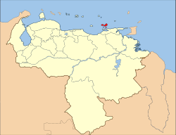
Country  Venezuela
Created 1909 Capital La Asunción Government – Governor Morel Rodríguez (2004–present) Area – Total 1,150 km2 (444 sq mi) Area rank 23rd 0.12% of Venezuela Population (2007 est.) – Total 436,900 – Rank 20th 1.68% of Venezuela Time zone UTC-04:30 ISO 3166 code VE-O Emblematic tree Guayacán (Guaiacum officinale) Website guaiqueri.net Nueva Esparta State (Spanish: Estado Nueva Esparta, IPA: [esˈtaðo ˈnweβa esˈparta]; 'New Sparta') is one of the 23 states of Venezuela. It comprises Margarita Island, Coche, and the largely uninhabited Cubagua.
The state is the smallest one in area, and is located off the northeast Caribbean coast of Venezuela. It is the only insular state of Venuezuela. Its name comes from the heroism shown by its inhabitants during the Venezuelan War of Independence, deemed similar to that of the Spartan soldiers of Ancient Greece. The main island of Margarita alone has an area of 934 km². In 1909 the state was constituted and in 1947 the island of Cubagua was added. Its capital city is La Asunción, but the main urban center is Porlamar. Other important towns are Juan Griego, Pampatar (home of the Port Authority), Punta de Piedras, San Juan Bautista, Las Guevaras, Las Hernández, Villa Rosa, Bella Vista (Margarita), El Valle del Espíritu Santo.
Nueva Esparta was also the name of a Destroyer Class, it was the leader of 1st Destroyer Division, a British built for Venezuela naval forces in the 50's.
Contents
History
Founded in 1525, the Province of Margarita was the oldest of those that in 1777 formed the Post of Captain-General of Venezuela. It was dependent on the Royal Audience of Santo Domingo until 1739, when it was annexed to the Viceroyalty of New Granada (Virreinato de Nueva Granada). In 1821, when the Greater Colombia was created, the Province of Margarita was integrated to the Orinoco Department, along with other regions. When the Republic of Venezuela arose in 1830, it was one of its 13 original provinces. In 1864, when the country was divided into 20 states and a Federal District, Margarita took the name of State of New Sparta. In 1881 its status was changed to be a mere section of the Greater Guzmán Blanco State (Called Miranda from 1889 to 1898). In 1901, two years after the autonomy of the states was restituted, it retook the name of New Sparta, but again lost it between 1904 and 1909, period in which it was included in the Federal District as "Eastern Section". Finally, in 1909 it recovered the condition of a State, and in 1948 it annexed the island of Cubagua territory.
Table of Municipalities
Municipality Area
km²Population
Census
2001-10-21Municipal
capitalMunicipal Division of Nueva Esparta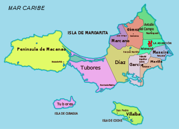
Antolín del Campo 66 20,325 La Plaza de Paraguachí Arismendi 55 23,097 La Asunción Díaz 141 47,257 Parroquia San Juan Bautista García 89 45,606 El Valle del Espíritu Santo Gómez 91 30,237 Santa Ana Maneiro 38 35,400 Pampatar Marcano 43 28,256 Juan Griego Mariño 39 84,534 Porlamar Macanao1) 320 20,935 Boca del Río Tubores2) 207 29,962 Punta de Piedras Villalba3) 61 8,242 San Pedro de Coche Nueva Esparta 1,150 373.851 La Asunción 1) the western peninsula 2) including Cubagua Island 3) coincident with Coche Island 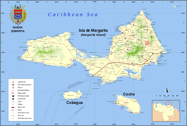 Detailed map of Nueva Esparta
See also
External links
- http://www.gobernaciondenuevaesparta.com/ State government page.[dead link]
Capital District 
States Dependencies Regions Claimed Categories:- Nueva Esparta
- States of Venezuela
- States and territories established in 1909
- Venezuela geography stubs


Wikimedia Foundation. 2010.