- Bolívar (state)
-
For the historic state in what is now Colombia, see Sovereign State of Bolívar.
Bolívar State
Estado Bolívar— State — 
Flag
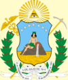
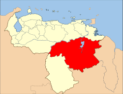
Coat of armsAnthem: Bolívar State Anthem Location within Venezuela Country  Venezuela
Created 1901 Capital Ciudad Bolívar Government – Governor Francisco Rangel (2004–present) Area – Total 238,000 km2 (91,892.3 sq mi) Area rank 1st 26.24% of Venezuela Population (June 30, 2010) – Total 1,620,359 – Rank 7th 5.62% of Venezuela Time zone UTC-04:30 ISO 3166 code VE-F Emblematic tree Sarrapia (Diphysa punctata) Website www.e-bolivar.gob.ve Bolívar State (Spanish: Estado Bolívar, IPA: [esˈtaðo βoˈliβar]), is one of the 23 states (estados) into which Venezuela is divided. The state capital city is Ciudad Bolívar. Bolívar State covers a total surface area of 238,000 km² and in June 30, 2010 had an estimated population of 1,620,359.
Places of interest
- Historical Zone of Ciudad Bolívar
- Canaima National Park
- Angel Falls
- Roraima
- La Gran Sabana (Spanish: Great Plains)
- Sarisariñama
- Kavanayen
- Santa Elena de Uairen
- Cerro Bolivar, a large iron mine
- Caroni River
Municipalities
- Caroní (Ciudad Guayana)
- Cedeño (Caicara del Orinoco)
- El Callao (El Callao)
- Gran Sabana (Santa Elena de Uairén)
- Heres (Ciudad Bolívar)
- Padre Pedro Chien (El Palmar)
- Piar (Upata)
- Raúl Leoni (Ciudad Piar)
- Roscio (Guasipati)
- Sifontes (Tumeremo)
- Sucre (Maripa)
See also
Capital District 
States Dependencies Regions Claimed Categories:- Bolívar (state)
- States of Venezuela
- States and territories established in 1901
Wikimedia Foundation. 2010.

