- Crystal Springs Reservoir
-
Crystal Springs Reservoir 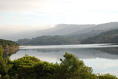
Lower Crystal Springs Reservoir as viewed from the Sawyer Camp Trail Location Santa Cruz Mountains
San Mateo County, CaliforniaCoordinates Lower reservoir
37°31′41″N 122°21′54″W / 37.5280°N 122.3650°WCoordinates: 37°31′41″N 122°21′54″W / 37.5280°N 122.3650°W
Upper reservoir
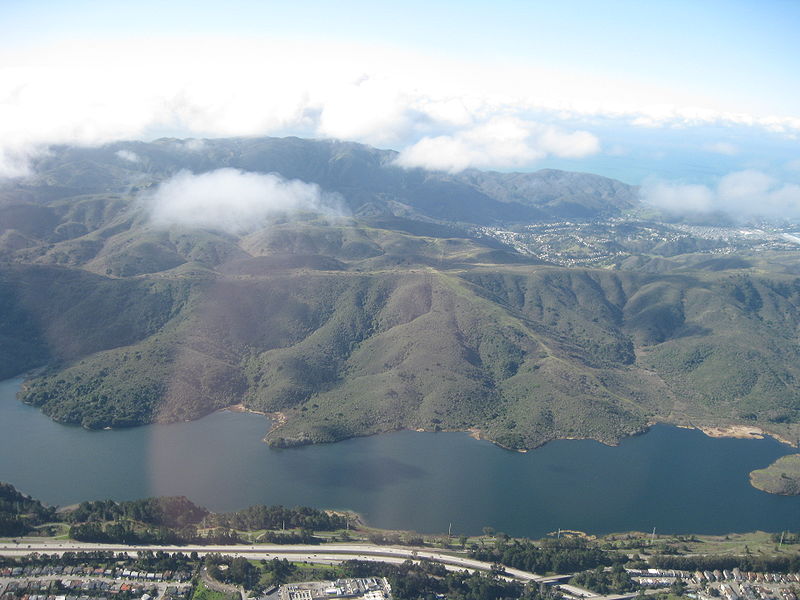
37°29′57″N 122°20′20″W / 37.4993°N 122.3389°WLake type Reservoir Primary inflows San Mateo Creek, San Andreas Creek, Adobe Gulch, Laguna Creek Primary outflows San Mateo Creek Catchment area 29.4 sq mi (76 km2) Basin countries United States Surface area 1,323 acres (535 ha) Water volume 57,910 acre·ft (71,430,000 m3) Surface elevation 85 m (279 ft) References U.S. Geological Survey Geographic Names Information System: Crystal Springs Reservoir Crystal Springs Reservoir is a pair of artificial lakes located in the northern Santa Cruz Mountains of San Mateo County, California situated in the rift valley created by the San Andreas Fault just to the west of the cities of San Mateo and Hillsborough, and I-280. The lakes are part of the San Mateo Creek watershed.
Contents
History
The original name of the southern or Upper Crystal Springs Reservoir was Laguna Grande, which has a California Historical Marker ("NO. 94 PORTOLA EXPEDITION CAMP - The Portolà expedition of 1769 camped on November 5 at a 'laguna grande' which today is covered by the Upper Crystal Springs Lake.") located at Crystal Springs Dam, on Skyline Boulevard, 0.1 mi south of Crystal Springs Road.[1][2] The Laguna Grande place name is also shown on the 1840's diseño del Rancho Cañada de Raymundo[3] and an 1856 plat of the Rancho de las Pulgas.[4][5] Lower Crystal Springs Reservoir now covers the town of Crystal Springs which grew up around a little resort town of the same name, located just northwest of the present dam.[6][7]
The two Crystal Springs lakes and San Andreas Lake used to be known as Spring Valley Lakes for the Spring Valley Water Company which owned them. The Spring Valley Water Company named the lakes, the Spring Valley Lakes, after the company. The original Spring Valley was between Mason and Taylor Streets, and Washington and Broadway Streets in San Francisco, where the water company started. When the company went south for more water, the Spring Valley name was carried south too.[8]
Description

The entire reservoir consists of two different reservoir lakes.
The southern lake, Upper Crystal Springs Reservoir, was formed when a tributary, Laguna Creek (or Lake Creek), which joined Laguna Grande at the south end, was submerged by construction of an earthen dam (this was the first Crystal Springs Dam) in 1877.[9][6] The old earthen dam became a causeway between Upper and Lower Crystal Springs Reservoirs when the latter was formed by Herman Schussler's 150 foot tall concrete Crystal Springs Dam, which dammed up San Mateo Creek to form the lower (northern) reservoir in 1888.[10] The causeway is now crossed by Highway 92. Laguna Creek flows north through the Filoli estate and has tributaries that descend from the western slope of Edgewood County Park and the eastern slope of the Santa Cruz Mountains.[9] In addition to Laguna Creek, Upper Crystal Springs Reservoir is fed by Adobe Gulch which descends from Cahill Ridge south of and parallel to Highway 92 into a wetland marsh then joins the reservoir at Adobe Point.[11]
The northern reservoir, Lower Crystal Springs Reservoir, is fed by San Mateo Creek and San Andreas Creek at its north end. It also receives water from Upper Crystal Springs Reservoir via tunnels beneath Highway 92. Below Crystal Springs Dam, lower San Mateo Creek receives limited flows from Lower Crystal Springs Reservoir and descends to the Bay.[12]
In 1924, culverts were built through Upper Crystal Springs Dam to hydraulically link Upper and Lower Crystal Springs Reservoirs.[13]
Part of the water in the reservoirs comes from local precipitation and the rest is piped in from the Hetch Hetchy Reservoir in Yosemite National Park, as well as the PIlarcitos Creek watershed and Alameda Creek watershed.[13] The entire reservoir was built and owned by a private company, in the form of the Spring Valley Water Company, and eventually was deeded under the ownership and protection of the city of San Francisco. This local protection has ensured the survival of important species in the area, and a set of trails in Crystal Springs Park allows many to enjoy the scenic beauty of the reservoir and the local wildlife. There are giant rainbow trout and bass in the lake. Due to decisions by the San Francisco Public Utilities Commission (SFPUC), Crystal Springs Reservoir is not open to public.
Flora and fauna
A considerable biodiversity of flora and fauna exist in the vicinity of the reservoir, which is located within the California Floristic Province. Among these species are a number of rare and endangered species including Acanthomintha duttonii or San Mateo thornmint, Hesperolinon congestum (Marin Dwarf Flax) and Eriophyllum latilobum or San Mateo Woolly Sunflower.[14]
See also
- Hetch Hetchy Aqueduct
- List of lakes in the San Francisco Bay Area
- Filoli - a historic estate on the reservoir
References
- ^ Spring Valley Water Company (1922). San Francisco Water, Volumes 1-8. University of California. p. 12. http://books.google.com/books?id=ncUVAQAAIAAJ&pg=RA1-PA92&lpg=RA1-PA92&dq=%22laguna+grande%22+%22san+mateo%22&source=bl&ots=ZrrKIGvt57&sig=pnypZ3OJFtj9LRIIAjS7NDFRXGY&hl=en&ei=7GaeTuqJOfLJiQKTx-nKCQ&sa=X&oi=book_result&ct=result&resnum=7&ved=0CEsQ6AEwBg#v=onepage&q=%22laguna%20grande%22%20%22san%20mateo%22&f=false. Retrieved 2011-10-18.
- ^ "California Historical Landmarks". California State Parks Office of Historic Preservation. http://www.parks.ca.gov/default.asp?page_id=21520. Retrieved 2011-10-09.
- ^ "Diseño del Rancho Cañada de Raymundo". Calisphere, University of California. http://content.cdlib.org/ark:/13030/hb0z09n6g2/?&brand=oac. Retrieved 2011-10-09.
- ^ Erwin Gustav Gudde (1974). California Place Names. University of California Press. p. C-261. http://books.google.com/books?id=M-22djGNuhwC&pg=SL3-PA261&lpg=SL3-PA261&dq=gudde+raimundo&source=bl&ots=-LJH-BRRJR&sig=mFJNYGnq5XoxLpJhryD18WQvAXU&hl=en&ei=dniSTvXCLvLWiAL17JzNCA&sa=X&oi=book_result&ct=result&resnum=1&ved=0CBoQ6AEwAA#v=onepage&q&f=false. Retrieved 2011-10-09.
- ^ The Bancroft Library, University of California, Berkeley (1856). Diseño del Rancho de las Pulgas : San Mateo Co., Calif. (Map). http://content.cdlib.org/ark:/13030/hb3t1nb14h/?docId=hb3t1nb14h&layout=printable-details. Retrieved 2011-10-30.
- ^ a b David L. Durham (1998). California's geographic names: a gazetteer of historic and modern names of the state. Quill Driver Books. p. 658. ISBN 9781884995149. http://books.google.com/books?id=Yfa0hmE7yocC&pg=PA650&lpg=PA650&dq=laguna+creek+san+mateo&source=bl&ots=nGR2LVZ1cH&sig=JCiTJkLn8M2IvRPpBLkRtINBycw&hl=en&ei=pSc9TLrtFoH0swPJ48naCg&sa=X&oi=book_result&ct=result&resnum=9&ved=0CDYQ6AEwCA#v=onepage&q=lower%20crystal%20springs%20reservoir&f=false. Retrieved 2010-07-13.
- ^ Erwin G. Gudde, William Bright (2004). California Place Names: The Origin and Etymology of Current Geographical Names. University of California Press. p. 97. ISBN 9780520242173. http://books.google.com/books?id=Kqwt5RlMVBoC&pg=PA200&lpg=PA200&dq=lagunas+grande+san+mateo&source=bl&ots=3tnghagXqS&sig=LWbvKNrigMj8AzBK0rOVqahhDMc&hl=en&ei=U3F1TuLnKsbSiAK4-JyzAg&sa=X&oi=book_result&ct=result&resnum=1&ved=0CBoQ6AEwAA#v=onepage&q=crystal%20springs&f=false. Retrieved 2011-09-17.
- ^ Erwin G. Gudde, William Bright (2004). California Place Names: The Origin and Etymology of Current Geographical Names. University of California Press. p. 372. ISBN 9780520242173. http://books.google.com/books?id=Kqwt5RlMVBoC&q=spring+valley+#v=snippet&q=spring%20valley&f=false. Retrieved 2011-10-30.
- ^ a b Alan Hynding (1982). From Frontier to Suburb, The Story of the San Francisco Peninsula. Belmont, California: Star Publishing Company. p. 75. ISBN 9780898630565.
- ^ Ferol Egan (1998). Last bonanza kings: the Bourns of San Francisco. University of Nevada Press. p. 167. ISBN 9780874173192. http://books.google.com/books?id=f6kl1_2c1sQC&pg=PA167&lpg=PA167&dq=bourn+%22laguna+creek%22&source=bl&ots=k2Pq3aFB4I&sig=L2GNRZMszSfMl2q9YyQkDXdWoug&hl=en&ei=uhGVTsWqOe3diALOvtXsBA&sa=X&oi=book_result&ct=result&resnum=2&ved=0CB4Q6AEwAQ#v=onepage&q=%22laguna%20creek%22%20bourn&f=false. Retrieved 2011-10-11.
- ^ "Adobe Gulch". Geographic Names Information System, U.S. Geological Survey. http://geonames.usgs.gov/pls/gnispublic/f?p=gnispq:3:::NO::P3_FID:217992.
- ^ Department of Water Resources (2009). "Station Meta Data: Lower Crystal Springs Dam (CRY)". California Data Exchange Center. State of California. http://cdec.water.ca.gov/cgi-progs/profile?s=CRY&type=dam. Retrieved 2009-04-01.
- ^ a b San Francisco Peninsula Streams and Reservoirs, in WSIP Water Supply and System Operations – Setting and Impacts (Report). p. 5.5.1-5. http://www.sf-planning.org/Modules/ShowDocument.aspx?documentid=7999. Retrieved 2011-10-30.
- ^ Miles, Scott R; Goudey, Charles B. (1997). "Subsection 261Ag Leeward Hills". Ecological Subregions of California: Section and Subsection Descriptions. R5-EM-TP, 005. San Francisco: USDA Forest Service, Pacific Southwest Region. OCLC 38434607. http://www.fs.fed.us/r5/projects/ecoregions/261ag.htm.
External links
Categories:- Landforms of San Mateo County, California
- Reservoirs in the San Francisco Bay Area
- Hetch Hetchy Project
- Buildings and structures in San Mateo County, California

Wikimedia Foundation. 2010.