- Montclair State University (NJT station)
-
Montclair State University Station at Little Falls 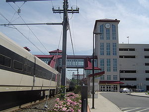
Montclair State University station parking deckStation statistics Coordinates 40°52′10″N 74°11′51″W / 40.8695°N 74.1975°WCoordinates: 40°52′10″N 74°11′51″W / 40.8695°N 74.1975°W Lines Connections MSU campus shuttles Platforms 1 high level island platform Tracks 2 Parking 1530 spots Other information Opened October 20, 2004[1] Electrified yes Accessible 
Owned by New Jersey Transit Fare zone 6 Traffic Passengers (2010) 525 (average weekday)  13.71%
Services Preceding station NJ Transit Rail Following station (closed)toward HackettstownMontclair-Boonton Line toward HackettstownMontclair-Boonton Line Montclair-Boonton Line Legend

Hackettstown 
Mount Olive 
Netcong Lake Hopatcong Mount Arlington Dover Denville 
Morristown Line rejoins Mountain Lakes Boonton Towaco Lincoln Park Mountain View Wayne-Route 23 Little Falls 
diesel service only 
Montclair State University Montclair Heights Mountain Avenue Upper Montclair Watchung Avenue Walnut Street Bay Street Glen Ridge Bloomfield Watsessing Avenue 
Morristown & Gladstone lines diverge 
Newark Broad Street 
Passaic River 

Connections to NEC Hackensack River 

Secaucus Junction 

Hoboken 
Hudson R., N.Y./N.J. border 
New York Penn Station Montclair State University Station at Little Falls is a New Jersey Transit rail station in the Great Notch area of Little Falls, New Jersey on the Montclair-Boonton Line.[2] It serves nearby Montclair State University as well as serving as a transfer station for trains on the line, and is located on Clove Road near Route 46. This station was opened on October 20, 2004[1] and was built at a cost of US$26 million,[3] after the Montclair Connection was finished. Before opening it was used as a transfer platform. There is no weekend service at the station. On weekdays, every train on the Montclair-Boonton Line stops here. Midtown Direct service to Penn Station terminates here, as the line west of the nearby yard is not electrified. The station is a major transfer point for riders because many trains terminate here, it is the first station on the line with service to New York Penn Station, and it is the first local stop of express trains. The station is a sheltered, two-tracked island platform with an elevated walkway over the tracks connecting it to the parking deck and the college campus. The station is equipped with ticket machines and monitors displaying arrivals and departures. It is accessible as the platform is fully elevated and elevators are available in addition to stairs. The station was intended to be a Park-and-Ride, near a highway and with a large parking deck.
Contents
Service
Although the Montclair-Boonton Line recently added weekend service, Montclair State University is not served on weekends as Bay Street is the weekend terminus for trains to and from Hoboken. [4]
Gallery
-
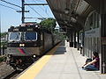
The Montclair State University Station platform has screens which relate the departure and arrival times and destinations of trains.
-
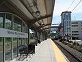
The parking garage as seen from the platform.
References
- ^ a b "MONTCLAIR STATE UNIVERSITY STATION AND 1,500-SPOT PARKING DECK OFFICIALLY OPENS: “See More Spots” marketing campaign begins". New Jersey Transit. October 20, 2004. http://www.njtransit.com/tm/tm_servlet.srv?hdnPageAction=PressReleaseTo&PRESS_RELEASE_ID=1526. Retrieved 2009-07-07.
- ^ "Station Information: Montclair State University". New Jersey Transit. http://www.njtransit.com/rg/rg_servlet.srv?hdnPageAction=TrainSchedulesFrom&selStation=38081. Retrieved 2009-07-07.
- ^ "NJ TRANSIT AWARDS CONTRACT FOR NEW TRAIN STATION AT MONTCLAIR STATE UNIVERSITY: $26 Million Project will Support New Direct Rail Service to New York". New Jersey Transit. June 12, 2002. http://www.njtransit.com/tm/tm_servlet.srv?hdnPageAction=PressReleaseTo&PRESS_RELEASE_ID=507. Retrieved 2009-07-07. "The NJ TRANSIT Board of Directors today awarded a $26 million contract to Prismatic Development Corporation of Plainfield, NJ, to design and build a new station, a 1,300-space parking facility and traffic improvements near Montclair State University (MSU) on the Boonton Line in Little Falls."
- ^ "Montclair-Booton Line Extends its Trail: MSU Not on the Stop List". The Montclarion (MSU newspaper). 2009-01-26. http://themontclarion.org/archives/1046. Retrieved 2010-01-18.
External links
Categories:- New Jersey Transit stations
- New Jersey railway station stubs
- Montclair, New Jersey
- Buildings and structures in Essex County, New Jersey
- Transportation in Essex County, New Jersey
-


Wikimedia Foundation. 2010.