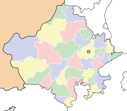
- Manohar Thana
-
Manohar Thana — city — Coordinates 24°14′15.94″N 76°48′7.24″E / 24.2377611°N 76.8020111°ECoordinates: 24°14′15.94″N 76°48′7.24″E / 24.2377611°N 76.8020111°E Country India State Rajasthan District(s) Jhalawar Population
• Density
(2001[update])
• 9,227 /km2 (23,898 /sq mi)
Time zone IST (UTC+05:30) Manohar Thana is a census town in Jhalawar district in the Indian state of Rajasthan.
Demographics
As of 2001[update] India census[1], Manohar Thana had a population of 9227. Males constitute 52% of the population and females 48%. Manohar Thana has an average literacy rate of 64%, higher than the national average of 59.5%: male literacy is 73%, and female literacy is 54%. In Manohar Thana, 18% of the population is under 6 years of age.
Successful Families
Manohar Thana has produced many successful business people and professional. Soni family and Chatter family has done specifically well globally with presence not only in Rajasthan (other cities like Kota) but also in the US, Europe and Middle East.
NGO List
Chandrashekhar Sahu president of Rajasthan Karunaa Foundation ADDRESS-Manohar Thana DIST-Jhalawar
References
- ^ "Census of India 2001: Data from the 2001 Census, including cities, villages and towns (Provisional)". Census Commission of India. Archived from the original on 2004-06-16. http://web.archive.org/web/20040616075334/http://www.censusindia.net/results/town.php?stad=A&state5=999. Retrieved 2008-11-01.
Jhalawar Aklera · Bakani · Bhawani Mandi · Jhalawar · Jhalrapatan · Kolvi Mandi Rajendra pura · Manohar Thana · Pirawa
Cities and towns
in other districtsAjmer · Alwar · Banswara · Baran · Barmer · Bharatpur · Bhilwara · Bikaner · Bundi · Chittorgarh · Churu · Dausa · Dholpur · Dungarpur · Hanumangarh · Jaipur · Jaisalmer · Jalore · Jhunjhunu · Jodhpur · Karauli · Kota · Nagaur · Pali · Pratapgarh · Rajsamand · Sawai Madhopur · Sikar · Sirohi · Sri Ganganagar · Tonk · Udaipur
Categories:- Cities and towns in Jhalawar district
- Rajasthan geography stubs
Wikimedia Foundation. 2010.


