- Mandelbaum Gate
-
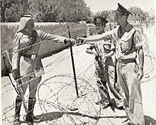
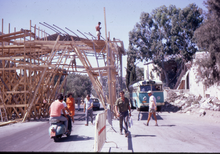
Mandelbaum Gate is a former checkpoint between Israeli and Jordanian sectors of Jerusalem, just north of the western edge of the Old City along the Green Line. The first checkpoint for the Hashemite Kingdom of Jordan/Israel Mixed Armistice Commission at the Mandelbaum Gate, from the close of the 1948 Arab-Israeli War in 1949 until August 1952, was moved from the Israeli side of the Gate to the Demilitarised Zone after the "Barrel Incident".[1] The second checkpoint existed until the 1967 Six-Day War.
The Gate was named after the Jewish merchant whose house stood where the Gate was built. Its location was determined by the entrance into the city of the Anglo-Jordanian Arab Legion following the withdrawal of British troops in May 1948. The Jordanians pushed Jewish defenders west and out of the Sheikh Jarrah area.
The Gate became a symbol of the divided status of the city, and to the Israelis of geographic isolation.
Tourists and United Nations personnel used the Gate to pass through the concrete and barbed wire barrier between the sectors, but Jordanian officials allowed only one-way passage for non-official traffic. The Jordanians permitted a once-weekly supply convoy from the Israeli sector to access Jewish property on Mount Scopus. The original sites of Hebrew University and Hadassah Hospital were technically under the protection of the United Nations, but despite the "Mount Scopus agreement" the institutions were not permitted to reopen.
The last person to pass through the Gate was the American journalist Flora Lewis, shortly before the outbreak of the Six Day War in June 1967. Jordanian forces joined the war on June 5, with a massive bombardment of the Israeli sector of the city.
Israeli forces captured the Jordanian part of Jerusalem within two days and soon tore down the Mandelbaum Gate. Only a historical marker remains.
References
- ^ Commander E H Hutchison USNR "Violent Truce: A Military Observer Looks at the Arab-Israeli Conflict 1951-1955" Chapter III The Barrel Incident p 20-30
See also
- The Mandelbaum Gate, a novel by Muriel Spark (1965)
- Mandelbaum
Coordinates: 31°47′14.94″N 35°13′36.53″E / 31.7874833°N 35.2268139°E
Categories:- Border crossings of divided cities
- Buildings and structures in Jerusalem
- Destroyed landmarks
- Gates
- 1949 establishments
- 1967 disestablishments
- Checkpoints
- Israel geography stubs
- Jewish history stubs
Wikimedia Foundation. 2010.


