- Cité (Paris Métro)
-
Cité
Paris Métro rapid transit station
Station statistics Address 2 Place Louis-Lépine
Paris, Île-de-FranceLines Platforms 2 side platforms Tracks 2 Other information Opened 10 December 1910 Code 0114 Owned by RATP Fare zone 1 Services Preceding station Paris Métro Following station toward Porte d'Orléans
 toward Porte de Clignancourt
Cité (French pronunciation: [site]) is a metro station on Line 4 of the Paris Métro in the 4th arrondissement of Paris.
Contents
Location
Cité station lies underneath the Île de la Cité, one of two islands on the Seine within the historical boundaries of Paris. In relation to the rest of the city, it lies within the 4th arrondissement, near Kilometre Zero, the official geographical and historical centre of Paris. The only station on the Île de la Cité, it lies near many famous landmarks, the most famous being the Cathedral of Notre Dame. To the west are the Sainte-Chapelle chapel and the Palace of Justice, while Notre Dame and the Hôtel-Dieu are to the east.
History
The station was opened on 10 December 1910 as part of the connecting section of the line under the Seine between Châtelet and Raspail.
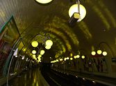
The station was renovated in 1991, and its lighting is green.
Station layout
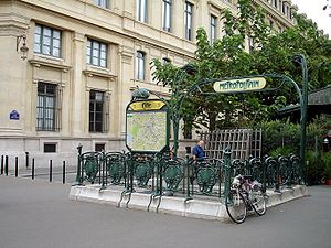
Similar to most Paris Métro stations, Cité utilises a side platform setup with two tracks. Unlike other stations on Line 4, the platforms are 110 m (361 ft) in length, longer than the 90-105m platforms at other stations. Access to Cité station is provided by a singular entrance at 2 Place Louis Lépine, the main square in the centre of the island.
Because of the station's depth, passengers must walk down to a mezzanine level, which contains ticket machines and fare control, and then another three flights of stairs before reaching platform level. As the Paris Métro runs inversely to normal railways in the rest of France, the eastern track is used by trains heading northbound to Porte de Clignancourt and the western southbound to Porte d'Orléans.
side platform 
 towards Porte de Clignancourt
 towards Porte d'Orléans
side platform Gallery
Coordinates: 48°51′19″N 2°20′47″E / 48.85528°N 2.34639°EThis article related to the Paris Métro is a stub. You can help Wikipedia by expanding it.


