- Mount Langley
-
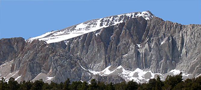
Mount Langley 
Mount Langley, looking northwest from Cottonwood LakesElevation 14,032 ft (4,277 m) [1][2] Prominence 1,165 ft (355 m) [2] Parent peak Mount Whitney[2] Listing Sierra Peaks Section[3] Location Location Inyo and Tulare counties, California, USA Range Sierra Nevada Coordinates 36°31′24″N 118°14′20″W / 36.5232685°N 118.2389774°WCoordinates: 36°31′24″N 118°14′20″W / 36.5232685°N 118.2389774°W[4] Topo map USGS Mount Langley Climbing First ascent Unknown, but prior to 1871[5] Easiest route Hike from New Army Pass on the south, class 1[6] Mount Langley is located on the crest of the Sierra Nevada, on the boundary between Inyo and Tulare counties, in eastern California in the southwestern United States. To the east is Owens Valley, and to the west is the Kern River Valley. It is the ninth highest peak in the state and the seventh highest in the Sierra. Mount Whitney, the highest peak in the contiguous United States, lies 4.8 miles (7.7 km) to the northwest. The National Geodetic Survey benchmark on the summit gives an elevation of 14,042 feet,[7] and this is the elevation shown on the Lone Pine 15" quadrangle published in 1946 and sited by many authors.
Contents
History
Today, the mountain is named after Samuel Pierpont Langley. In the early 1870s, it was confused with Mount Whitney by early climbers, and called by this name. When the mistake was realized, the peak was alternately called Mount Corcoran, Cirque Peak, or Sheep Mountain;[8] the former two names being later attached to other mountains. But its current name became established in local usage, and was made official by the Board on Geographic Names in 1943.[4]
Climbing
Mount Langley is one of the easiest of California's fourteeners to climb. A hiking trail starts at nearby Horseshoe Meadow, at an elevation of about 10,000 feet (3,048 m), passes scenic Cottonwood Lakes, and climbs through New Army Pass. From there climbers make their way across a mountain meadow and up a long gradual slope of rock and gravel before making a class 3 scramble to the summit. New Army Pass is 7 miles (11 km) from the trailhead at Horseshoe Meadow and is an easier but longer approach to Langley than Old Army Pass.
Due to the elevation, both passes are covered with snow most of the year. New Army Pass sits on a south-facing slope and it tends to clear of snow somewhat earlier in the season. Old Army Pass is only clear of snow for less than two months per year, from mid-August to early October. During the winter months, even the paved road to Horseshoe Meadow is closed, making the summit significantly harder to reach.
The first recorded climb of the mountain was in 1871 by Clarence King and the French mountaineer Paul Pinson.[6][9]
See also
References
- ^ The NGVD 29 elevation of 14,026 feet was converted using VERTCON to the NAVD 88 elevation of 14,032 feet.
- ^ a b c "Mount Langley, California". Peakbagger.com. http://www.peakbagger.com/peak.aspx?pid=2845. Retrieved 2009-01-20.
- ^ "Sierra Peaks Section List". Angeles Chapter, Sierra Club. http://angeles.sierraclub.org/sps/spslist.pdf. Retrieved 2009-08-12.
- ^ a b "Mount Langley". Geographic Names Information System, U.S. Geological Survey. http://geonames.usgs.gov/pls/gnispublic/f?p=gnispq:3:::NO::P3_FID:1654923. Retrieved 2009-01-20.
- ^ Roper, Steve (1976). The Climber's Guide to the High Sierra. Sierra Club Books. p. 371. ISBN 0871561476.
- ^ a b Voge, Hervey H.; Andrew J. Smatko (1972). Mountaineer's Guide to the High Sierra. San Francisco: Sierra Club Books. p. 311. ISBN 087156064X.
- ^ "Corcoran Mountain". NGS data sheet. U.S. National Geodetic Survey. http://www.ngs.noaa.gov/cgi-bin/ds_mark.prl?PidBox=GT1801.
- ^ Farquhar, Francis P. (1926). Place Names of the High Sierra. San Francisco: Sierra Club. http://www.yosemite.ca.us/library/place_names_of_the_high_sierra/l.html. Retrieved 2009-01-20.
- ^ Hill, Mary (2006). Geology of the Sierra Nevada (revised ed.). University of California Press. p. 99. ISBN 0520236963.
External links
- "Mount Langley". SummitPost.org. http://www.summitpost.org/page/150246. Retrieved 2011-06-01.
- "Mount Langley Photo Gallery". http://www.karpel.org/Ron/Reports2000/Langley07162000.html. Retrieved 2011-06-01.
- "Mount Langley Photos, Backpacking and Hiking Information". http://www.timberlinetrails.net/LangleyMain.html. Retrieved 2011-06-01.
Categories:- Fourteeners of California
- Mountains of Sequoia National Park
- Mountains of the John Muir Wilderness
- Mountains of Inyo County, California
- Mountains of Tulare County, California
Wikimedia Foundation. 2010.