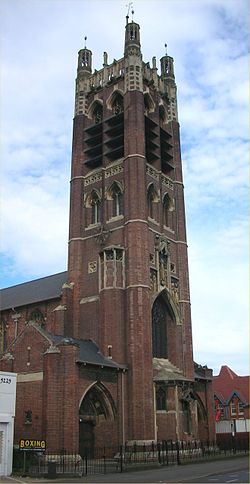
- St Agatha's Church, Sparkbrook
-
St Agatha’s Church, Sparkbrook 
Denomination Church of England Churchmanship Anglo Catholic Administration Deanery Yardley and Bordesley Archdeaconry Aston Diocese Birmingham Province Canterbury Clergy Vicar(s) The Rev’d Canon John Herve St Agatha's Church General information Type Church Location Sparkbrook, Birmingham, England Construction started October 1899 Completed 1901 Height 36.6 metres (120 ft) Design and construction Architect W. H. Bidlake Awards and prizes Grade I listed The Church of St Agatha (grid reference SP086847) is a parish church in the Church of England in Sparkbrook in Birmingham, England.
Contents
Background
It was designed by W. H. Bidlake. It is now a Grade I listed building.
Made of brick and decorated with stone, building started in October 1899. It was funded by the sale of the site of Christ Church, New Street which was demolished the same year to make way for shops and offices - Christchurch Buildings. That site later became Victoria Square after Christchurch Buildings were demolished in 1970. St Agatha was consecrated in 1901 by the Bishop of Worcester (Charles Gore) as Birmingham was in the diocese of Worcester until 1905 at which time Gore was made the first Bishop of Birmingham. A parish was assigned to the church in 1902 from Christ Church in Sparkbrook, and St. Paul's in Balsall Heath. The font and only bell came from Christ Church, along with its foundation stone dated 1805. In 1959, the church hall received a license for public worship.
The building has had an eventful history; the sanctuary end was completely destroyed by a German bomb in 1940 and the entire roof was lost in a fire in 1957. From 1940 to 1960 parts of the building were bricked off and the sense of lightness that the interior now has was temporarily lost.
The church was slightly damaged by the Birmingham Tornado on 28 July 2005. However the adjoining Ladypool Primary School was extensively damaged and lost its distinctive Martin & Chamberlain tower.
Major restoration work took place from 2002–2005, mostly funded by the National Heritage Lottery Board. This included the stabilisation of the tower. The restoration work was designed by Apec Architects.[1] The restored church was officially reopened in January 2005 by HRH Prince Edward and the Countess of Wessex.
Vicars and Priests-in-Charge
- Fr. Charles Wilcox 1889
- Fr. Gerald Vacqueray 1903
- Fr. Thomas Sanders 1910
- Fr. James Talbot 1912
- Fr. George Rosenthal 1918
- Fr. Alban Tilt 1939
- Fr. Eric Hill 1948
- Fr. Bernard Hopper 1955
- Fr. Neville Cox 1968
- Fr. Frederick Bernardi 1971
- Fr. Leonard Boyd 1978
- Canon Fr. John Hervé 1990
St Agatha's as a Church
From its beginning St Agatha's was strongly part of the Anglo-Catholic movement. Although situated in the Diocese of Birmingham the church is under the oversight of the Bishop of Ebbsfleet, the Provincial episcopal visitor and is a part of Forward in Faith. Until the 1950s there was a ring of similar churches around inner-city Birmingham - the so-called 'Biretta Belt'. Many of those churches have closed but St Agatha's itself remains open despite being in an almost entirely Muslim ward of the city. The church's priest is shared with St Barnabas' Balsall Heath.
Music
The church is noted for its music - supplemented by a recently restored four-manual Nicholson organ - liturgy and diverse congregation, and is well-known beyond the parish and the city.
Special Services
Celebrants have included the Archbishop of York, the Most Reverend David Hope at the centenary Mass in May 2001.
Facilities
The church hall is used by the Birmingham City Boxing Club, providing one of the very few facilities for all ethnicities[citation needed] of youth in the area.
Sources
- All About Victoria Square, Joe Holyoak, The Victorian Society Birmingham Group, ISBN 0-901657-14-X
- St Agatha website
- Images of England - details from listed building text
- British History Online: Churches built since 1800 - St Agatha, Sparkbrook, A History of the County of Warwick: Volume 7, 1964.
Buildings and structures in Birmingham, England Highrise
(in height order)Notable lowrise - 1–7 Constitution Hill
- 17 & 19 Newhall Street
- Assay Office
- Aston Hall
- Barber Institute of Fine Arts
- Baskerville House
- Blakesley Hall
- Central Library
- St. Chad's Cathedral
- Council House
- Curzon Street station
- Great Western Arcade
- ICC
- Island House
- St Martin in the Bull Ring
- Methodist Central Hall
- Millennium Point
- NIA
- Old Crown
- Perry Bridge
- St. Philip's Cathedral
- Pebble Mill Studios
- Proof House
- Sarehole Mill
- Symphony Hall
- Town Hall
- Victoria Law Courts
Major railway stations Hospitals - Queen Elizabeth
- Old Q.E.
- Selly Oak
- Good Hope
- Children's
Major hotels - Hyatt Regency
- Radisson Blu
Major complexes Sports venues - Alexander Stadium
- Edgbaston Cricket Ground
- Edgbaston Priory Club
- St Andrew's
- Villa Park
- Tallest
- Board schools
- Listed
- Category
Categories:- Grade I listed buildings in the West Midlands
- Grade I listed churches
- Church of England churches in Birmingham, West Midlands
- Religious buildings completed in 1901
Wikimedia Foundation. 2010.
