Dniprodzerzhynsk Reservoir

Dniprodzerzhynsk Reservoir
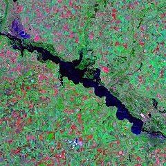
Landsat satellite photo
Location Dniprodzerzhynsk (to the south), Poltava, Kirovohrad and Dnipropetrovsk Oblasts, Ukraine
Coordinates 48°48′N 34°06′E / 48.8°N 34.1°E / 48.8; 34.1Coordinates: 48°48′N 34°06′E / 48.8°N 34.1°E / 48.8; 34.1
Lake type Hydroelectric reservoir
Primary inflows Dnieper River
Primary outflows Dnieper River
Basin countries Russia, Belarus, Ukraine
Surface area 567 km²
Water volume 2.45 km³

The Dniprodzerzhynsk Reservoir (Ukrainian: Дніпродзержинське водосховище, Dniprodzerzhyns'ke vodoskhovyshche) is a water reservoir located on the lower part of the Dnieper River in Ukraine. Named after the city of Dniprodzerzhynsk, it covers a total area of 567 square kilometres within the Dnipropetrovsk Oblast. It was formed in 1963-1965. The reservoir is mainly used for generating hydroelectric power, transportation, fish farming, and human consumption

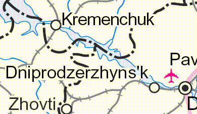
Map of the Dniprodzerzhynsk Reservoir.

The reservoir is 114 km in length, 5 km in width (8 km max.); has a depth of 15 meters, and a volume of 2.45 km³. During winter, the reservoir freezes over.

The ports of Kremenchuk and the Dnieper Mineral Enrichment Complex in Komsomolsk are located on the reservoir. The Dniprodzerzhynsk Hydroelectric Station, constructed during 1956–1965, is also located on the reservoir.
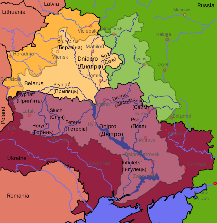

Wikimedia Foundation. 2010.

Игры ⚽ Поможем написать курсовую

Look at other dictionaries:

  • Kiev Reservoir — infobox lake lake name = Kiev Reservoir image lake = Landsat Kiev Water Reservoir1.jpg location = Kiev (to the north), Kiev Oblast, Ukraine basin countries= Russia, Belarus, Ukraine type = Hydroelectric reservoir inflow = Dnieper River outflow =… …   Wikipedia

  • Dnieper Reservoir — Location Zaporizhzhia (to the south), Dnipropetrovsk (to the north), Dnipropetrovsk and Zaporizhzhia Oblasts Coordinates …   Wikipedia

  • Threat of the Dnieper reservoirs — The water reservoirs of the Dnieper River in Ukraine pose a significant threat of a large scale human made disaster if their dams fail. Such a threat is typical for reservoir dams; however, the Dnieper reservoirs are especially dangerous because… …   Wikipedia

  • Verkhnodniprovsk — Infobox Settlement official name = Verkhnodniprovsk native name = Верхньодніпровськ nickname = imagesize = image caption = image shield = nickname = motto = mapsize = map caption = subdivision type = Country Oblast Raion subdivision name =Ukraine …   Wikipedia

  • Dniprodserschynsker Stausee — Dniprodserschynsker Stausee …   Deutsch Wikipedia

  • Dnieper Hydroelectric Station — The dam as seen from Khortytsia Island. Location Zaporizhia, Ukraine C …   Wikipedia

  • Disasters — ▪ 2009 Introduction Aviation       January 23, Poland. A Spanish built CASA transport plane carrying members of the Polish air force home from a conference on flight safety in Warsaw crashes near the town of Miroslawiec; all 20 aboard are killed …   Universalium

  • Drut River — Origin Belarus Mouth Dnieper Basin countries Belarus Length 295 km Avg. discharge 30 m³/s …   Wikipedia

  • Nikopol, Ukraine — For Nikopol in Bulgaria see Nikopol, Bulgaria. Nikopol (Нікополь) …   Wikipedia

  • Marhanets — (Ukrainian: Марганець; Russian: Марганец, literally manganese) is a mining city in Dnipropetrovsk Oblast of central Ukraine. It is located on the right bank of the Kakhovka Reservoir on the Dnieper River. City has about 50,000 inhabitants (2005) …   Wikipedia

Share the article and excerpts

Direct link
Do a right-click on the link above
and select “Copy Link”