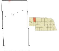
- Pine Ridge, Nebraska
-
Pine Ridge, Nebraska — CDP — Location of Pine Ridge, Nebraska Coordinates: 42°59′37″N 102°33′34″W / 42.99361°N 102.55944°WCoordinates: 42°59′37″N 102°33′34″W / 42.99361°N 102.55944°W Country United States State Nebraska County Sheridan Area – Total 1 sq mi (2.5 km2) – Land 0.9 sq mi (2.3 km2) – Water 0.1 sq mi (0.2 km2) Population (2000) – Total 14 – Density 14.5/sq mi (5.6/km2) Time zone Central (CST) (UTC-6) – Summer (DST) CDT (UTC-5) ZIP codes FIPS code GNIS feature ID Pine Ridge, commonly called Whiteclay, is a census-designated place (CDP) in Sheridan County, Nebraska, United States. The population was 14 at the 2000 census.
Contents
History
Whiteclay's history has always been tied to that of the Pine Ridge Indian Reservation, which is on the South Dakota side of the border. In 1882 after the boundaries of the reservation were already established, the United States government added a 50-square-mile (130 km2) strip of land in Nebraska known as the White Clay Extension (named after White Clay Creek) to the reservation by executive order. The area was created to serve as a buffer zone to help prevent the sale of alcohol to inhabitants of the reservation. The buffer zone was to continue until it was no longer considered necessary.
In 1905, President Theodore Roosevelt signed an executive order that removed 49 of the 50 square miles (130 km2) of the White Clay Extension from the reservation; the legality of this order has been disputed.[by whom?][citation needed]
Alcohol
The Oglala Sioux Tribe has continued the prohibition of the sale and possession of alcohol on the reservation. This has been a condition since the reservation was created. An exception was a brief period in the late 1970s when the tribe ran a pilot of on-reservation sales.[1] Residents have suffered a high rate of alcoholism combined with problems of poverty and unemployment.
Whiteclay, which has four liquor stores for its fourteen residents, has always been notable for the quantities of alcohol it sells to residents of the legally dry Pine Ridge reservation. The four stores in Whiteclay, which now sell only beer, sell an average of 4.5 million cans per year. This equates to over 12,300 cans per day, for gross sales of 3 million dollars annually.[citation needed]
The status of Whiteclay's beer stores has been a recurring political issue. In the late 1990s, a pair of unsolved murders of Lakota men in 1999 led to marches and rallies led by various activist groups, including the American Indian Movement (AIM) and Nebraskans for Peace, demanding that Nebraska revoke the area's liquor licenses and increase law enforcement in the area. The nearby Sioux tribal law enforcement in Pine Ridge, South Dakota had no legal authority in Whiteclay. The nearest Nebraska-based law enforcement is in Rushville, which is 22 miles (35 km) to the south.
In 2005, the state of Nebraska and President Cecilia Fire Thunder of the Pine Ridge reservation signed an historic agreement allowing Oglala tribal officers to enforce Nebraska laws in Whiteclay.[2] Congress earmarked $200,000 over two years to pay for the increased cost of patrols, but by May 2007, no money had been spent. Fire Thunder was impeached several months before the end of her term in 2006, and political conflict within the tribe appeared to have prevented its implementing the agreement. It stood to lose the earmarked money by October 2007.[3]
Geography
Pine Ridge is located at 42°59′37″N 102°33′34″W / 42.99361°N 102.55944°W (42.993658, -102.559497)[4].
According to the United States Census Bureau, the CDP has a total area of 1.0 square miles (2.5 km²), of which, 0.9 square miles (2.3 km²) of it is land and 0.1 square miles (0.2 km²) of it (8.33%) is water.
Demographics
As of the census[5] of 2000, there were 14 people, 7 households, and 3 families residing in the CDP. The population density was 15.8 people per square mile (6.1/km²). There were 9 housing units at an average density of 10.1/sq mi (3.9/km²). The racial makeup of the CDP was 35.71% White and 64.29% Native American.
There were 7 households out of which 14.3% had children under the age of 18 living with them, 42.9% were married couples living together, and 57.1% were non-families. 57.1% of all households were made up of individuals and 14.3% had someone living alone who was 65 years of age or older. The average household size was 2.00 and the average family size was 3.33.
In the CDP the population was spread out with 21.4% under the age of 18, 7.1% from 18 to 24, 28.6% from 25 to 44, 35.7% from 45 to 64, and 7.1% who were 65 years of age or older. The median age was 42 years. For every 100 females there were 75.0 males. For every 100 females age 18 and over, there were 83.3 males.
The median income for a household in the CDP was $61,250, and the median income for a family was $76,250. Males had a median income of $25,625 versus $53,750 for females. The per capita income for the CDP was $21,394. None of the population or the families were below the poverty line.
References
- ^ "$14,900 for Whiteclay".
- ^ "Bruning, Gov. Heineman Sign Deputization Agreement with Oglala Sioux". Press release, Nebraska governor's office, 2005-08-30. Retrieved 2011-02-27.
- ^ AP, "Two years after 'historic' agreement, no tribe patrols in Whiteclay", Rapid City Journal, 14 May 2007, accessed 13 June 2011
- ^ "US Gazetteer files: 2010, 2000, and 1990". United States Census Bureau. 2011-02-12. http://www.census.gov/geo/www/gazetteer/gazette.html. Retrieved 2011-04-23.
- ^ "American FactFinder". United States Census Bureau. http://factfinder.census.gov. Retrieved 2008-01-31.
Municipalities and communities of Sheridan County, Nebraska Cities Villages CDP Pine Ridge
Unincorporated
communitiesGhost town Antioch
Categories:- Census-designated places in Nebraska
- Populated places in Sheridan County, Nebraska
- Unincorporated communities in Nebraska
- Populated places in Nebraska with Native American majority populations
- Pine Ridge Indian Reservation
Wikimedia Foundation. 2010.

