- Hamilton East, New Zealand
-
Hamilton East 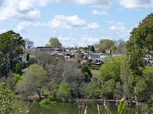
Hamilton East, viewed from Hamilton West.Basic information Local authority Hamilton, New Zealand Electoral ward Hamilton East Date established 1877 Population 10725 (2006 Census) Facilities Surrounds North Claudelands East Hillcrest Southeast Peacocke South Fitzroy West Hamilton West Northwest Hamilton Central Hamilton East is a suburb in central Hamilton in New Zealand. The suburb's primary commercial and retail precinct is located along Grey Street. Hamilton East is characterised by villas and bungalows built early in the 20th century.
Contents
History
Hamilton East is one of Hamilton's oldest suburbs. From the 1870s until the mid-20th century, Hamilton East was sometimes known as ‘Irishtown’. A significant number of the militiamen who settled there were of Irish descent, and many other Irish Catholics came to live near the Catholic Church and convent.
The town of Hamilton East merged with Hamilton West in 1877. Many of the streets were named after famous figures of the New Zealand Land Wars, including Governor George Grey and Maori chief Te Awaitaia, who went by the name William Naylor/Wiremu Neera when he converted to Christianity.[1] Evidence of planning for the centre of the village can be seen in the village green concept of Steele Park and the planting of English trees along Grey Street. Hamilton East is one of the few suburbs of Hamilton to have a street grid plan.
Many of the parks in Hamilton East, including Hamilton Gardens, are located on the original Hamilton Town Belt that runs along the eastern and southern border of Hamilton East.[2]
Features of Hamilton East
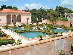 The Italian Renaissance Garden at Hamilton Gardens.
Hamilton Gardens
Main article: Hamilton GardensHamilton Gardens, a 58 hectare public park, is located along the banks of the Waikato River. Hamilton Gardens is the most popular visitor attraction in the region with about 1.3 million visitors each year, nearly half of them being tourists.[3] They were developed from the 1980s in stages, with paradise, productive, cultivar and landscape collections. The much-praised paradise collection includes a Chinese scholar’s garden, an English flower garden, a Japanese garden of contemplation, an American modernist garden, an Italian Renaissance garden and an Indian char bagh garden.[4]
Hayes Paddock
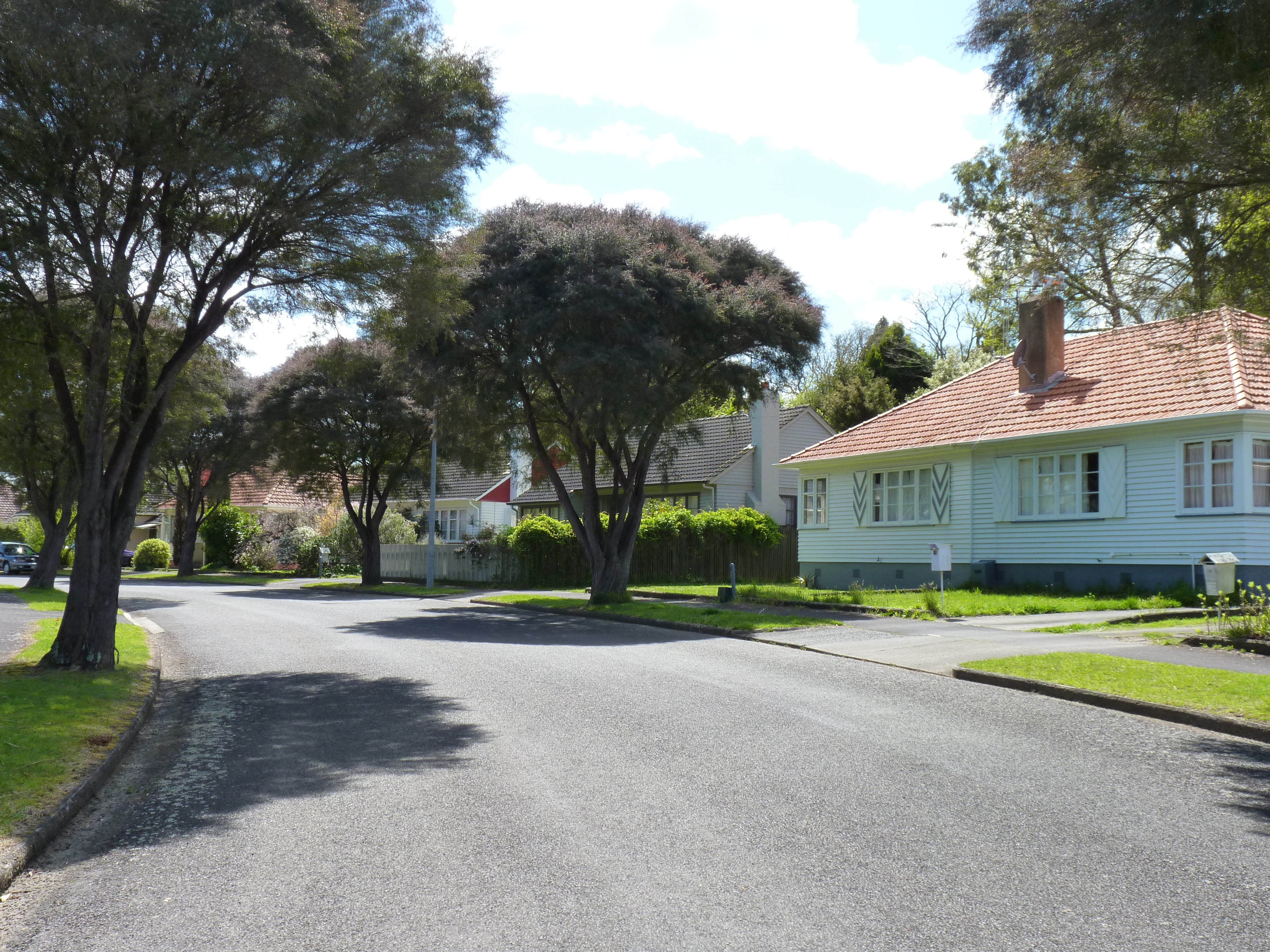
Hayes Paddock, an enclave in Hamilton East developed between 1939–1945, was planned and built according to the philosophies and ideals of the First Labour Government and the Garden City Movement. It includes curved street patterns, open plan garden layouts, low density development, and the provision of walkways and reserves. Hayes Paddock contains over 200 classic state houses built along seven streets named mostly after New Zealand governor generals.[5]
 Hayes Paddock, Hamilton East.
These governor generals were notable and influential men of their time. Macfarlane Street, the only street not named after a governor general, was named after James MacFarlane, a partner in the Auckland company of Henderson and MacFarlane.[6] The area that makes up Hayes Paddock was named after William Hayes who farmed the area, under lease, from 1903 to 1925.[7]
- Governor general from 1930-1935. Street: Bledisloe Terrace.
- Governor general from 1924-1930. Street: Fergusson Street.
- Sir George Vere Arundel Mockton-Arundel Galway
- Governor general from 1935-1941. Street: Galway Avenue.
- Governor general from 1920-1924. Street: Jellicoe Drive.
- Governor general from 1904-1910. Street: Plunket Terrace.
- Governor general from 1889-1892. Street: Onslow Street.
Thanks to Hamilton heritage enthusiasts and local council processes, Hayes Paddock has received protection in the city’s district plan.[8] The purpose of this protection was to safeguard the unique and special heritage of the Hayes Paddock area.[9]
An extensive chronology of key events from 1978, when Hayes paddock was first identified as having heritage value, to the May 2006 Council Report leading to the council decision, can be found in the Variation to Hamilton City District Plan version 2001.[10]
A final hearing of proposed changes was held in July 2008 and on 24 September 2008 a full Council confirmed the changes, subject to some amendments.[11][12]
Institute de Notre Dames des Missions
The Institute de Notre Dames des Missions is a Romanesque style convent and heritage site on Clyde St, Hamilton East. It was built of concrete and plaster, shielded from the road by a tall brick wall. In the 1930s, the convent was home to about 30 sisters who taught at three schools. Today, the convent is used as a hostel for 99 Sacred Heart Girls' College boarders. The exterior remains unaltered but there have been major changes inside.[13]
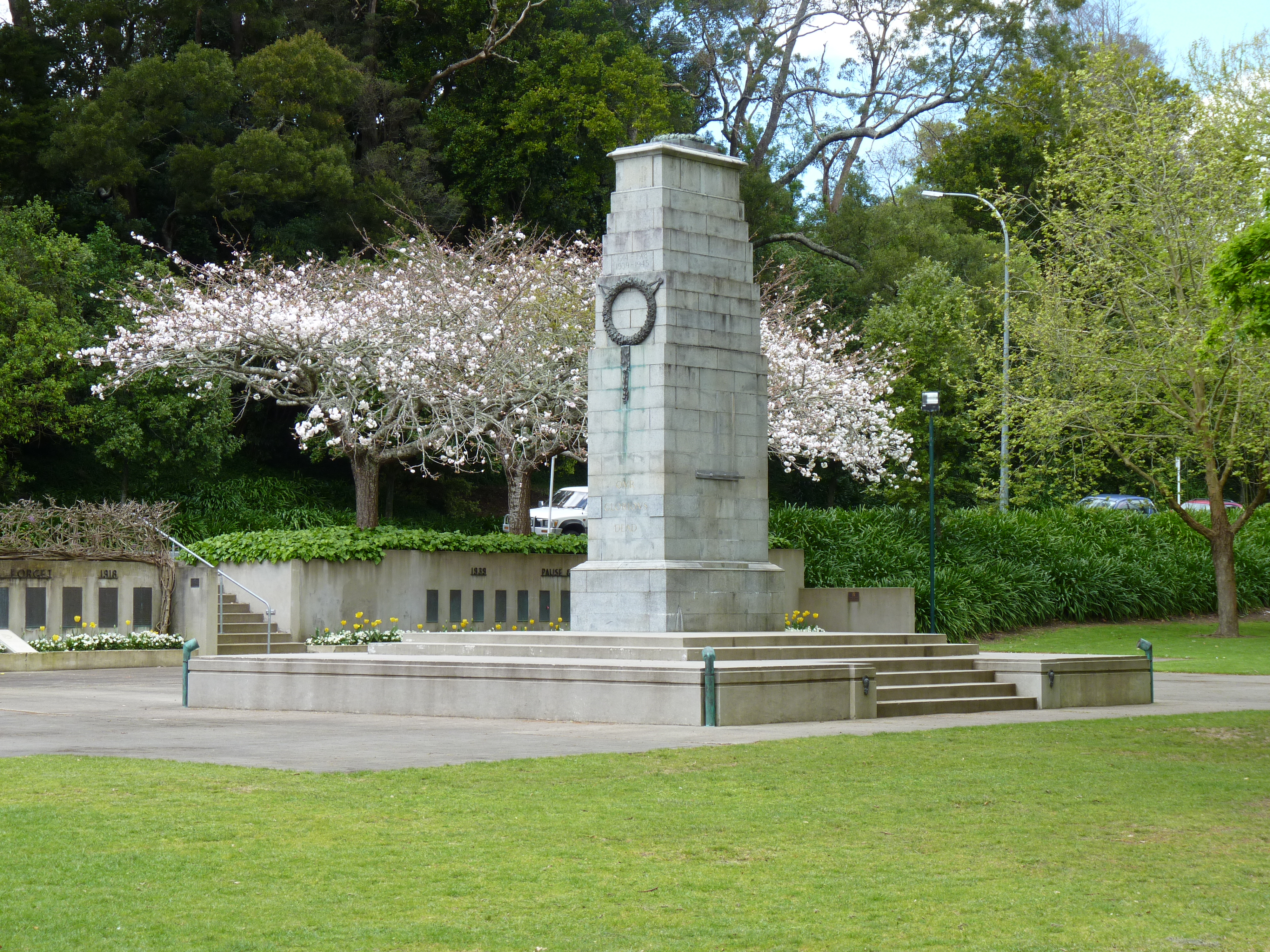
 Cenotaph at Memorial Park
Cathedral of the Blessed Virgin Mary
The modern Cathedral of the Blessed Virgin Mary was dedicated in 1980 and refurbished in 2008. It is the cathedral for the Hamilton Diocese.[14]
Memorial Park
Hamilton’s first militia settlers landed on this site in 1864. On the riverbank is the hulk of the paddle steamer Rangiriri, which brought the settlers upstream. The park and cenotaph were created in memory of First World War soldiers. The park was further developed with a Second World War memorial as well as a Spitfire air-force memorial.[4]
Steele Park
 Beale Cottage
At the centre of Hamilton East is Steele Park, named for militia officer William Steele. It was originally called Sydney Square, after the New South Wales city where members of the 4th Waikato militia enlisted. The oaks around its perimeter were planted in 1889, the silver jubilee of the arrival of militia settlers. Historically used for social gatherings for settlers, today it continues to be an important venue for sport, cultural and social events. The Loyal Hamilton Lodge of the Independent Order of Oddfellows was built in 1874 on the perimeter of Steele Park. It is now The Cook Cafe and Bar.[15]
Galloway Park
A former redoubt, Galloway Park is now an active sports park utilised for a variety of summer and winter sports. In summer, it is primarily used for cricket and in winter, it is primarily used for soccer.
Greenslade House
Greenslade House is a distinctive Edwardian house on Wellington Street. It was built between 1910-1912 for a prominent Hamilton businessman and New Zealand Liberal Party MP, Henry Greenslade. The architect, John W Warren, also helped design the Waikato Hospital. It remains a private residence, but it is open to the public several days a week as an art gallery.[16]
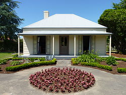
Beale Cottage
Main article: Beale CottageThe tiny cottage on the corner of Beale and Grey Streets is Hamilton's oldest remaining house, named after the 4th Mayor of Hamilton, Bernard Charles Beale. He designed and built the simple cottage in 1872 using locally-grown kauri and kahikatea. Soon after, he added several more rooms. One room in the house was used as a surgery.
Nga Uri o Hinetuparimaunga
Located at the entrance to Hamilton Gardens, Nga Uri o Hinetuparimaunga is a sculpture created by two internationally renowned artists, sculptor Chris Booth and Diggeress Te Kanawa. Their design proposal was chosen in a competition to which top New Zealand artists had been invited to submit designs. The woven Hinuera stone cloak sculpture honours natural creative processes.[17]
Demographics
According to the 2006 census, Hamilton East has a population of 10725. Approximately 25% of the population were born outside of New Zealand.[18][19][20] The Index of Socioeconomic Deprivation, ranked 1-10 from lowest to most deprived areas, lists the Clyde Street zone of Hamilton East at 9/10 (high deprivation), the Peachgrove zone at 8/10 (high deprivation) and the Naylor Street zone at 7/10 (moderate deprivation).[21]
Education
- Hamilton Boys' High School is a single sex secondary school (years 9-13). It has a decile rating of 8 and a roll of 2042.[22]
- Hamilton East Primary School is a coeducational primary school (years 1-8). The school was opened in 1872 and is the oldest school in Hamilton on its original site. It has a decile rating of 4 and a roll of 291.[23]
- Marian Catholic School is an integrated coeducational full primary school (years 1-8). The school was formed in 1989 by the amalgamation of the single-sex St Mary’s Cathedral School and Marist School, which had been neighbours on the same site.[24] It has a decile rating of 7 and a roll of 598.[25]
- Sacred Heart Girls' College is a single sex integrated Catholic boarding and day school. The school was established in 1884 and has a role of 858.[26]
- Patricia Avenue School is a special needs school. It has a decile rating of 5 and a roll of 133.[27]
See also
References
- ^ Street Name Index - Hamilton Public Library, Hamilton.
- ^ Westwood, L.G. (1962). Hamilton City - Its Establishment and Development.
- ^ "Hamilton Gardens". Hamilton City Council. http://www.hamiltongardens.co.nz/index.asp?pageID=2145827622. Retrieved 3 September 2010.
- ^ a b "Hamilton, east of the river". Te Ara Encyclopedia of New Zealand. http://www.teara.govt.nz/en/waikato-places/8. Retrieved 3 October 2010.
- ^ "Hamilton east of the river". Te Ara Encyclopedia of New Zealand. http://www.teara.govt.nz/en/waikato-places/8. Retrieved 3 September 2010.
- ^ McEwan, Ann (2008). “The Houses of Hayes Paddock: Hamilton”, p.119. Ramp Press, Hamilton, New Zealand. ISBN 978-0-9582902-4-1
- ^ McEwan, Ann (2008). “The Houses of Hayes Paddock: Hamilton”, p.15. Ramp Press, Hamilton, New Zealand. ISBN 978-0-9582902-4-1
- ^ "Hamilton, east of the river". Te Ara Encyclopedia of New Zealand. http://www.teara.govt.nz/en/waikato-places/8. Retrieved 31 March 2011.
- ^ "Variation 11". Hamilton City Council, New Zealand. http://hamilton.co.nz/page/pageid/2145832632/No.11. Retrieved 31 March 2011.
- ^ "Hamilton City Proposed District Plan (References Version 2001)". Hamilton City Council, New Zealand. http://hamilton.co.nz/file/fileid/2096. Retrieved 31 March 2011.
- ^ "Variation No. 11". Hamilton City Council, New Zealand. http://hamilton.co.nz/page/pageid/2145832632/No.11. Retrieved 31 March 2011.
- ^ "Decisions on Submissions to Variation No.11: Hayes Paddock Special Character Area". Hamilton City Council, New Zealand. http://hamilton.co.nz/file/fileid/1040. Retrieved 31 March 2011.
- ^ "Institute de Notre Dames des Missions". Hamilton City Council. http://hamilton.co.nz/page/pageid/2145832751. Retrieved 3 October 2010.
- ^ "Hamilton east of the river". Te Ara Encyclopedia of New Zealand. http://www.teara.govt.nz/en/waikato-places/8. Retrieved 3 October 2010.
- ^ "Buffalo Hall". Hamilton City Council. http://hamilton.co.nz/page/pageid/2145832749. Retrieved 3 September 2010.
- ^ "Greenslade Gallery". http://greensladegallery.co.nz/. Retrieved 17 December 2010.
- ^ "Sculpture at Hamilton Gardens". Hamilton Gardens. http://www.hamiltongardens.co.nz/index.asp?PageID=2145831362. Retrieved 3 October 2010.
- ^ "Quickstats Hamilton East". Statistics New Zealand. http://www.stats.govt.nz/Census/2006CensusHomePage/QuickStats/AboutAPlace/SnapShot.aspx?type=au&ParentID=1000003&ss=y&tab=Culturaldiversity&id=3530200. Retrieved 3 October 2010.
- ^ "Quickstats Naylor". Statistics New Zealand. http://www.stats.govt.nz/Census/2006CensusHomePage/QuickStats/AboutAPlace/SnapShot.aspx?type=au&ParentID=1000003&ss=y&tab=Culturaldiversity&id=3530300. Retrieved 3 October 2010.
- ^ "Quickstats Peachgrove". Statistics New Zealand. http://www.stats.govt.nz/Census/2006CensusHomePage/QuickStats/AboutAPlace/SnapShot.aspx?id=3530100&type=au&ParentID=1000003&expand=2000016&scrollLeft=0&scrollTop=596&ss=y. Retrieved 30 November 2010.
- ^ "Index of Socioeconomic Deprivation for Areas within the Hamilton East Electorate". Parliament New Zealand. http://www.parliament.nz/en-NZ/MPP/Electorates/EPData/e/c/5/DBHOH_Lib_EP_HamiltonEast_Data_5-Hamilton-East-Households.htm. Retrieved 3 October 2010.
- ^ "Te Kete Ipurangi school data". http://www.tki.org.nz/Schools?&location=Hamilton%20City&schoolSearch=true. Retrieved 2010-11-30.
- ^ "Te Kete Ipurangi school data". http://www.tki.org.nz/e/schools/display_school_info.php?school_id=2094. Retrieved 2010-10-03.
- ^ "Marian School website". http://www.marian.school.nz/page/4. Retrieved 2008-03-22.
- ^ "Te Kete Ipurangi school data". http://www.tki.org.nz/e/schools/display_school_info.php?school_id=2094. Retrieved 2008-03-22.
- ^ "Sacred Heart College website". http://www.shgcham.school.nz/. Retrieved 2009-07-29.
- ^ "Te Kete Ipurangi school data". http://www.tki.org.nz/Schools?school_name=&location=Hamilton&type=&gender=&authority=&schoolSearch=true&Search=Search. Retrieved 2010-10-03.
Coordinates: 37°47′49″S 175°17′53″E / 37.797°S 175.298°E
Hamilton, New Zealand Suburbs Ashmore · Beerescourt · Callum Brae · Chartwell · Chedworth Park · Claudelands · Crawshaw · Deanwell · Dinsdale · Enderley · Fairfield · Fairview Downs · Fitzroy · Flagstaff · Forest Lake · Frankton · Glenview · Grandview Heights · Hamilton Central · Hamilton North · Hamilton East · Hamilton West · Harrowfield · Hillcrest · Huntington · Livingstone · Magellan Rise · Maeroa · Melville · Peacocke · Pukete · Queenwood · Ruakura · Riverlea · Rotokauri · Rototuna · Silverdale · St Andrews · St James Park · St Petersburg · Somerset Heights · Stonebridge · Te Rapa · Temple View · Thornton · Western Heights · Whitiora ·Urban Area Schools Sports teams Facilities and Attractions Hamilton Gardens · Hamilton City Libraries · Hamilton Zoo · Seddon Park · St Peter's Cathedral · Waikato Museum · Waikato Stadium · Waterworld pool complexOther Categories:- Suburbs of Hamilton, New Zealand
- Waikato Region geography stubs


Wikimedia Foundation. 2010.