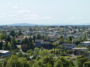
- Dinsdale, New Zealand
-
Dinsdale 
Dinsdale, HamiltonBasic information Local authority Hamilton, New Zealand Electoral ward Hamilton West Date established 1962 Population 7773 (2006 Census) Facilities Surrounds North Livingstone Northeast Frankton Southeast Melville Southwest Stonebridge Northwest Western Heights Dinsdale is the westernmost suburb of Hamilton in New Zealand. Originally called Frankton West, it was renamed on July 1961 after Thomas Dinsdale. Dinsdale grew rapidly in the 1960s.[1] It is located around a low ridge with some views westward to open farm land.It has some large sports grounds and shoping complex with a supermarket ,library,garage and some 25 shops.Its nearest secondary school is Hamilton's Fraser High School a large co-educational, mid decile school just to the north of Dinsdale.
See also
References
- ^ Dinsdale — Where Town Meets Country.
Coordinates: 37°47′45.42″S 175°14′33.28″E / 37.79595°S 175.2425778°E
Hamilton, New Zealand Suburbs Ashmore · Beerescourt · Callum Brae · Chartwell · Chedworth Park · Claudelands · Crawshaw · Deanwell · Dinsdale · Enderley · Fairfield · Fairview Downs · Fitzroy · Flagstaff · Forest Lake · Frankton · Glenview · Grandview Heights · Hamilton Central · Hamilton North · Hamilton East · Hamilton West · Harrowfield · Hillcrest · Huntington · Livingstone · Magellan Rise · Maeroa · Melville · Peacocke · Pukete · Queenwood · Ruakura · Riverlea · Rotokauri · Rototuna · Silverdale · St Andrews · St James Park · St Petersburg · Somerset Heights · Stonebridge · Te Rapa · Temple View · Thornton · Western Heights · Whitiora ·Urban Area Schools Sports teams Facilities and Attractions Hamilton Gardens · Hamilton City Libraries · Hamilton Zoo · Seddon Park · St Peter's Cathedral · Waikato Museum · Waikato Stadium · Waterworld pool complexOther Categories:- 1962 establishments
- Suburbs of Hamilton, New Zealand
- Waikato Region geography stubs
Wikimedia Foundation. 2010.
