- Cowdenbeath
-
Coordinates: 56°07′N 3°21′W / 56.11°N 3.35°W
Cowdenbeath Scottish Gaelic: Cùl Dùn Beithe Scots: Coudenbaith[1] 
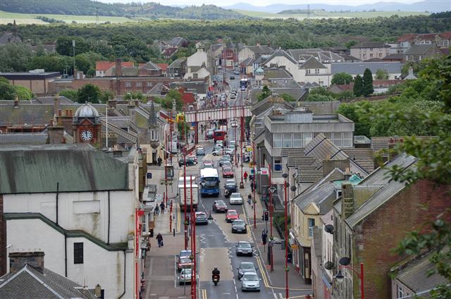
View down Cowdenbeath High Street from the North End War Memorial.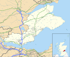
 Cowdenbeath
Cowdenbeath shown within FifePopulation 11,640 [2] OS grid reference NT160916 Council area Fife Lieutenancy area Fife Country Scotland Sovereign state United Kingdom Post town COWDENBEATH Postcode district KY4 8, KY4 9 Dialling code 01383 Police Fife Fire Fife Ambulance Scottish EU Parliament Scotland UK Parliament Kirkcaldy and Cowdenbeath Scottish Parliament Cowdenbeath Mid Scotland and Fife List of places: UK • Scotland • Cowdenbeath (
 listen (help·info); Scots: Coudenbaith, Scottish Gaelic: Cùl Dùn Beithe)[citation needed] is a town and burgh in west Fife, Scotland. It is 5 miles north-east of Dunfermline and 18 miles north of the capital, Edinburgh. The town grew up around the extensive coalfields of the area and became a Police Burgh in 1890. According to a 2008 estimate, the town has a population of 11,640.
Contents
History
The earliest indication of human activity in the immediate vicinity of the current site of Cowdenbeath was provided by the discovery of late bronze-age vessels containing incinerated human remains, in 1928. An article by A.D. Lacaille F.S.A Scot [3] details the find of a late bronze-age cemetery near Tollie Hill. One of the urns found contained fragments of processed Arran pitchstone, indicating some economic activity & commerce.
There is no evidence of a permanent settlement establishing itself around the current site of Cowdenbeath until the designation of the original Beath Kirk as a parish church in 1429/30 to act as a focal point to serve the surrounding area. The earliest written record of Beath (Beth), was found in a charter of Inchcolm Abbey, dated 6 March 1178. This charter makes reference to the Chapel of Beth. Although it is generally accepted that the word ‘Beath’ in Gaelic means ’birch wood’, P.W. Brown suggests that the word means ‘abode’ or ‘a settlement.’ In 1643, the Parish of Beath was separated from Dalgety Bay and Aberdour. This significant date followed the building of a new church in 1640 at Beath, to replace the ruins of a sanctuary, which had fallen into sad disrepair.[4]
By 1790 the records show that the parish of Beath had about 100 families whose livelihood came mainly from the soil. The fact that Beath Church served a very large area led to the creation of many "kirke roads", roads that form right-of-way even today.[5] This church was replaced by the present church, built in 1832 and enlarged in 1886.
Cowdenbeath first came into prominence around 1820 as a stop on the north-bound coaching route to Perth. Indeed, Queen Victoria's entourage stopped at the Cowdenbeath Coaching Inn to change horses, on her first trip to Scotland in 1842, en route for Balmoral. The coaching inn, the Old Inn, was established at the junction of roads from North Queensferry, Perth, Dunfermline and Burntisland. When the new turnpike road from Queensferry to Perth was constructed, the Inn gained more importance.[6]
Prior to 1850, Cowdenbeath was just a collection of farms within the Parish of Beath. The area was divided into four districts named after local farms: Kirkford, Foulford, White Threshes and Cowdenbeath farm, located close to the present-day site of Central Park.[7] Local inhabitants of these focal points of growth, which were merging into a single town, met to decide on a name for the emerging town. The eventual decision was narrowed down to either White Threshes or Cowdenbeath and Cowdenbeath was the chosen name. The arrival of the Oakley Iron Company around 1850 was to have a long-lasting impact upon Cowdenbeath and make the name synonymous with coal-mining for almost 100 years. Shafts were sunk in the vicinity of the old Foulford Washer. It was in the mining for ore that the discoveries of the coal seams were made, and pits were sunk at every corner of the town. Prior to this, coal had been mined at Fordell for over a century, but the discovery of the coal seams at the depth they were found came as a pleasant surprise, considering the dip in the coal strata at Fordell, as it was previously thought that the seams at Cowdenbeath would be at such a depth as to be almost unworkable.[8]
By 1850, the flourishing coal pits of Kelty, Lochgelly, Donibristle, Fordell and Hill of Beath surrounded the hamlet of Cowdenbeath. Within the greater area, which later became the Burgh of Cowdenbeath, there was little mining activity. Gibson, of Hill of Beath, and the Symes, of Cartmore, had opened small pits in the vicinity of Jubilee Park at the southern border of the Burgh, and other small pits appear to have been worked in the vicinity of Union Street. However, the situation was about to change when (contrary to earlier speculation) the Oakley Iron Company proved the area was rich in iron and coal. The opening of the Dunfermline-Thornton railway, via Cowdenbeath, in 1848, enhanced the prospects for mining and pits were literally sunk in every corner of the area, primarily for ironstone, but when this became uneconomic around the late 1870s, for coal alone.
The Forth Iron Company took over the Oakley Iron Company around 1860 then amalgamated with the Cowdenbeath Coal Company in 1872. When the Fife Coal Company subsequently took them over in 1896, the Cowdenbeath Coal Company's pits were listed as: Lumphinnans Nos. 1, 2, 7, 11; Cowdenbeath Nos. 3, 7, 9; Foulford No. 1 and Mossbeath. This effectively made the Fife Coal Company one of the largest coal mining concerns in Scotland. Such was the upsurge in mining activity that the population of Cowdenbeath doubled (4,000 - 8,000) in the ten years between 1890 and 1900 and gave rise to the nickname "Chicago of Fife". This was a significant increase on the 1820 figure of 120.[9]
Such was the extent of the importance of Cowdenbeath to coal mining at the turn of the century (circa 1900) that several institutions essential to mining became established there. The headquarters offices of the Fife Miners’ Association were opened in Victoria Street on 8 October 1910, the first Mine rescue station opened at Cowdenbeath on 4 November 1910 on Stenhouse Street, opposite Beath High School.[10] The Central Works, Cowdenbeath, (commonly referred to as "The Workshops") were built in 1924 by the Fife Coal Company Limited in order to centralise its supervisory staff and to cope with the greater amount of manufacturing and maintenance work caused by the intensive mechanisation programme which was being introduced in its mines.[9]
Another significant mining-related building, which reflected Cowdenbeath's growing status at the forefront of mining technology, was the establishment of the Fife Mining School in 1895. The school had humble origins, operating out of two rooms in Broad Street School, until it was transferred to the basement of Beath High School on Stenhouse Street. It was not until 1936 that Fife Mining School acquired its own custom-built building on the site of the old Woodside House on Broad Street. The new Fife Mining School was erected at a cost of £22,500, and was opened on 22 March by Mr Ernest Brown, MP, then Parliamentary Secretary to the Mines Department.[11] The school trained apprentices in all aspects of the mining trade, however, it did have a temporary change of use during both World Wars, when it was used to train women working in the munitions industry. The mining school closed in 1976, reflecting the diminishing role of coal-mining in the community.[9]
Geography
Cowdenbeath lies in south-western Fife, near to the larger town of Dunfermline. Its precise coordinates are 56.11°N 3.35°W. The town lies in a low, undulating, arable landscape to the south east of the Ochil Hills. Whilst for the main part Cowdenbeath is fairly level, there are significant portions of the town which have succumbed to subsidence as a result of the network of mineshafts and tunnels underlying the town. Notably, there are photographs of Cowdenbeath High Street published in Stenlake Publications [12] which depict Cowdenbeath High Street circa 1900, and which shows a flat High Street in which it is possible to view its entire length from north to south under the overarching railway bridge. This is impossible today, as the subsidence on the High Street has been so great that the railway bridge now obscures the view from one end to the other.
The south and eastern boundaries of Cowdenbeath are circumscribed by the A92 main road to Kirkcaldy, and beyond that the peat-bog and petrochemichal plant of Mossmorran.
The western perimeter of Cowdenbeath merges into the neighbouring village of Hill of Beath, and is bound by the natural landscape of the gentle slopes of the hill itself, and by Loch Fitty. The proximity of the M90 motorway to the south of Cowdenbeath, and to the east at a lesser extent also serves to define its lower boundary.
The northern boundary of Cowdenbeath is characterised by a rural landscape, which merges into the Lochore Meadows Country Park ("The Meadies"). This formerly industrial/mining landscape which was host to a number of pit-heads (including the Mary Pit - whose winding gear structure dominates the park as a monument to its mining legacy) is now a very pituresque area which provides leisure and recreational outdoor amenities.
Sport and Leisure
Cowdenbeath Leisure Centre is located in Pit Road, next to Central Park in the centre of the town and has a swimming pool, gym, indoor sports facilities and three all-weather pitches for tennis or football. A small skatepark is situated outside the leisure centre. There are a number of playing fields situated around the town.[13]
The expansive 'Public Park' is situated towards the north of the town. It was established in 1910, and formally opened in 1911. The venture was largely funded by the Gothenburg Public House Society, which donated over £7,000 to the initiative. In its prime the park boasted an ornate bandstand, a paddling-pool, putting-course and swing-park, and was a focal point for various leisure pursuits, and the venue for the annual "Store" (Co-operative Society) treat. Although most of these amenities have long since gone, the park is still tended by the local authority and provides a public open space for all to use.
Cowdenbeath also has a golf club which was originally built as a 9 hole course on the old Dora Coal mine site. Work began in 1988 and the course was completed and ready for play in 1991. The length of the course was 3315 Yards. The course was extended to 18 holes and opened by Sir Michael Bonallack in 1996. The length of the course is now 6207 yards with a standard scratch score of 71. A new clubhouse was built and officially opened on 6 December 1998 by ex-provost James Cameron who had opened the first clubhouse. There had been a golf club at the northern end of the town before WW2, resulting in one of the now-demolished houses being name "Golf View".[14]
Central Park is a rather dilapidated stadium in the centre of Cowdenbeath. It is home to Cowdenbeath F.C. and has a maximum capacity of 5,270 (1,620 covered seating).
The stadium has a tarmac track encircling the football pitch, one of Britain's fastest, used for stock-car racing. It has recently been announced however that the stadium has been sold for redevelopment (possibly a new retail park) with a new one being built nearby for the football club, complete with an all weather pitch. Central Park is the site of Britain's most northerly speedway track. The team based in Cowdenbeath were known as the Fife Lions and featured riders from Edinburgh Monarchs and Glasgow Tigers in a series of challenge matches against league teams and scratch sides. The speedway track, which staged 8 meetings including a world championship qualifying round, was unusual in that it featured a brick wall safety fence.
Other amenities
The Medical Practice and Police Station are situated on Stenhouse Street. There is a library situated at the north end of the High Street. There is a post office situated near the middle of the High Street nearly opposite the Town House. The red sandstone Town House building is situated in the centre of the High Street. This sandstone is the same stone that was used to construct the original Beath High School on Stenhouse street. The remnants of the stone can be seen to this day forming a low wall around the sheltered housing which now occupies the site of the old high school.
Education
There are three primary schools in the town. Cowdenbeath Primary School serves the southern end of the town. Foulford Primary School serves the northern end of the town. St Bride's Primary School, the only Roman Catholic primary, serves both the town as well as Crossgates, Hill of Beath and Lumphinnans. Some pupils in the north east and south west of the town attend Lumphinnans and Hill of Beath primary schools respectively.
Cowdenbeath is also served by one secondary school. Beath High School was founded in 1910 as a grammar school mainly for the children of local mine executives. It was an imposing building built of red sandstone and stood on Stenhouse Street. Unfortunately, the mine-works emanating from the No. 7 pit, whose, original pit-head was in close proximity to the school, caused significant subsidence in latter years. A modern school was opened in 1964, built in Kirkford next to Kirk of Beath Church and cemetery. At this point the school was split, with the old building becoming the lower school, and subsequently commonly referred to as "Old Beath", whilst the modern school was referred to as "New Beath". The old building was demolished in the 1990s and in 2003 the "new" school, itself, was closed due to subsidence and a new Public Private Partnership school was built. It is maintained by Sodexo.
On 25 March 1983, Mrs Jane Cosans of Cowdenbeath changed discipline in Scottish schools. She was awarded £11,846 by the European Court of Human Rights, plus costs, as recompense for her son's suspension from Beath High School for refusing to be belted. This significantly contributed to the banning of the use of the belt in Scottish schools.[15][16][17]
Notable people
Alumni of Beath High School include:
- Nobel Prize winner, Sir James Black, whose work is behind the drug Ranitidine. In an excerpt from his autobiography, Sir James is quoted as saying: "The imprinting mathematical influence was Dr Waterson at Beath High School, a brilliant and rumbustious teacher, who more or less man-handled me into sitting the competitive entrance examination for St Andrews University." [18]
- Jennie Lee, Baroness Lee of Asheridge, attended Beath High School. She graduated from Edinburgh University and worked as a teacher in Cowdenbeath before being adopted the ILP candidate for the North Lanarkshire constituency, which she won at a 1929 by-election, becoming the youngest member of the House of Commons. A member of Harold Wilson's government of 1964, she was influential in the creation of the Open University. Her father was manager of the Crown Hotel at the north end of the High Strret, which was destroyed by fire on 13 May 2009. Her husband was Aneurin Bevan MP.[19]
- Another noteworthy student of Beath was James Curran Baxter, or "Slim Jim" Baxter, one of Scotland's most prolific football players. A statue commemorating Jim Baxter can be found in adjacent Hill of Beath, his home village, outside the working men's club.
- Ian Rankin, the author of the Inspector Rebus novels also attended Beath High School.
- Dennis Canavan, the Scottish politician and Member of Parliament for Falkirk West was born in Cowdenbeath in 1942 and attended St Brides Primary School.
- Harry Ewing (Baron Ewing of Kirkford) was born in Cowdenbeath in 1931. Son to miner, William Ewing, Harry served as a Member of Parliament for 21 years before being made a life peer.
- Donald Findlay QC, born in Cowdenbeath on March 17, 1951 is a well known senior advocate and Queen's Counsel in Scotland. He has also held positions as a vice chairman of Rangers Football Club and twice Rector of the University of St Andrews. He is now the chairman of Cowdenbeath FC.
- Scott Brown attended Beath High School. He was born in Dunfermline on 25 June 1985 and has played for Hibernian, Celtic and Scotland.
- Tom Kellichan, drummer of punk rock band The Skids from 1977 to 1980, lived there.[20]
- Illustrator William McLaren (1923 - 1987) attended Beath High School.
Transport
The A92 Fife Regional Road is a motorway-standard dual carriageway road running from the M90 motorway (which runs from Edinburgh to Perth) in Dunfermline to Kirkcaldy (and further to Glenrothes, Dundee and Aberdeen). The A92 bypasses the east of the town with a junction at Bridge Street.
Cowdenbeath railway station is situated just off the High Street, via a steep ramp to/from each platform. It is on the Fife Circle Line with a half-hourly service to Edinburgh (Monday to Saturday daytimes).[21]
Bus Services
Service Destination Via Frequency 16 Kirkcaldy Auchtertool Infrequent 17 Kelty Leuchatsbeath Drive Every hour (daytime only) 17 Crossgates Church Street, Mossgreen Every hour (daytime only) 17A Kelty Stenhouse Street, Foulford Road, Leuchatsbeath Drive Every hour (evenings and sundays only) 17A Moss-Side Estate Broad Street, Moss-Side Road Every hour (evenings and sundays only) 17B Kelty Stenhouse Street, Foulford Road, Leuchatsbeath Drive Every hour (daytime only) 17B Barclay Street Broad Street, Selkirk Avenue, Rae Street, Moss-Side Estate Every hour (daytime only) 18 Kelty Leuchatsbeath Drive Every hour 18 Kirkcaldy A92 dual carriageway Every hour 19 Rosyth Hill of Beath, Crossgates, Halbeath, Dunfermline Every 10 minutes 19 Ballingry Lumphinnans, Lochgelly, Crosshill Every 10 minutes 30 Dunfermline Hill of Beath, Crossgates, Halbeath, QM Hospital Every hour 30 Glenrothes Lumphinnans, Lochgelly, Crosshill, Ballingry, Kinglassie Every hour 33 Dunfermline Hill of Beath, Crossgates, Halbeath, QM Hospital Every hour 33 Kirkcaldy Lumphinnans, Lochgelly, Cardenden Every hour 56 Perth Kelty, Kinross, Glenfarg, Bridge of Earn Infrequent References
- ^ Scots Language Centre: Scottish Place Names in Scots
- ^ "Mid-2008 Population Estimates – Localities in order of size". General Register for Scotland. 2008. http://www.gro-scotland.gov.uk/files2/stats/population-estimates/08mye-localities-table2.xls. Retrieved 2010-09-19.
- ^ Archaeology article
- ^ http://www.grayhome.force9.co.uk/Discovering%20Our%20Roots.pdf A Brief History of Presbyterian Churches by Leslie Barr
- ^ Black Diamonds and the Blue Brazil by Ronald Ferguson
- ^ http://archiver.rootsweb.ancestry.com/th/read/SCT-FIFE/1999-09/0936951570 History of Cowdenbeath
- ^ http://google.com/search?q=cache:3A7pS8tmDxAJ:newsarch.rootsweb.com/th/read/SCT-FIFE/1999-09/0938230111+%22white+threshes%22&hl=en&ct=clnk&cd=2&gl=uk History of Cowdenbeath
- ^ History of Cowdenbeath by Robert Holman
- ^ a b c Fife Pits and Memorial Book by Michael Martin
- ^ Dunfermline Press Archives
- ^ http://www.dunfermlinepress.com/bygone_dunfermline/years/1930_1945.php?bygone_id=3 Bygone Dunfermline (Dunfermline Press 1930-1945
- ^ http://www.stenlake.co.uk/tvcs.htm Stenlake Publishing
- ^ Cowdenbeath Leisure Centre
- ^ Cowdenbeath Golf Club
- ^ Hansard article
- ^ http://www.dunfermlinepress.com/bygone_dunfermline/years/1976_1986.php?bygone_id=6 Dunfermline Press
- ^ http://books.google.co.uk/books?id=yzfTNd8mousC&pg=PA55&lpg=PA55&dq=%22jane+Cosans%22+cowdenbeath&source=web&ots=NxnqqT5laz&sig=r0MEY7pKh2MXlYAlxxuCiUvkyNk&hl=en&sa=X&oi=book_result&resnum=3&ct=result Strasbourg Ruling
- ^ http://nobelprize.org/nobel_prizes/medicine/laureates/1988/black-autobio.html Nobel Prize Winner
- ^ http://www.electricscotland.com/history/women/wih29.htm Women in History of Scots Descent
- ^ [1]
- ^ http://www.nationalrail.co.uk/stations/cow/details.html National Rail Enquiries
External links
Categories:- Burghs
- Towns in Fife

Wikimedia Foundation. 2010.