- Mullan Pass
-
Mullan Pass
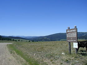
Historical marker placed at Mullan Pass.Elevation 5,902 ft (1,799 m) Traversed by Austin-Mullan Pass Road and Montana Rail Link (via Mullan Pass Tunnel). Location Location Lewis and Clark / Powell counties, Montana,  United States
Range Rocky Mountains Coordinates 46°38.18′N 112°18.5′W / 46.63633°N 112.3083°W The Mullan Pass is a mountain pass in the Rocky Mountains of Montana in the United States. It sits on the continental divide on the border between Powell County, Montana and Lewis and Clark County, Montana, 13.25 miles (21.32 km) west of Helena, Montana in Helena National Forest at a height of 5,902 feet (1,799 m).
The Northern Pacific Railway used the pass for its line from Logan, Montana to Garrison, Montana via Helena built in 1883. The line was the NP’s primary freight route, and was also used by their secondary passenger train, the Mainstreeter. The NP also built a line over Homestake Pass, which was used by their primary passenger train, the North Coast Limited. The rail line over Mullan Pass is currently operated by Montana RailLink. The line crosses under the pass and continental divide at an elevation of 5,566 feet (1,697 m) via the 3,426-foot (1,044 m) long Mullan Tunnel.
The pass was named after Lieutenant John Mullan, the army engineer who first crossed the pass on March 22, 1854 and later supervised construction of Mullan Road, the first road over the pass, in 1860.
Contents
Collapse
In July 2009 the railroad tunnel had part of the roof collapse during renovation work designed to both widen the tunnel and make it taller. The tunnel reopened to train traffic on August 14, 2009.
See also
- Lookout Pass
- Lookout Pass Ski and Recreation Area
- Mountain passes in Montana
Gallery
External links
Categories:- Landforms of Lewis and Clark County, Montana
- Mountain passes of Montana
- Northern Pacific Railway
- Landforms of Powell County, Montana
Wikimedia Foundation. 2010.


