- Mark Twain Lake
-
Mark Twain Lake 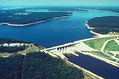
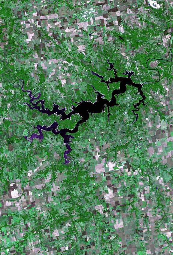
Lake and Dam Location Monroe / Ralls counties, Missouri, USA Coordinates 39°30′21″N 91°43′21″W / 39.505912°N 91.722407°WCoordinates: 39°30′21″N 91°43′21″W / 39.505912°N 91.722407°W Lake type reservoir Primary inflows Salt River Primary outflows Salt River Basin countries United States Max. length 30 miles (48 km) Max. width 1-mile (1.6 km) Surface area 18,600 acres (75 km2) Average depth 29 feet (8.8 m) Shore length1 285 miles (459 km) Surface elevation 606 feet (185 m) Settlements Florida 1 Shore length is not a well-defined measure.  Satellite photography of Mark Twain Lake
Mark Twain Lake is located in Ralls County, Missouri and Monroe County, Missouri. It was created by the Clarence Cannon Dam impounding the Salt River and is located about twenty miles (32 km) southwest of Hannibal. It was named for Missouri author Mark Twain and part of the area around it is Mark Twain State Park. The village of Florida is located next to the lake and was the site of Twain's birth.
Contents
Authorization and purpose
The Joanna Dam project was first proposed in 1937 as an answer to many years of flooding by the Salt River. With support and expertise of many, including Representative Clarence Cannon, the multi-purpose project was authorized by Congress in the Flood Control Act of October 1962. The Clarence Cannon Dam and Mark Twain Lake offer multiple benefits to Northeast Missouri including: hydroelectricity, flood Control, recreation, fish and wildlife conservation, water supply (shortage of existing ground water), navigation.[1]
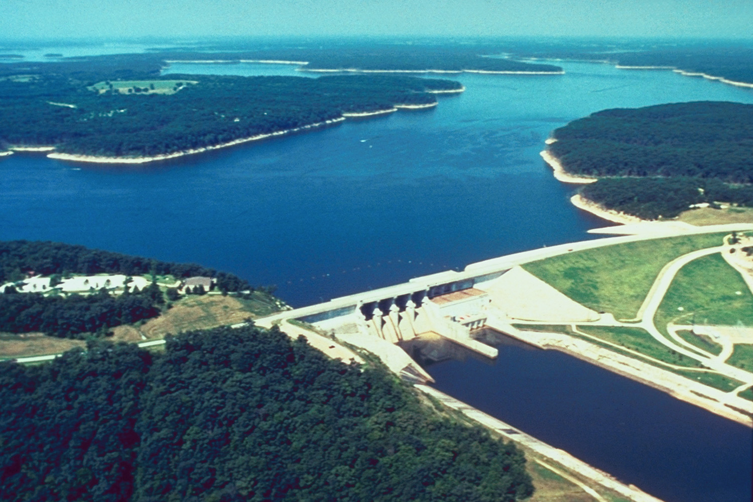
Clarence Cannon Dam and power house
Originally known as the Joanna Dam, the Clarence Cannon Dam is a 138 ft (42 m) high and 1,940 ft (590 m) long combination concrete gravity embankment dam. The dam contains 450,000 cu yd (340,000 m3) of concrete and 3,000,000 cu yd (2,300,000 m3) of earth-fill.
The Clarence Cannon Dam contains a hydroelectric power plant, with two generators, capable of producing up to 58 MW of power, or enough to supply a town of 20,000 people. When both units are operating at capacity, as much as 5,400,000 US gallons of water pass through the turbines each minute. A regulation dam, located 9.5 miles (15.3 km) downstream from the main dam, creates a storage pool that can be used for pumped-storage hydroelectricity. When demand for electricity is low, power from other sources can be used to pump water back from the tailwater to the lake. This water can then be re-cycled through the turbines when energy is in high demand.[1]
Namesakes
Clarence Cannon was one of the prime influences in the realization of the Cannon Dam Project during his 42 years serving in the U.S. House of Representatives. He was actively engaged in farming in Lincoln County throughout his life and the author of several publications on parliamentary law. Following his death in 1964, the Joanna Dam was officially renamed to honor the man who was a longtime supporter of the project.[1]
Using the pen names "Josh", "Sergeant Fathom," and "Mark Twain," Samuel Langhorne Clemens received the namesake for the lake. Although he traveled and lived in many places, Mark Twain, which literally means "two fathoms deep," often delighted audiences and readers with colorful stories of his native Missouri.[1]
Recreation
Clarence Cannon Dam and Mark Twain Lake provide opportunities for outdoor recreation - boating, swimming, fishing, picnicking, hiking and hunting. There are recreation areas equipped with facilities such as campgrounds, beaches, and picnic shelters, as well as areas that are being managed for wildlife habitat. All visitors can enjoy the 54,000 acres (220 km2) of land and water at Clarence Cannon Dam and Mark Twain Lake.[1]
Camping is available in three U.S. Army Corps of Engineers developed recreation areas, at the Mark Twain State Park and in several private recreation areas around the lake. Camping fees and facilities differ in the areas, however most have electric hookups, showers, restrooms, sanitary stations, fire grills, picnic tables and playground equipment. Group camping areas and a number of individual campsites are also available on a reservation basis. Campfire programs are held throughout the summer at outdoor amphitheaters in the campgrounds and give visitors the opportunity to learn more about the natural and cultural history of the area. School, scout and other interested groups may schedule programs upon request. The Corps also assists groups who sponsor bass tournaments, jamborees and other special events at the lake.[1]
With over 18,000 acres (73 km2) of water, Mark Twain Lake is a suitable location for any type of water recreation. Boaters can use numerous boat ramps located conveniently around the lake as well as two full service marinas. Developed beaches on the lake provide swimming conditions. Anglers will find catfish, bass, crappie, walleye, bluegill and sunfish. Timber has been left in the upper ends of the lake and in selected coves to improve fish habitat.[1]
Mark Twain Lake also provides recreational opportunities for picnickers, hikers, and hunters. Hikers and backpackers are can use the many miles of trails throughout the lake area. Wildlife blinds, food plots and small ponds enhance a hiker's chance of spotting a deer, bluebird or other wildlife inhabitants of Missouri. For hunters, there are thousands of prime hunting grounds easily accessible from hunter/fisherman parking lots located throughout the area.[1]
References
- ^ a b c d e f g h "Clarence Cannon Dam & Mark Twain Lake". Brochure. U.S. Army Corps of Engineers. http://www.mvs.usace.army.mil/MarkTwain/PDF's/MTL_Map_MTL_Overall_Map.pdf. Retrieved 12 July 2010.
Categories:- Reservoirs in Missouri
- Buildings and structures in Ralls County, Missouri
- Buildings and structures in Monroe County, Missouri
- Geography of Ralls County, Missouri
- Geography of Monroe County, Missouri
- Quincy-Hannibal Area
- Pumped storage power stations
Wikimedia Foundation. 2010.