- Orizaba, Veracruz
-
This article is about the municipality. For the article about the mountain, see Pico de Orizaba
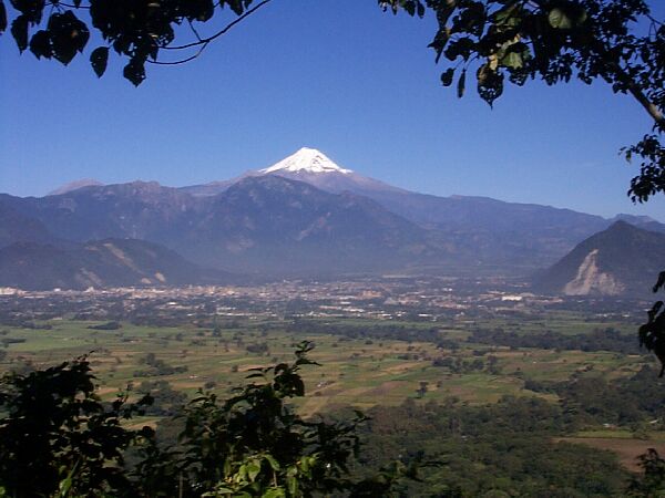
 The Orizaba Valley
Looking north, Orizaba in the middle distance, the Pico de Orizaba on the horizonOrizaba is a city and municipality in the Mexican state of Veracruz. It is located 20 km west of its sister city Córdoba, and is adjacent to Río Blanco and Ixtaczoquitlán, on Federal Highways 180 and 190. The city had a 2005 census population of 117,273 and is almost coextensive with its small municipality, with only a few small areas outside the city. The municipality's population was 117,289 and it has an area of 27.97 km² (10.799 sq mi).
Contents
Naming
It is generally understood that the name Orizaba comes from a Hispanized pronunciation of the Nahuatl name Ahuilizapan [āwil-lis-ā-pan], which means (more or less) "valley of happiness". Another possibility, however, is the word Harish (Jerez de la Frontera, Andalusia, in XVI-century Spanish pronunciation), this place being the hometown of the first Spanish settlers (1521) of Orizaba. Harish or—in a simplified form—Ariz, with the addition (under the influence of the Arabic language) of the gentilic "i" and/or with the ending "aba", meaning fortification, would have become Ariziba or Arizaba, from which Orizaba would have derived. (The word Harish—in turn—is, according to some authors, linked to the capital of Tartessus and could refer to the biblical Tarshish. Its Semitic meaning could be "trading post" or "fundry site", since Tartessus was a mayor Phoenician center of tin commerce and bronze production.) Orizaba<=Ori=Uri+zaba=Sabah=Shebah=Shiva (derived from Torah)
Geography and inhabitants
The town lies at 1,200 m. (4000 ft.), at the confluence of the Río Blanco with several tributaries, including the Río Orizaba, near the mouth of a large valley heading westward into the eastern Sierra Madre Oriental. This location, at the bottom of the ascent into the mountains, is an important transition point along what has been for centuries the main trade route between Mexico City and Veracruz on the Gulf Coast. The climate is generally pleasant, though often cloudy and rainy, and the soil of the Orizaba valley is extraordinarily fertile. Overlooking the valley from the north is the Pico de Orizaba (Citlaltépetl), a volcano that, at 5,636 m. (18,490 ft.), is the highest mountain in Mexico and third highest in North America.
 The "Palacio de Hierro"
In the town of Ixhuatlancillo north of Orizaba, and in a large mountainous area to the south (the Sierra de Zongolica), live many thousands of people who speak a variant of Nahuatl which is often called Orizaba Nahuatl [ ISO code nlv].
History
Orizaba was already an important town at the time of the Spanish conquest, and it was in Orizaba that La Malinche, Hernán Cortés's interpreter and mistress, was married to the Spanish gentleman Juan Jaramillo. A plaque in Orizaba commemorates this event.
During the colonial period, Orizaba became an important city. On January 27, 1774, the Spanish king Carlos III conceded town status (villa) to Orizaba, and on November 29, 1830 Orizaba was declared a city.
When Lucas Alamán established, in 1836, the first textile factory (Cocolapan factory) of Orizaba, the city started its economic life as an industrial city.
In 1839 the newspaper La Luz was created and the Veracruz governor Francisco Hernández y Hernández gave the name of Veracruz-Llave (remembering the General Ignacio de la Llave, who was born in Orizaba) to this state of Mexico.
On May 8, 1874, Orizaba was declared the capital city of Veracruz, but in 1878 the status was transferred to Xalapa.
During the government of Porfirio Díaz, Orizaba was declared the most educated city in the Mexican province.
In the late years of Porfirio Díaz' Government, two important workers' strikes occurred, those of Cananea and Río Blanco, the latter taking place in Orizaba and being an important prelude to the Mexican Revolution.
The American WWI and WWII transport ship USS Orizaba (ID-1536) was named after this town.
Economy
The Orizaba’s area ( including the municipalities of Ixtaczoquitlán, Río Blanco, Nogales y Cd. Mendoza) economy has grown significantly in the last years due to the safety of the area, being of great confidence for national and foreign investors who wants to establish in a safe place. Another important reason it’s the presence of recognised Universities like Universidad Veracruzana, Instituto Tecnológico de Orizaba or Instituto Tecnológico y de Estudios Superiores de Monterrey Campus Central de Veracruz en Córdoba; The industry it’s mainly focused in the following areas: Bier brewers, paper industry, cement, pharmaceutical, iron and steel sector, soft drinks and food industry, leather and shoemaker companies among others. Also in the last years the commercial area experiments a significant growth due to the opening of new Malls & Major Retailers.
Main sights
The old City Hall El Palacio de Hierro (The Iron Palace) in the centre of the city was designed by Eiffel. Built with 600 tons of Belgian steel, its parts were shipped from Austria during El Porfiriato (the government of Porfirio Díaz), to be assembled in Orizaba. The palace cost 100,000 pesos (sterling Silver) a very large sum at the time, and it was Don Manuel Carrillo Tablas who not only loaned the money to the city, but also had to pay the additional cost of unloading the palace from the port and having it reassembled at its present location, the Plaza de Armas. Unfortunately, Don Manuel Carrillo Tablas died New Year's Eve of 1899 without ever having received a cent from the city for his loan. He was a very charitable man, though, having donated the land where the present Cathedral of Orizaba now stands, as well as the adjacent shopping center known as "El Mercado." El Palacio de Hierro served as the City Hall until the city felt it was not large enough for the growing needs of the local government and therefore moved to its present location.
 Partial view of the city of Orizaba.
Orizaba has an important industrial life. There is, for example, the Cervecería Cuauhtémoc Moctezuma company (a brewery), which was established in 1896 in Orizaba.
Monuments and buildings
- The Iron Palace
- El Palacio Municipal (The City Hall)
- The Church of Nuestra Señora Del Carmen
- The Church of La Concordia
- State Art Museum
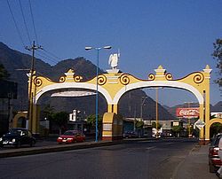 The entrance to Orizaba from Río Blanco
Notable Orizabeños (people from Orizaba)
- Sara García
- Ignacio de la Llave
- Francisco Gabilondo Soler
- Humberto Vélez
- Evita Muñoz "Chachita"
- Fernando Etienne (Actor)
- Oscar Tarrago, classical pianist
-
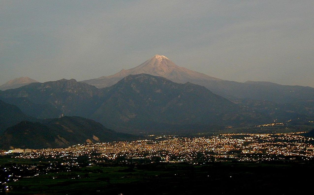
 Orizaba before dawn
References
- (Hernan Cortes, Cartas de Relacion, Madrid, Espasa-Calpe, 1940.)
- (Bernal Diaz del Castillo, Historia Verdadera de la Conquista de la Nueva España, Mexico, Pedro Robredo, 1939.)
- (Francisco Alvarez de Icaza, Diccionario Autobiografico de Conquistadores y Pobladores de la Nueva España, Madrid, Imprenta de "El Adelantado de Segovia", 1923.)
- (Victor M. Alvarez, Diccionario de Conquistadores, Mexico, D.F., INAH, 1975.)
- (Peter Boyd-Bowman, Indice Geobiografico de Mas de 56 Mil Pobladores de la America Hispanica, I: 1493-1519, Mexico, Fondo de Cultura Economica, 1985.)
- (Maria del Rosario Casellas Gonzalez, Gonzalo de Sandoval, Segundo Capitan de la Conquista de la Nueva España, Tesis, Departamento de Historia, UNAM, Mexico, 1969.)
- (Diccionario Porrua de Historia, Biografia y Geografia de Mexico, Mexico, Editorial Porrua, 1964.)
- (Enciclopedia Espasa-Calpe, Barcelona, Espasa Calpe, 1928.)
- (Enciclopedia General de Andalucia, España, C&T Editores, c.2010.)
- (Gran Enciclopedia de Andalucia, Sevilla, Promociones Culturales Andaluzas, no date.)
- (Joaquin Arroniz, Ensayo de una Historia de Orizaba --original edition from 1867--, Mexico, D.F., Fundacion Miguel Aleman, Instituto Veracruzano de la Cultura, 2004.)
- (Jose Maria Naredo, Estudio Geografico, Historico y Estadistico del Canton y de la Ciudad de Orizaba, Orizaba, Imprenta del Hospicio, 1898.)
- (Carlos Calero, Orizaba, Editorial Citlaltepetl, 1970.)
- (Ernesto Lemoine Villicaña, Documentos y Mapas para la Geografia Historica de Orizaba, 1690-1800, Mexico, D.F., Archivo General de la Nacion, 1962.)
- (Alberto Gochicoa Gomez, Las Cronicas de Orizaba, Mexico, c.2009.)
- ("Traza, ocupacion del espacio y segregacion; la morfologia urbana de Orizaba en el siglo XIX", Eulalia Ribera Carbu, in the book "De Veracruz a Puebla, un Itinerario Historico entre la Colonia y el Porfiriato", Carlos Contreras Cruz y Claudia Patricia Pardo Hernandez, editors, Instituto de Investigaciones Dr. Jose Maria Luis Mora, Mexico.)
- (Jose Antonio Calderon Quijano, Historia de las Fortificaciones en Nueva España, Madrid, Escuela de Estudios Hispanoamericanos, 1953.)
- (Sergio Florescano Mayet, El Camino Mexico-Veracruz en la Epoca Colonial, Xalapa, Centro de Investigaciones Historicas, Universidad Veracruzana, 1987.)
- (The Anchor Bible Dictionary, New York, Doubleday, 1992.)
- (Eerdmans Dictionary of the Bible, Grand Rapids, Michigan, B. Eerdmans Publishing Co., 2000.)
- (Encyclopaedia Judaica, Jerusalem, 1972.)
- (The New Encyclopaedia Britannica, 15th edition, Chicago, 1990s.)
- (Ethelia Ruiz Medrano, Gobierno y Sociedad en Nueva España.)
- (Ethelia Ruiz Medrano, Reshaping New Spain.)
- (Robert Himmerich Valencia, The Encomenderos of New Spain, 1521-1555.)
- (Alvin Eustis, Francois Chevalier, Land and Society in Colonial Mexico.)
- (John Michael Francis, Iberia and the Americas --Culture, Politics and History, Vol. 1.)
- (David Marles, Wars of the Americas --A Chronology of Armed Conflict in the New World.)
- Link to tables of population data from Census of 2005 INEGI: Instituto Nacional de Estadística, Geografía e Informática
- Veracruz Enciclopedia de los Municipios de México
External links
- Ayuntamiento Constitucional de Orizaba Official website
- Orizaba Nahuatl
- Pico de Orizaba on Bivouac
- Orizaba Regional Portal Culture, Tourism, Pictures, Maps & More.
- Museo de Arte del Estado de Veracruz Art Museum of the State of Veracruz (Only in Spanish)
Coordinates: 18°51′N 97°06′W / 18.85°N 97.1°W
Xalapa (capital) Huasteca Alta
RegionChalma · Chiconamel · Chinampa de Gorostiza · El Higo · Naranjos · Ozuluama de Mascareñas · Pánuco · Platón Sánchez · Pueblo Viejo · Tamalín · Tamiahua · Tampico Alto · Tantima · Tantoyuca · Tempoal de Sánchez
Huasteca Baja
RegionBenito Juárez · Castillo de Teayo · Cerro Azul · Chicontepec de Tejeda · Chontla · Citlaltépetl · Huayacocotla · Ilamatlán · Ixcatepec · Ixhuatlán de Madero · Tancoco · Temapache (Álamo) · Tepetzintla · Texcatepec · Tlachichilco · Tuxpan · Zacoalpan · Zontecomatlán de López y Fuentes
Totonaca
RegionCazones de Herrera · Chumatlán · Progreso de Zaragoza · Coatzintla · Coxquihi · Coyutla · Espinal · Filomeno Mata · Gutiérrez Zamora · Mecatlán · Papantla · Poza Rica · Tecolutla · Tihuatlán · Zococolco de Hidalgo
Nautla
RegionAtzalán · Colipa · Juchique de Ferrer · Martínez de la Torre · Misantla · Nautla · San Rafael · Tenochtitlán · Tlapacoyan · Vega de Alatorre · Yecuatla
Capital
RegionAcajete · Acatlán · Actopan · Alto Lucero · Altotonga · Apazapan · Ayahualulco · Banderilla · Chiconquiaco · Coacoatzintla · Coatepec · Cosautlán de Carvajal · Emiliano Zapata (Dos Ríos) · Ixhuacán de los Reyes · Jalacingo · Jalcomulco · Jilotepec de Molina Enríquez · Las Minas · Las Vigas de Ramírez · Landero y Coss · Miahuatlán · Naolinco de Victoria · Perote · Rafael Lucio · Tatatila · Teocelo · Tepetlán · Tlacolulan · Tlalnelhuayocan · Tonayán · Villa Aldama · Xalapa · Xico
Sotavento
RegionBoca del Río · Cotaxtla · Jamapa · La Antigua (José Cardel) · Manlio Fabio Altamirano · Medellín · Puente Nacional · Soledad de Doblado · Tlalixcoyan · Úrsulo Galván · Veracruz
Mountains
RegionAcultzingo · Alpatláhuac · Amatlán de los Reyes · Aquila · Astacinga · Atlahuico · Atoyac · Atzacan · Calcahualco · Camarón de Tejeda · Camerino Z. Mendoza (Ciudad Mendoza) · Carrillo Puerto (Tamarindo) · Chocamán · Coetzala · Comapa · Córdoba · Coscomatepec de Bravo · Cuichapa · Cuitláhuac · Fortín de las Flores · Huatusco · Huiloapan de Cuauhtémoc · Ixhuatlán del Café · Ixhuatlancillo · Ixtaczoquitlán · La Perla · Los Reyes · Magdalena · Maltrata · Mariano Escobedo · Mixtla de Altamirano · Naranjal · Nogales · Omealca · Orizaba · Paso del Macho · Rafael Delgado · Río Blanco · San Andrés Tenejapan · Sochiapa · Soledad Atzompa · Tehuipango · Tenampa · Tepatlaxco · Tequila · Tezonapa · Tlacotepec de Mejía · Tlaltetela · Tlaquilpa · Tlilapan · Totutla · Xoxocotla · Yanga · Zentla · Zongolica
Papaloapan
RegionAcula · Ángel R. Cabada · Alvarado · Amatitlán · Carlos A. Carrillo · Chacaltianguis · Cosamaloapan · Ignacio de la Llave · Isla · Ixmatlahuacan · José Azueta (Villa Azueta) · Juan Rodríguez Clara · Lerdo de Tejada · Otatitlán · Playa Vicente · Saltabarranca · Santiago Sochiapan (Xochiapa) · Tierra Blanca · Tlacojalpan · Tlacotalpan · Tres Valles · Tuxtilla
Los Tuxtlas
RegionCatemaco · San Andrés Tuxtla · Santiago Tuxtla · Hueyapan de Ocampo
Olmeca
RegionAcayucan · Agua Dulce · Chinameca · Coatzacoalcos · Cosoleacaque · Hidalgotitlán · Ixhuatlán del Sureste · Jáltipan · Jesús Carranza · Las Choapas · Mecayapan · Minatitlán · Moloacán · Nanchital · Oluta · Oteapan · Pajapan · San Juan Evangelista · Sayula de Alemán · Soconusco · Soteapan · Tatahuicapan · Texistepec · Uxpanapa) · Zaragoza
Categories:- Populated places in Veracruz


Wikimedia Foundation. 2010.