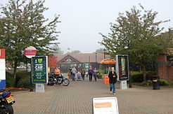
- Clacket Lane services
-
Clacket Lane Services 
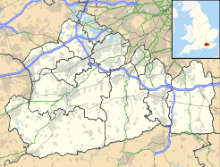
The westbound service area County Surrey Road M25 Coordinates 51°16′16″N 0°02′20″E / 51.271076°N 0.038789°ECoordinates: 51°16′16″N 0°02′20″E / 51.271076°N 0.038789°E Operator RoadChef Date opened 1993 Website RoadChef Clacket Lane services is a motorway service station on the M25 motorway in Surrey, United Kingdom that is owned by RoadChef. Services are located on either side of the motorway between Westerham, Kent and Limpsfield, Surrey.
Clacket Lane is one of the largest and busiest services on the UK motorway network serving traffic on the extremely busy southern stretch of the M25, and traffic to and from the coastal ports and the Channel Tunnel. It is named after a road called Clacket Lane, which passes over the M25 nearby.
History
The station was opened in 1993. A service station at the site was first proposed in 1972. On the first planning application the service station was to be named Titsey Wood after the forest that surrounds the site.
During construction of the site Roman artifacts were found from a roman road and are now displayed at the service station.[1] It is believed that these Roman artifacts inspired the installation of the now-famous electronic coin-operated Bocca della Verità fortune telling machine in the main lobby of the westbound service area.
References
- ^ "Clacket Lane". Motorway Services Online. http://motorwayservicesonline.co.uk/services/clacket/. Retrieved 5 January 2010.
External links
Roadchef Locations Annandale Water · Bothwell · Chester · Clacket Lane · Durham · Hamilton · Killington Lake · Maidstone · Magor · Northampton · Norton Canes · Pont Abraham · Rownhams · Sandbach · Sedgemoor (southbound) · Stafford (southbound) · Strensham · Taunton Deane · Tibshelf · Watford GapFood Franchises Retail Franchises Fuel Franchises Categories:- United Kingdom road stubs
- M25 motorway service stations
- RoadChef motorway service stations
Wikimedia Foundation. 2010.

