Mean center of United States population
- Mean center of United States population
-
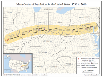
Map showing changes to the mean center of population for the United States, 1790–2010 (U.S. Census Bureau)
[1]
The mean center of U.S. population is determined by the United States Census Bureau from the results of each census. The Bureau defines it to be:
the point at which an imaginary, flat, weightless, and rigid map of the
United States would balance perfectly if weights of identical value were placed on it so that each weight represented the location of one person on the date of the census.
[2]
During the 20th century the mean center of population shifted 324 miles (521 km) west and 101 miles (163 km) south. The southerly movement was much stronger during the second half of the century; 79 miles (127 km) of the 101 miles (163 km) happened between 1950 and 2000.
The following lists location information of the mean center of U.S. population since 1790:
| US Census |
County |
Location description [3] |
decimal Coordinates [3] |
| 1790 |
Kent County, Maryland 1.) |
23 miles east of Baltimore. |
39°16′30″N 76°11′12″W / 39.27500°N 76.18667°W / 39.27500; -76.18667 |
| 1800 |
Howard County, Maryland |
18 miles west of Baltimore. |
39°16′06″N 76°56′30″W / 39.26833°N 76.94167°W / 39.26833; -76.94167 |
| 1810 |
Loudoun County, Virginia |
40 miles northwest by west of Washington, DC. |
39°11′30″N 77°37′12″W / 39.19167°N 77.62000°W / 39.19167; -77.62000 |
| 1820 |
Hardy County, Virginia (now W. Virginia) 2.) |
16 miles east of Moorefield. |
39°05′42″N 78°33′00″W / 39.09500°N 78.55000°W / 39.09500; -78.55000 |
| 1830 |
Grant County, Virginia (now W. Virginia) 2.) |
19 miles west-southwest of Moorefield. |
38°57′54″N 79°16′54″W / 38.96500°N 79.28167°W / 38.96500; -79.28167 |
| 1840 |
Upshur County, Virginia (now W. Virginia) 2.) |
16 miles south of Clarksburg. |
39°02′00″N 80°18′00″W / 39.03333°N 80.30000°W / 39.03333; -80.30000 |
| 1850 |
Wirt County, Virginia (now W. Virginia) 2.) |
23 miles southeast of Parkersburg. |
38°59′00″N 81°19′00″W / 38.98333°N 81.31667°W / 38.98333; -81.31667 |
| 1860 |
Pike County, Ohio |
20 miles south by east of Chillcothe. |
39°00′24″N 82°48′48″W / 39.00667°N 82.81333°W / 39.00667; -82.81333 |
| 1870 |
Highland County, Ohio |
48 miles east by north of Cincinnati. |
39°12′00″N 83°35′42″W / 39.20000°N 83.59500°W / 39.20000; -83.59500 |
| 1880 |
Boone County, Kentucky |
8 miles west by south of Cincinnati, OH. |
39°04′08″N 84°39′40″W / 39.06889°N 84.66111°W / 39.06889; -84.66111 |
| 1890 |
Decatur County, Indiana |
20 miles east of Columbus. |
39°11′56″N 85°32′53″W / 39.19889°N 85.54806°W / 39.19889; -85.54806 |
| 1900 |
Bartholomew County, Indiana |
6 miles southeast of Columbus. |
39°09′36″N 85°48′54″W / 39.16000°N 85.81500°W / 39.16000; -85.81500 |
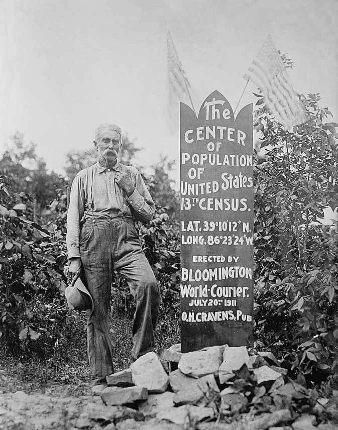
| 1910 |
Monroe County, Indiana |
in the city of Bloomington. |
39°10′12″N 86°32′20″W / 39.17000°N 86.53889°W / 39.17000; -86.53889 |
| 1920 |
Owen County, Indiana |
8 miles south-southeast of Spencer. |
39°10′21″N 86°43′15″W / 39.17250°N 86.72083°W / 39.17250; -86.72083 |
| 1930 |
Greene County, Indiana |
3 miles northeast of Linton. |
39°03′45″N 87°08′06″W / 39.06250°N 87.13500°W / 39.06250; -87.13500 |
| 1940 |
Sullivan County, Indiana |
2 miles southeast by east of Carlisle. |
38°56′54″N 87°22′35″W / 38.94833°N 87.37639°W / 38.94833; -87.37639 |
| 1950 |
Richland County, Illinois 3.) |
8 miles north-northwest of Olney. 3.) |
38°50′21″N 88°09′33″W / 38.83917°N 88.15917°W / 38.83917; -88.15917 3.) |
| 1950 |
Clay County, Illinois 4.) |
3 miles northeast of Louisville. 4.) |
38°48′15″N 88°22′08″W / 38.80417°N 88.36889°W / 38.80417; -88.36889 4.) |
| 1960 |
Clinton County, Illinois 5.) |
6-1/2 miles northwest of Centralia. 5.) |
38°35′58″N 89°12′35″W / 38.59944°N 89.20972°W / 38.59944; -89.20972 5.) |
| 1970 |
St. Clair County, Illinois |
5 miles east-southeast of Mascoutah. |
38°27′47″N 89°42′22″W / 38.46306°N 89.70611°W / 38.46306; -89.70611 |
| 1980 |
Jefferson County, Missouri |
1/4 mile west of DeSoto. |
38°08′13″N 90°34′26″W / 38.13694°N 90.57389°W / 38.13694; -90.57389 |
| 1990 |
Crawford County, Missouri |
9.7 miles southeast of Steelville. |
37°52′20″N 91°12′55″W / 37.87222°N 91.21528°W / 37.87222; -91.21528 |
| 2000 |
Phelps County, Missouri |
2.8 miles east of Edgar Springs |
37°41′49″N 91°48′34″W / 37.696987°N 91.809567°W / 37.696987; -91.809567 [4] |
| 2010 |
Texas County, Missouri |
2.7 miles northeast of Plato. |
37°31′03″N 92°10′23″W / 37.517534°N 92.173096°W / 37.517534; -92.173096 [5] |
Notes on the table data
- In the first census (1790) the mean population center was near Chestertown, Maryland.[4]
- The mean population centers of 1820, 1830, 1840 and 1850 were in what is now West Virginia, given West Virginia's split from Virginia in 1863.[4]
- Computation method used until 1950
- Current computation method
- The addition of Alaska and Hawaii to the union moved the center about two miles (3 km) farther south and about ten miles (16 km) farther west in 1960.[3]
See also
References
Wikimedia Foundation.
2010.
Look at other dictionaries:
Median center of United States population — Map showing the locations of the U.S. median center of population, 1880 2010 (U.S. Census Bureau)[1] The median center of U.S. population is determined by the United States Census Bureau from the results of each census. The Bureau defines it to… … Wikipedia
UNITED STATES OF AMERICA — UNITED STATES OF AMERICA, country in N. America. This article is arranged according to the following outline: introduction Colonial Era, 1654–1776 Early National Period, 1776–1820 German Jewish Period, 1820–1880 East European Jewish Period,… … Encyclopedia of Judaism
Demographics of the United States — As of today s date, the United States has a total resident population of 312,615,000, making it the third most populous country in the world. It is a very urbanized population, with 82% residing in cities and suburbs as of 2008 (the worldwide… … Wikipedia
1880 United States Census — The United States Census of 1880 was the tenth United States Census conducted by the Census Bureau during June 1880. [http://usa.ipums.org/usa/voliii/inst1880.shtml 1880 Census: Instructions to Enumerators] from IPUMS, a website of the Minnesota… … Wikipedia
United States — a republic in the N Western Hemisphere comprising 48 conterminous states, the District of Columbia, and Alaska in North America, and Hawaii in the N Pacific. 267,954,767; conterminous United States, 3,022,387 sq. mi. (7,827,982 sq. km); with… … Universalium
United States — This article is about the United States of America. For other uses of terms redirecting here, see US (disambiguation), USA (disambiguation), and United States (disambiguation). United States of America … Wikipedia
Center of population — with a mean distance of convert|5000|km|sigfig=1|sp=us. Its antipodal point is correspondingly the farthest point from everyone on earth, and is located in the South Pacific near 15000|km|sp=us.In demographics, the center of population of a… … Wikipedia
United States Constitution — P … Wikipedia
United States public debt — Part of a series of articles on Unit … Wikipedia
United States Congress — For the current Congress, see 112th United States Congress. United States Congress 112th United States Congress … Wikipedia

 The center of the U.S. population, 13th census (1910), near Bloomington, Indiana