- California State Route 187
-
State Route 187
Venice Boulevard 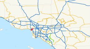
Route information Defined by S&HC § 487 Maintained by Caltrans Length: 5.405 mi[1] (8.699 km) Major junctions West end:  SR 1 in Venice
East end:  I-10 near Culver City
Highway system State highways in California(list • pre-1964)
History • Unconstructed • Deleted • Freeway • Scenic←  SR 186
SR 188  →
→State Route 187 (SR 187), known as Venice Boulevard, is an unsigned state highway in the U.S. state of California in Los Angeles County. It runs parallel to Interstate 10, connecting the cities of Santa Monica, Los Angeles and Culver City. Route 187 starts at Lincoln Boulevard (State Route 1) in Venice. The state route itself is officially discontinued for 3 miles (4.8 km); however, Venice Boulevard still physically exists. Route 187 has access to Interstate 405 via nearby Sawtelle and Sepulveda Boulevards. The state route's northeastern terminus is with Interstate 10. Venice Boulevard continues on, paralleling Interstate 10 until its intersection with South Main Street and East 16th Street in Los Angeles.
Contents
Route description
SR 187 begins at Lincoln Boulevard (SR 1) in Venice and travels northeast as Venice Boulevard. The divided highway continues into Mar Vista and goes under I-405; there are ramps nearby that connect to the freeway. East of here, SR 187 briefly forms the boundary between Palms and Culver City and passes near Sony Pictures Studios. Venice Boulevard continues northeast into the South Robertson neighborhood of Los Angeles, where the SR 187 designation terminates at the intersection with Cadillac Avenue and the ramp carrying traffic from westbound I-10.[2]
Metro Local line 33 and Metro Rapid line 733 operate on Venice Boulevard. The Metro Expo Line is proposed to serve a rail station at its intersection with Robertson Boulevard.
Venice Boulevard constitutes the border between the central portion of Los Angeles and South Los Angeles.[citation needed] Communities passed are Venice, Mar Vista, Palms, Culver City, and South Los Angeles.
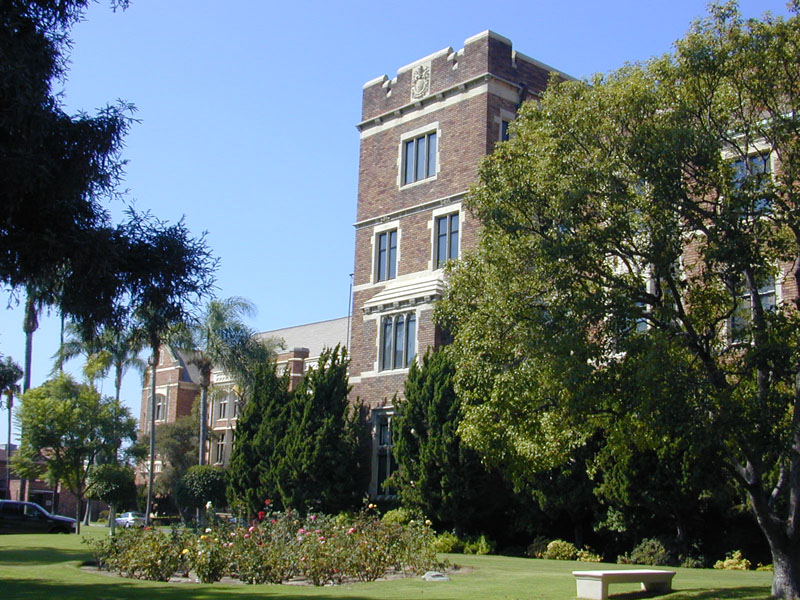
It is directly north of Washington Boulevard. Venice High School is located near the intersection with Walgrove Avenue. Loyola High School is located by Venice and Vermont Avenue.
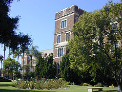 Loyola High School fronting Venice Boulevard
Major intersections
- Note: Except where prefixed with a letter, postmiles were measured in 1964, based on the alignment as it existed at that time, and do not necessarily reflect current mileage.
The entire route is in Los Angeles, Los Angeles County.
Postmile
[1][3][4]Destinations Notes 3.50 Venice Boulevard Continuation beyond SR 1 3.50 SR 1 (Lincoln Boulevard)4.78 Centinela Avenue Sawtelle Boulevard 5.83  I-405 (San Diego Freeway)
Interchange; former SR 7 5.91 Sepulveda Boulevard 6.62 Overland Avenue 7.63 Culver Boulevard Robertson Boulevard to I-10 west National Boulevard to I-10 east8.64 La Cienega Boulevard 8.80 I-10 (Santa Monica Freeway)Interchange 8.91 Cadillac Avenue, Venice Boulevard Continuation beyond I-10 1.000 mi = 1.609 km; 1.000 km = 0.621 mi References
- ^ a b California Department of Transportation, State Truck Route List (XLS file), accessed February 2008
- ^ Thomas Brothers (2008). Los Angeles County Road Atlas (Map).
- ^ California Department of Transportation, Log of Bridges on State Highways, July 2007
- ^ California Department of Transportation, All Traffic Volumes on CSHS, 2005 and 2006
External links
- California @ WestCoastRoads.com - State Route 187
- Caltrans: Route 187 highway conditions
- California Highways: SR 187
Categories:- Streets in Los Angeles County, California
- Culver City, California
- State highways in California


Wikimedia Foundation. 2010.