- Prince Rupert, British Columbia
Infobox Settlement
official_name = City of Prince Rupert
other_name =
native_name =
nickname =
settlement_type =
motto =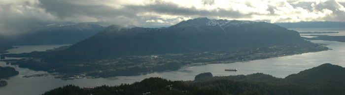
imagesize =
image_caption = Prince Rupert as seen from Mount Morse
flag_size =
image_
seal_size =
image_shield = Prince Rupert-COA.png
city_logo =
citylogo_size =
mapsize =
map_caption =
mapsize1 =
map_caption1 =
image_dot_
dot_mapsize =
dot_map_caption = Location of Prince Rupert inBritish Columbia
dot_x = 46 |dot_y = 82
pushpin_
pushpin_label_position =
pushpin_map_caption =
pushpin_mapsize =
subdivision_type = Country
subdivision_name = CAN
subdivision_type1 = Province
subdivision_name1 = BC
subdivision_type2 = Regional District
subdivision_name2 = Skeena-Queen Charlotte Regional District
subdivision_type3 =
subdivision_name3 =
subdivision_type4 =
subdivision_name4 =
government_footnotes =
government_type =
leader_title = Mayor
leader_name = Herb Pond
leader_title1 = Governing Body
leader_name1 = Prince Rupert City Council
leader_title2 = MP
leader_name2 =Nathan Cullen (NDP)
leader_title3 = MLA
leader_name3 =Gary Coons (NDP)
leader_title4 =
leader_name4 =
established_title = Incorporated
established_date = March 10, 1910
established_title2 =
established_date2 =
established_title3 =
established_date3 =
area_magnitude =
unit_pref =
area_footnotes =
area_total_km2 = 54.9
area_land_km2 =
area_water_km2 =
area_total_sq_mi =
area_land_sq_mi =
area_water_sq_mi =
area_water_percent =
area_urban_km2 =
area_urban_sq_mi =
area_metro_km2 =
area_metro_sq_mi =
area_blank1_title =
area_blank1_km2 =
area_blank1_sq_mi =
population_as_of =
population_footnotes =
population_note =
population_total = 12,815 (2006)
population_density_km2 = 233.4
population_density_sq_mi =
population_metro =
population_density_metro_km2 =
population_density_metro_sq_mi =
population_urban =
population_density_urban_km2 =
population_density_urban_sq_mi =
population_blank1_title =
population_blank1 =
population_density_blank1_km2 =
population_density_blank1_sq_mi =
timezone =Pacific Time Zone
utc_offset = -8
timezone_DST = Pacific Daylight Time
utc_offset_DST = -7
latd= 54|latm= 18|lats= 44|latNS=N
longd= 130|longm= 19|longs= 38|longEW=W
elevation_footnotes =
elevation_m = 40
elevation_ft =
postal_code_type = Postal code span
postal_code = V8J
area_code = +1-250
blank_name =
blank_info =
blank1_name =
blank1_info =
website = [http://www.princerupert.ca/ Prince Rupert.ca]
footnotes =Prince Rupert is a port city in the province of
British Columbia ,Canada . It is the land, air, and water transportation hub of British Columbia's North Coast, and home to some 12,815 people (Statistics Canada , 2006).Location
Prince Rupert is situated on
Kaien Island (approximately 770 km (480 mi) north of Vancouver), just north of the mouth ofSkeena River , and linked by a short bridge to the mainland. The city is located along the island's northwestern shore, fronting onPrince Rupert Harbour .At the western terminus of
Trans-Canada Highway 16 (theYellowhead Highway ), Prince Rupert is approximately 146 km (91 mi) west of Terrace, and 715 km (444 mi) west of Prince George.Neighbouring communities
By virtue of location, Prince Rupert is the gateway to many destinations:
* Dodge Cove (1 km, 0.6 mi, west)
* Metlakatla (5 km, 3 mi, west)
* Port Edward (15 km, 9 mi, south)
*Lax Kw'alaams (Port Simpson) (30 km, 19 mi, northwest)
* Oona River (43 km, 27 mi, southwest)
*Kitkatla (65 km, 40 mi, south)
* Kisumkalum (140 km, 87 mi, east)
* Kitselas (142 km, 88 mi, east)
* Terrace (146 km, 87 mi, east)
* Hartley Bay (157 km, 98 mi, southeast)The
Queen Charlotte Islands (also known asHaida Gwaii) are to the west of Prince Rupert, across theHecate Strait .Alaska is 49nautical mile s (90 km, 56 mi) north of Prince Rupert.History
Archaeological records and oral history suggest continuous occupation of the Prince Rupert area by the
Tsimshian First Nations people for around 4000 to 5000 years [http://www.civilisations.ca/aborig/tsimsian/vilintre.html] .Prince Rupert, named after
Prince Rupert of the Rhine , was founded byCharles Melville Hays , the general managerof theGrand Trunk Pacific Railway (GTP) and was incorporated onMarch 10 ,1910 . Prior to the opening of the GTP, the business centre on the North Coast was Port Essington on the Skeena River. After the founding of Prince Rupert at the western terminus for theGrand Trunk Pacific Railway , Port Essington returned to being a fishing community and is now a ghost town.Charles Hays had many grand ideas for Prince Rupert including berthing facilities for large passenger ships and the development of a major tourism industry. These plans fell through when Charles Hays perished
April 15 ,1912 on the RMS "Titanic".Mount Hays , the larger of two mountains on Kaien Island, is named in his honour, as is a local high school,Charles Hays Secondary School .Local politicians used the promise of a highway connected to the mainland as an incentive and the city grew over the next several decades. American troops finally completed the 100 mile stretch of road between Prince Rupert and Terrace during
World War II to facilitate the movement of thousands of allied troops to theAleutian Islands and thePacific . FollowingWorld War II , the fishing industry, particularlysalmon andhalibut , andforestry became the city's major industries. Prince Rupert was the Halibut Capital of the World until the early 1980s. A long-standing dispute over fishing rights in the Dixon Entrance to the Hecate Straight (pronounced as "hekk-et") between American and Canadian fisherman lead to the formation of the54-40 or Fight Society. TheUnited States Coast Guard maintains a military base in nearbyKetchikan, Alaska .Over the years, hundreds of students were said to have largely paid their way through school by working in the then lucrative
fishing industry. Construction of a pulp mill began in 1947 and was operating by 1951. Theconstruction ofcoal andgrain shipping terminals followed. The 1960s, 1970s and 1980s saw the construction of many amenities including acivic centre ,swimming pool ,public library ,golf course andperforming arts centre (recently renamed "The Lester Centre of the Arts"). Prince Rupert had much to offer as it transitioned from a fishing andmill town to a small city.In the 1990s, both the fishing and
forest industries experienced a significant downturn ineconomic activity. In July, 1997, Canadian fishermen blockaded theAlaska Marine Highway ferry M/V "Malaspina", keeping it in the port as a protest in thesalmon fishing rights dispute between Alaska and British Columbia. The forest industry died when the soft wood lumber dispute arose between Canada and the U.S. After the pulp mill closed down, many people were out of a job, and a significant amount of top of the line machinery was left dormant. After reaching a peak of about 18,000 in the early 1990s, Prince Rupert's population began to decline as people left in search of work.The period from 1996 to 2004 saw difficult times for Prince Rupert, including closure of the
pulp mill , the burning down of a fish plant and a significantpopulation decline. 2005 may be viewed as a critical turning point though. The announcement of the construction of acontainer port in April 2005, combined with new ownership of thepulp mill , the 2004 opening of a newcruise ship dock, the resurgence of coal and grainshipping , and the prospects of increasedheavy industry andtourism foretell a bright future for the area.On
August 22 ,1949 , a magnitude 8.1earthquake destroyed windows and buildings swung. See1949 Queen Charlotte earthquake .Population
Statistics Canada has recorded the following population counts in theircensuses. Census agglomerations are listed in parentheses.
* 2006 - 12,815 (13,392)
* 2001 - 14,643 (15,302)
* 1996 - 16,714 (17,414)
* 1991 - (17,359)Government
The current
mayor of Prince Rupert isHerb Pond . The current councillors of Prince Rupert areNelson Kinney ,Ken Cote ,Kathy Bedard ,Sheila Gordon-Payne ,Joy Thorkelson , andTony Briglio .Prince Rupert is part of the
Skeena—Bulkley Valley federal riding (electoral district).Nathan Cullen is the currentMember of Parliament for the riding, and is a member of theNew Democratic Party .In the
Legislative Assembly of British Columbia , Prince Rupert is a large portion of the North Coast riding.Gary Coons is the currentMember of the Legislative Assembly . He is a member of theNew Democratic Party of British Columbia . The NDP traditionally has strong support in the region.ignificant politicians
After 1908, Thomas Dufferin "Duff" Pattullo became mayor of Prince Rupert. He went on to become the
Premier of British Columbia from 1933-1941, as a member of the Liberal Party.Alexander Malcom Manson, the first lawyer in Prince Rupert, was elected to the BC Legislature in the riding of Omineca in 1916 as a Liberal. He became Speaker of the House in 1921 and the following year was appointed as both Attorney-General and Minister of Labour, serving in both capacities for six years. He was later appointed to the BC Supreme Court.
In 1986, NDP candidate Dan Miller was elected to the Prince Rupert Electoral District and from August of 1999 through February of 2000 was Premier.
Iona Campagnolo began her political career when she was elected to Prince Rupert City Council in 1966. In 1974, she successfully ran for the Liberal Party in the federal riding of Skeena. In 1976 she was appointed Minister of Amateur Sports. She became president of the Liberal Party of Canada in 1982. She served as British Columbia’s Lieutenant-Governor from 2001 to 2007.Industry
Prince Rupert currently relies on the fishing industry, port, and tourism; however from 1951 to 2001 Prince Rupert also benefited from the
Watson Island Pulp Mill , located less than 14 km (8 mi) outside of the city.Transport
eaport
Prince Rupert's sheltered harbour is the deepest ice-free
natural harbour inNorth America . Situated at 54° North, the harbour is the northwestern most port in North America linked to the continent's railway network. Located on theGreat Circle Route between easternAsia and western North America, the port is the first inbound and last outbound port of call forcargo ship s.Passenger ferries operating from Prince Rupert include
BC Ferries ' service to theQueen Charlotte Islands and to
Port Hardy onVancouver Island , and Alaska Marine Highway ferries to
Ketchikan, Juneau and Sitka and many other portsalong Alaska'sInside Passage . The Prince Rupert Ferry Terminal is co-located with the city's train station, from whichVIA Rail offers a thrice-weekly passenger train called "The Skeena", connecting to Prince George and Jasper, and through a connection with "The Canadian " to the rest of the continental passenger rail network.The
Prince Rupert Port Authority is responsible for the port's operation.Much of the harbour is formed by the shelter provided by Digby Island, which lies windward of the city and contains the
Prince Rupert Airport . The city is located onKaien Island and the harbour also includes Tuck Inlet, Morse Basin, Wainwright Basin, and Porpoise Harbour, as well as part of the waters of Chatham Sound which takes in Ridley Island.Port Facilities
The
Prince Rupert Port Authority (PRPA) is a federally-appointed agency which administers and operates various port properties on the harbour. Previously run by the National Harbours Board and subsequently the Prince Rupert Port Corporation, the PRPA is now a locally-run organization.PRPA port facilities include:
* Atlin Terminal
* Northlands Terminal
* Lightening Dock
* Ocean Dock
* Westview Dock
* Fairview Terminal
* Prince Rupert Grain
* Ridley Terminals
* Sulphur CorporationAll PRPA facilities are serviced by CN Rail.
The
Canadian Coast Guard maintains CCG Base Seal Cove on Prince Rupert Harbour where vessels are homeported for search and rescue and maintenance of aids to navigation throughout the north coast. CCG also bases helicopters at Prince Rupert for servicing remote locations with aids to navigation, as well as operating a Marine Communications Centre, covering a large Vessel Traffic Services zone from Port Hardy at the northern tip ofVancouver Island to the International Boundary north of Prince Rupert.Both
BC Ferries and theAlaska Marine Highway operate ferries which call at Prince Rupert, with destinations in theAlaska Panhandle , theQueen Charlotte Islands , and isolated communities along the central coast to the south.Airport
Prince Rupert Airport (YPR/CYPR) is located onDigby Island . Its position is coord|54|17|10|N|130|26|41|W, and itselevation is 35 m (116 ft [ This is a measured value in feet ] ) abovesea level . The airport comprises onerunway , one passenger terminal, and two aircraft stands. Access to the airport is typically achieved by a bus connection that departs from one location in downtown Prince Rupert (Highliner Hotel) and travels to Digby Island by ferry. The airport is served byAir Canada andHawkair fromVancouver International Airport (YVR).Prince Rupert is also served by the
Prince Rupert/Seal Cove Water Aerodrome , aseaplane facility with regularly scheduled, as well as chartered, flights to nearby villages and remote locations.Railway
A three times weekly passenger rail service known as "The Skeena" operated by
Via Rail connects Prince Rupert with Prince George and Jasper. The service takes two days and requires an overnight hotel stay in Prince George.Weather
Prince Rupert is known as "The City of Rainbows", as it is Canada's wettest city, with an average annual precipitation of approximately 2,500 mm (100 in) (
Statistics Canada , 1999). It is also regarded as the municipality in Canada which receives the least amount of sunshine annually. Winters are relatively mild for the latitude (even January does not average below freezing), although frosts and blasts of cold Arctic air from the northeast are not uncommon. Summers are relatively cool, with daytime temperatures averaging below 20°C (68°F). Wind speeds are relatively strong, with prevailing winds blowing from the southeast. There is ample precipitation throughout the year, but autumn is the wettest season. Snowfall in Prince Rupert is rare and normally melts within a few days, although individual snowstorms may bring copious amounts of snow.Tourist brochures boast about Prince Rupert's "100 days of sunshine".
Communications
Telephone, mobile, and Internet service are provided by
CityWest (formerly CityTel). CityWest is owned by the City of Prince Rupert. CityWest provides long-distance telephone service, as doesTelus .In September 2005, the city changed CityTel from a city department into an independent corporation named CityWest. The new corporation immediately purchased the local cable company,
Monarch Cable Systems , expanding CityWest's customer base to other northwestBritish Columbia communities.Since January 2008, Rogers Communications has offered
GSM and EDGE service in the area -- the first real competition to CityWest's virtual monopoly. Rogers offers local numbers based in Port Edward (prefix 600), which is in the local calling zone for the Prince Rupert area. The introduction of Rogers service forced Citywest to form a partnership withBell_Canada to bring digital services to Citywest Mobility, using CDMA.Media
Radio
* AM 560 - CHTK,
adult contemporary
* AM 860 - CFPR,CBC Radio One
* FM 100.7 - CIAJ, Christian programming
* FM 101.9 - CJFW-2,country music
* FM 98.1 -CFNR-FM , classic rock (Canada's First Nations' Radio)Television
* Channel 6 - CFTK-1,
CBC Television private affiliateTourist attractions
Prince Rupert is a central point on the Inside Passage, a route of relatively sheltered waters running along the Pacific coast from
Vancouver, British Columbia toSkagway, Alaska . It is visited by many cruise ships during the summer en route between Alaska to the north and Vancouver and theLower 48 to the south.Prince Rupert is also the starting point for many wildlife viewing trips including whales, eagles and grizzly bears. The Khutzeymateen Grizzly Bear sanctuary features one of the densest remaining populations in North America; tours can be arranged by water or air (using
float plane s) departing from Prince Rupert.Citations
The book "", written by
Sarah de Leeuw , includes an essay about Prince Rupert entitled "Highway of Monsters".Ra McGuire of the band
Trooper wrote the hit song "Santa Maria" on a boat in Prince Rupert's Harbour. Says McGuire, "The boat was called The Lucky Lady. We sailed from Prince Rupert onto an island off the coast with an awful lot of alcohol and some salmon to barbecue. Many of the lines in the song are direct quotes from the skipper. He actually said 'Okay, there's only fear and good judgment holding us back.' On the way back he said 'Does somebody know how to drive this thing?' I actually wrote these down in a little notepad as we went." [http://www.trooper.ca/default.php?cat=articles&subcat=35]Notes
ee also
*Monarchy in British Columbia
External links
* [http://www.princerupert.ca/ City of Prince Rupert]
* [http://hackingthemainframe.com/princerupert Prince Rupert Web Forum]
* [http://www.princerupertlibrary.ca/archives/ Prince Rupert City and Regional Archives]
* [http://www.princerupertchamber.ca/ Prince Rupert & District Chamber of Commerce]
* [http://www.sqcrd.bc.ca/ Skeena-Queen Charlotte Regional District]
* [http://rupertpics.com/ Prince Rupert Pictures]
* [http://www.rupertport.com/ Prince Rupert Port Authority]
* [http://www.ypr.ca/ Prince Rupert Airport]
* [http://www.nwcc.bc.ca/campuses/rupert.cfm Northwest Community College (Prince Rupert Campus)]
* [http://www.sd52.bc.ca/ School District 52 (Prince Rupert)]
* [http://www.prss.net/ Prince Rupert Secondary School]
* [http://charleshays.net/ Charles Hays Secondary School]
* [http://www.princerupertlibrary.ca/ Prince Rupert Library]
* [http://www.predc.com/ Prince Rupert Economic Development Corporation]
* [http://www.tourismprincerupert.com/ Tourism Prince Rupert]
Wikimedia Foundation. 2010.