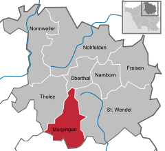
- Marpingen
-
Marpingen 
Coordinates 49°27′N 7°3′E / 49.45°N 7.05°ECoordinates: 49°27′N 7°3′E / 49.45°N 7.05°E Administration Country Germany State Saarland District Sankt Wendel Local subdivisions 4 Mayor Werner Laub (SPD) Basic statistics Area 39.68 km2 (15.32 sq mi) Elevation 301 m (988 ft) Population 10,770 (31 December 2010)[1] - Density 271 /km2 (703 /sq mi) Other information Time zone CET/CEST (UTC+1/+2) Licence plate WND Postal code 66646 Area codes 06827, 06853 Website www.marpingen.de Marpingen is a municipality in the district of Sankt Wendel , in Saarland, Germany. It is situated approx. 8 km west of Sankt Wendel, and 25 km north of Saarbrücken.
The municipality contains the urban areas Marpingen, Urexweiler, Alsweiler und Berschweiler, which have the status of Ortschaft, and Rheinstraße, which is in the administrative area of Marpingen, und Habenichts, which is in the administrative area of Urexweiler.
Contents
History
In 1876, at the height of the Kulturkampf, Marpingen was claimed to be the site of an apparition of the Virgin Mary, leading to a major conflict between the Prussian Government and the believers who flocked to Marpingen as a result.
References
- ^ "Fläche, Bevölkerung in den Gemeinden am 31.12.2010 nach Geschlecht, Einwohner je km² und Anteil an der Gesamtbevölkerung" (in German). Statistisches Amt des Saarlandes. 31 December 2010. http://www.saarland.de/dokumente/thema_statistik/staa_FB311209.pdf.
- Blackbourn, David (1994). Marpingen: Apparitions of the Virgin Mary in Nineteenth-Century Germany. New York: Alfred A Knopf. ISBN 0-679-41843-1.
External links
See also
- Marian apparitions
- Kulturkampf
Categories:- Municipalities in Saarland
- Saarland geography stubs
Wikimedia Foundation. 2010.


