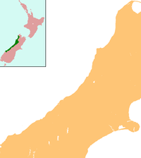
- Hokitika Airport
-
Hokitika Airport IATA: HKK – ICAO: NZHK Location of airport in West Coast Summary Airport type Public Operator Hokitika Airport Ltd Location Hokitika, New Zealand Elevation AMSL 146 ft / 45 m Coordinates 42°42′49″S 170°59′07″E / 42.71361°S 170.98528°ECoordinates: 42°42′49″S 170°59′07″E / 42.71361°S 170.98528°E Runways Direction Length Surface ft m 04/22 4,311 1,314 Asphalt 13/31 3,858 1,176 Asphalt Hokitika Aerodrome (IATA: HKK, ICAO: NZHK) is a small, uncontrolled aerodrome located 1 NM (1.9 km) north east of Hokitika on the West Coast of the South Island of New Zealand. It is also the closest domestic airport with scheduled flights to Greymouth 23 km further north, the largest settlement on the coast. The airport handles aircraft up to Bombardier Q300 types that are operated by national airline, Air New Zealand. New runway lengthening projects are underway and a new lighting system is being installed to allow the permanent use of aircraft up to ATR 72-500 size.
Airlines and destinations
Airlines Destinations Air New Zealand operated by Eagle Airways Christchurch (Up to 12 flight a week) Air New Zealand operated by Air Nelson Christchurch (Up to 6 flights a week) Operational Information
- Bitumen runway Strength: PCN 20
- Lighting
- Runway 04/22 VASIS 3 degree. caution may show reversed path above 6.5 degrees
- Wind direction indicator
- Taxiway edge
- Apron flood
- FAL
- BP Jet A1 and Avgas, swipecard.
- Shell Jet A1, carnet.
- Cafe
- Passenger
The aerodrome is operated by Hokitika Airport Ltd, +6437558123 and is available for general use without permission of the operator. The airport company is owned by the Westland District Council.
The Pavement Construction Number (PCN) is 20 which corresponds to an ability to bare aircraft up to about 84,000 lb or 38,000 kg (with tandem wheel bogies)
The runway has a landing distance of 1,314 metres, but for take off is considered to have a distance of 1,374m.
The airport has a number of car rental firms represented, and a small snack bar.
Sources
- NZAIP Volume 4 AD
- Airport information for NZHK at World Aero Data. Data current as of October 2006.
Categories:- Airports in New Zealand
- Oceanian airport stubs
- West Coast Region geography stubs
- Bitumen runway Strength: PCN 20
Wikimedia Foundation. 2010.

