- Chevening, Kent
-
Coordinates: 51°17′34″N 0°08′23″E / 51.292760°N 0.139700°E
Chevening 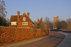
Chevening
 Chevening
Chevening shown within KentPopulation 2,762 (2001) OS grid reference TQ4857 Parish Chevening District Sevenoaks Shire county Kent Region South East Country England Sovereign state United Kingdom Post town SEVENOAKS Postcode district TN14 Dialling code 01732 Police Kent Fire Kent Ambulance South East Coast EU Parliament South East England UK Parliament Sevenoaks List of places: UK • England • Kent Chevening is a village and civil parish in the Sevenoaks District of Kent, England. The parish is located to the north west of Sevenoaks on the southern slopes of the North Downs. The parish is a small one, being 6.5 miles (10.5 km) in length and 1 mile (1.6 km) wide. It has a population of 2,762.[1] Apart from the village the remaining area is rural. Chevening House, looked after by the National Trust, is located here. The Pilgrims' Way crosses the parish. Close to Chevening, the path of Harold Godwinson's army en route to the Battle of Hastings in 1066, heading south along what is now Chipstead Lane, crosses William the Conqueror's route after the battle towards London along the Pilgrim's Way.
The village of Chevening is also small. It stands on the upper reaches of the River Darent. The village lies very close to the M25 motorway. Its parish church is dedicated to St Botolph.
Chevening was served by a railway station on the Westerham Valley Branch Line running between Westerham and Dunton Green: it opened in 1881 and closed in 1961.
References
- ^ Office for National Statistics : Census 2001 : Parish Headcounts : Sevenoaks Retrieved 18 May 2010
External links
Towns and villages in the Sevenoaks district of Kent, England 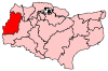 Ash · Badgers Mount · Bough Beech · Brasted · Brasted Chart · Chartwell · Chevening · Chiddingstone · Chiddingstone Causeway · Chiddingstone Hoath · Chipstead · Cowden · Crockenhill · Crockham Hill · Dunton Green · Edenbridge · Eynsford · Farningham · Fawkham · Fawkham Green · Fordcombe · Four Elms · Godden Green · Halstead · Hartley · Hever · Hextable · Hodsoll Street · Horton Kirby · Ide Hill · Kemsing · Knockholt · Leigh · Markbeech · New Ash Green · Otford · Penshurst · Ridley · Riverhead · Seal · Seal Chart · Sevenoaks · Sevenoaks Weald · Shoreham · South Darenth · Sundridge · Swanley · Swanley Village · Toys Hill · Underriver · Well Hill · Westerham · West Kingsdown
List of places in Kent Categories:- Sevenoaks
- Villages in Kent
- Civil parishes in Kent
- Kent geography stubs


Wikimedia Foundation. 2010.