- Daraa
-
This article is about the city in Syria. For the river in Morocco, see Draa River. For other uses, see Dara (disambiguation).
Daraa
درعاCoordinates: 32°37′N 36°6′E / 32.617°N 36.1°E Country  Syria
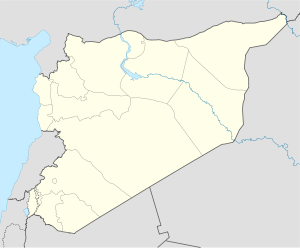
SyriaGovernorate Daraa Governorate District Daraa District Government – Governor Mohammad Khaled al-Hannus[1] Elevation 435 m (1,427 ft) Population – Total 77,203 Time zone EET (UTC+2) – Summer (DST) EEST (UTC+3) Area code(s) 15 Daraa (Arabic: درعا), also Darʿā, Dara’a, Deraa, Dera, and Derʿā ("fortress", compare Dura-Europos), is a city in southwestern Syria, near the border with Jordan, with a population of approximately 77,203.[2] It is the capital of Daraa Governorate, historically part of the ancient Hauran region. The city is located about 100 kilometres (62 mi) south of Damascus on the Damascus-Amman highway, and is used as a stopping station for travelers.
Daraa is an ancient city dating back to the Canaanites. It was mentioned in Egyptian hieroglyphic tablets at the time of the Pharaoh Thutmose III between 1490 and 1436 BC. It was known in those days as the city of Atharaa, and was later mentioned in the Old Testament as Edrei in the Kingdom of Bashan. Located in the city itself are a few ruins including caves and ancient dwellings, a Roman amphitheater, and the old Oumari Mosque which is of some architectural significance, dating back to the Umayyad and Ayyubid eras.
Daraa has recently suffered from reduced water supply in the region. Thousands of people protested in the city as part of the 2011 Syrian protests.[3]
Contents
Climate
Climate data for Dara'a Month Jan Feb Mar Apr May Jun Jul Aug Sep Oct Nov Dec Year Average high °C (°F) 13.3
(55.9)14.7
(58.5)18.0
(64.4)23.6
(74.5)28.5
(83.3)31.3
(88.3)32.6
(90.7)32.6
(90.7)31.3
(88.3)27.8
(82.0)21.0
(69.8)15.2
(59.4)24.16
(75.48)Average low °C (°F) 3.2
(37.8)4.0
(39.2)6.0
(42.8)9.3
(48.7)12.5
(54.5)15.8
(60.4)18.3
(64.9)18.6
(65.5)16.5
(61.7)12.8
(55.0)7.8
(46.0)4.6
(40.3)10.78
(51.41)Precipitation mm (inches) 60.9
(2.398)49.4
(1.945)42.3
(1.665)15.2
(0.598)3.4
(0.134)1.0
(0.039)0
(0)0
(0)0.4
(0.016)9.4
(0.37)22.9
(0.902)45.9
(1.807)250.8
(9.874)Avg. precipitation days 10 11 7 4 1 0 0 0 0 2 5 8 48 Source: World Meteorological Organization 2011 uprising
See also: Siege of DaraaThe city of Daraa was the starting point of the 2011 uprising against the regime lead by Bashar Al-Assad. It all started when 15 children from the same family (Al-Abazeed) were arrested in early March 2011 for writing an anti regime slogan on the wall of their school. The children's ages ranged between 9 and 15 years. After attempts to negotiate the release of the children were rejected by the local government, a few hundred protesters gathered in front of Oumari Mosque on March 15, 2011 calling for reforms and end of corruption. Soon after the gathering increased in size and it is reported that over 3000 people protested on the first day. This protest was faced with Syrian security forces opening fire on the protesters killing 4 people[4].
Since then, the city of Daraa and the surrounding villages have had daily protests. Which lead to several waves of major crack downs on the city which started on March 23 with invading the Oumari mosque which was being used as a field hospital for the injured during the protests. In early April, the Syrian Army's fourth fleet lead by Maher Al-Assad (Bashar's younger brother) surrounded the area of Oumari mosque shelling neighborhoods with heavy artillery.
It is reported that over 500 civilians have been killed in Daraa since the start of the uprising.
Notes
- ^ "Syria protest town 'has new governor'". France 24. 4 April 2011. http://www.france24.com/en/20110404-syria-protest-town-has-new-governor. Retrieved 6 April 2011.
- ^ http://www.world-gazetteer.com/wg.php?x=1&men=gpro&lng=en&des=wg&geo=-202&srt=npan&col=abcdefghinoq&msz=1500&pt=c&va=&geo=441489610
- ^ "Syria to free child prisoners". Al Jazeera. 20 Mar 2011. http://english.aljazeera.net/news/middleeast/2011/03/2011320113138901721.html. Retrieved 20 Mar 2011.
- ^ http://www.bbc.co.uk/news/world-middle-east-12791738
Further reading
- T.E. Lawrence, (various editions) Seven Pillars of Wisdom, Chapter LXXX
- J.G. Schumacher,(1886) Across the Jordan, pp. 1–148;
External links
- Official Site of Daraa Governorate (Arabic)
- s:Encyclopaedia Biblica/Ecclesiasticus-Eglon (king)#EDREI
Coordinates: 32°37′31″N 36°6′22″E / 32.62528°N 36.10611°E
Cities of Syria Governorate capitals Aleppo · Damascus · Daraa · Deir ez-Zor · Hama · Al-Hasakah · Homs · Idlib · Latakia · Quneitra · Ar-Raqqah · As-Suwayda · Tartus
District capitals 'Ayn al-'Arab · Abu Kamal · Afrin · Al-Bab · Al-Haffah · Al-Malikiyah · Al-Mukharram · Al-Qamishli · Al-Qusayr · Al-Qutayfah · Al-Nabk · Arihah · Al-Rastan · Al-Safirah · Al-Sanamayn · Al-Suqaylabiyah · Ash-Shaykh Badr · Al-Tall · Al-Thawrah · A'zāz · Baniyas · Darayya · Duma · Duraykish · Fiq · Harem · Afrin · Jableh · Jableh · Jarabulus · Jisr ash-Shugur · Ma'arrat al-Numan · Manbij · Al-Qutayfah · Al-Nabk · Arihah · Al-Rastan · Al-Safirah · Al-Sanamayn · Al-Suqaylabiyah · Masyaf · Mayadin · Mhardeh · Qardaha · Palmyra · Ra's al-'Ayn · Safita · Salamiyah · Salkhad · Shahba · Tal Abyad · Talkalakh · Yabrud · ZabadaniOthers Al-Darbasiyah · Al-Hajar al-Aswad · Binnish · Bosra · Dair Atiah · Harasta · Jaramanah · Kafr Nabl · Khan Shaykhun · Ma'arrat Misrin · Nawa · Salqin · Saraqib · SaidnayaDaraa Governorate Cities 

Towns and villages Categories:- Populated places in Daraa Governorate
- Fertile Crescent
- Syria geography stubs
Wikimedia Foundation. 2010.

