Mayadin — Original name in latin Maydn Name in other language Al Mayadin, Al Maydn, Al Mayadeen, Audattha, Mayadin, Mayadine, Maydn, Meyadin, Meyadine, Meyedine, Meydn, myadyn State code SY Continent/City Asia/Damascus longitude 35.02089 latitude 40.45346… … Cities with a population over 1000 database
Mayadin District — (Arabic: منطقة الميادين) is a Syrian district (mantiqah) administratively belonging to Deir ez Zor Governorate. Its capital city is the city of Mayadin. Syria Daerezzor ALMAYADIN Buqrus TAHTANI … Wikipedia
Al-Mayadin — arabisch الميادين, DMG al Mayādīn Al Mayadin … Deutsch Wikipedia
Mintaqat al Mayadin — Admin ASC 2 Code Orig. name Minţaqat al Mayādīn Country and Admin Code SY.07.173481 SY … World countries Adminstrative division ASC I-II
Phoolan Devi — Member of Parliament (11th Lok Sabha) In office 1996–1998 Constituency Mirzapur … Wikipedia
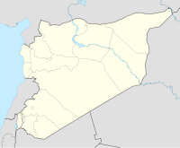
Deir ez-Zor Governorate — مُحافظة دير الزور Governorate Map of Syria with Deir ez Zor highlighted … Wikipedia
Dair az-Zaur (Gouvernement) — Die Lage der Provinz Dair az Zaur (arabisch دير الزور, DMG Dair az Zaur) ist ein Gouvernement im Osten Syriens mit einer Fläche von 33.060 km² und geschätzten 1,5 Mio Einwohnern. Sie liegt in der syrischen Wüste und grenzt im Osten an den Irak … Deutsch Wikipedia
SY-DY — Die Lage der Provinz Dair az Zaur (arabisch دير الزور, DMG Dair az Zaur) ist ein Gouvernement im Osten Syriens mit einer Fläche von 33.060 km² und geschätzten 1,5 Mio Einwohnern. Sie liegt in der syrischen Wüste und grenzt im Osten an den Irak … Deutsch Wikipedia
List of cities in Syria — Syria has fourteen governorates, or muhafazat (singular: muhafazah). According to the Central Bureau of Statistics of Syria, there are sixty districts, or manatiq (sing. mintaqah) in Syria, which are further divided into 206 subdistricts, or… … Wikipedia
Deir ez-Zor — Deyr redirects here. For the administrative subdivision of Iran, see Deyr County. Coordinates: 35°20′N 40°9′E / 35.333°N 40.15°E / 35.333; 40.15 … Wikipedia
 Mayadin
 Syria
Syria

