- Georgia State Route 54
Infobox road
state=GA
type=
route=54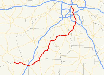
length_mi=74
length_ref=http://www.dot.state.ga.us/DOT/plan-prog/transportation_data/400reports/2002/dpp444_2002.pdf]
length_round=0
established=
direction_a=South
direction_b=North
starting_terminus=
junction=Hogansville, Peachtree City, Fayetteville, Jonesboro, Atlanta
ending_terminus= in southwest Atlanta
previous_route=53
next_route=55State Route 54 starts at U.S. 27/S.R. 1 in Troup County and ends in southwest Atlanta, as University Avenue, at the
Downtown Connector (I-75/I-85).In Clayton County, S.R. 54 (known as Jonesboro Road) passes by
Southlake Mall (Atlanta) , a very busy shopping mall.In Peachtree City, S.R. 54 is known as Floy Farr Parkway.
The southern end of State Route 54 from U.S. Route 27 to Hogansville was previously numbered State Route 258 until
1963 -1964 . [http://www.geocities.com/garoadwarrior76/garoutelog241_260.html Accessed January 23, 2007]References
Wikimedia Foundation. 2010.