- Hogansville, Georgia
Infobox Settlement
official_name = Hogansville, Georgia
other_name =
native_name =
nickname =
settlement_type =City
motto =
imagesize =
image_caption =
flag_size =
image_
seal_size =
image_shield =
shield_size =
image_blank_emblem =
blank_emblem_type =
blank_emblem_size =
imagesize =
image_caption =
flag_size =
image_
seal_size =
image_shield =
shield_size =
image_blank_emblem =
blank_emblem_type =
blank_emblem_size =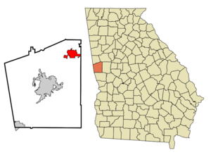
mapsize = 250px
map_caption = Location in Troup County and the state of Georgia
mapsize1 =
map_caption1 =
image_dot_
dot_mapsize =
dot_map_caption =
dot_x =
dot_y =
pushpin_
pushpin_label_position =
pushpin_map_caption =
pushpin_mapsize =
subdivision_type = Country
subdivision_name =United States
subdivision_type1 = State
subdivision_name1 = Georgia
subdivision_type2 = County
subdivision_name2 = Troup
subdivision_type3 =
subdivision_name3 =
subdivision_type4 =
subdivision_name4 =
government_footnotes =
government_type =
leader_title =
leader_name =
leader_title1 =
leader_name1 =
leader_title2 =
leader_name2 =
leader_title3 =
leader_name3 =
leader_title4 =
leader_name4 =
established_title =
established_date =
established_title2 =
established_date2 =
established_title3 =
established_date3 =
area_magnitude =
unit_pref = Imperial
area_footnotes =
area_total_km2 = 17.3
area_land_km2 = 17.2
area_water_km2 = 0.1
area_total_sq_mi = 6.6
area_land_sq_mi = 6.6
area_water_sq_mi = 0
area_water_percent =
area_urban_km2 =
area_urban_sq_mi =
area_metro_km2 =
area_metro_sq_mi =
area_blank1_title =
area_blank1_km2 =
area_blank1_sq_mi =
population_as_of = 2000
population_footnotes =
population_note =
population_total = 2774
population_density_km2 = 160.3
population_density_sq_mi = 420.3
population_metro =
population_density_metro_km2 =
population_density_metro_sq_mi =
population_urban =
population_density_urban_km2 =
population_density_urban_sq_mi =
population_blank1_title =
population_blank1 =
population_density_blank1_km2 =
population_density_blank1_sq_mi =
timezone = Eastern (EST)
utc_offset = -5
timezone_DST = EDT
utc_offset_DST = -4
latd = 33 |latm = 10 |lats = 12 |latNS = N
longd = 84 |longm = 54 |longs = 33 |longEW = W
elevation_footnotes =
elevation_m = 217
elevation_ft = 712
postal_code_type =ZIP code
postal_code = 30230
area_code = 706
blank_name = FIPS code
blank_info = 13-39244GR|2
blank1_name = GNIS feature ID
blank1_info = 0315520GR|3
website =
footnotes =Hogansville is a city in Troup County, Georgia,
United States . The population was 2,774 at the 2000 census. Hogansville holds an annual Hummingbird Festival in October. 2008 will be the 11th year of the festival.Geography
Hogansville is located at coor dms|33|10|12|N|84|54|33|W|city (33.170022, -84.909146)GR|1.
According to the
United States Census Bureau , the city has a total area of 6.7 square miles (17.3 km²), of which, 6.6 square miles (17.2 km²) of it is land and 0.04 square miles (0.1 km²) of it (0.45%) is water.Brief History
Before the Civil War
The town of Hogansville has a unique beginning in that it arose from the pre-
Civil War plantation of one man,William Hogan . Hogansville began because there was a crossroads on Hogan's land of two important routes, the north-south railroad between Atlanta and West Point, and the east-west road to Augusta, now Highway 100. In his grant of right-of-way, Hogan gave an additional convert|150|ft|m at the crossroad with the stipulation that a depot be built there. His foresight in this grant was the beginning of the town, long before it was incorporated in 1870. This depot was along the rebuilt, and has since been restored.When Hogan settled the land after the State Land Grant of 1826, he built a log home somewhere near the location of the Mill on South 29. In 1851 he built a 2 1/2 story brick colonial house. The home burned in 1899 and was rebuilt nearby in 1901. Currently Fair Oaks, a private residence at 703 East Main Street, occupies the site. William Hogan died at 57 after having 6 children by his first wife Mary and 15 by his second wife Suzanna. Because of this, his descendants are numerous with many still living in the area. William Hogan is buried in the small family cemetery in front of 705 East Main Street.
After the Civil War
Hogan sold very little of his land prior to the Civil War. The survivors of the War returned to a very grave economic situation. Reconstruction days began and John Pullin, Hogan's son-in-law, had the town laid out in business lots which were sold at an Administrators sale in 1866. Main Street was laid off in the sale sixty feet wide extending east and west on both sides of the railroad. The town of Hogansville was incorporated on October 12, 1870 and immediately was known as a center of commerce and the largest
cotton market in the area.By 1890, the Zachry Building was constructed at the corner of Main and College. The Zachry Brothers store occupied the first floor and sold general merchandise including liquor by the bottle and by the drink. Some years later, the Opera House opened on the second floor. Around 1900 the Grand Hotel was built by a stock company on the southeast corner of Main and Oak Streets. In those days old Bill Dukes and his
Ox cart met every train to bring up baggage to the Hotel. He also rang the dinner bell as he walked the length of the two porches, upstairs and downstairs shouting, "Dinner is served!" The porches extended all across the front and sides of the building on two floors. This hotel is still standing and has been restored.Turn of the Century
For much of its existence Hogansville was a
mill town . In 1897 businessmen from Atlanta and Hogansville chartered the Hogansville Manufacturing Company. The mill was built nearYellow Jacket Creek . Adjacent to the mill, a "mill village " was constructed to house the workers. This village is bounded by Green, Dickinson, Askew and Johnson Streets. In 1905 the mill was bought by Consolidated Duck ofDelaware . In 1913 Lockwood-Green ofBoston . Callaway of LaGrange bought the mill in 1928, and finally the company that was to becomeUniroyal bought the mill and operated it until recently. Currently the mill operates asIndustrial Specialty Fabrics .Great Depression
With the
Great Depression and the dramatic fall of cotton prices, Hogansville fell on hard economic times during the 20's and 30's. The town did benefit from many of the programs of the Roosevelt Administration. The WPA helped to build the gymnasium and tennis courts at the school on Main Street and the CCC built the Hogansville Amphitheater using stone from a nearby rock quarry. Since a recent restoration, theamphitheater is the sight of many local events including a series of concerts given during the Hummingbird Festival.Hogansville also had ties to Roosevelt on a more personal level. Mr. Hugh Darden owned the Ford dealership in town. Chief salesman Joe Broome sold to FDR the hand controller car he drove while in
Warm Springs, Georgia . The car is now on display at theLittle White House .Post War and Contemporary
The period after
World War II and through theKorean War brought great prosperity to the town of Hogansville. It was the commercial center for northern Troup County, Heard, and Meriwether Counties and southern Coweta County. Main Street was abuzz with activity and the sidewalks were choked with shoppers every Saturday. In 1937 the Royal Theater was built by Mr. O.C. Lam. His brother, Mr. C.O. Lam was superintendent of schools at the time. This Theater, an excellent example ofArt Deco style was the center of social life in Hogansville for decades.With the coming of the mass use of automobiles in the 1950s, dark clouds were gathering for Hogansville. The car allowed people to travel farther and farther to larger stores and the local merchants suffered. The 60's brought social upheaval to Hogansville along with the rest of the country. When faced with the choice of integrating or closing their schools, those in favor of maintaining schools prevailed and the schools were integrated almost without incident. Current times see Hogansville looking to the future and re-establishing itself as a cultural and artistic center as well as becoming a bedroom community for the region. [Brief History excerpted from "History of the Town of Hogansville," by Jane Strain]
Attractions and Events
*
Hogansville Hummingbird Festival , outdoor arts-and-crafts festival held the third weekend of October
*Christmas Parade, "Santa Claus and dozens of floats, both home-made and professional, our parade is small town life at its best" ["Hogansville, Georgia" pamphlet]
*Trunk or Treat, "A great Hogansville Halloween idea. Fun for kids of all ages. Proves the adage that it's better to give than receive." ["Hogansville, Georgia" pamphlet]
*Van Byars Antique Auction, a Hogansville tradition, every third Saturday throughout the yearDemographics
As of the
census GR|2 of 2000, there were 2,774 people, 1,099 households, and 727 families residing in the city. Thepopulation density was 418.1 people per square mile (161.3/km²). There were 1,249 housing units at an average density of 188.2/sq mi (72.6/km²). The racial makeup of the city was 55.16% White, 43.22% African American, 0.18% Native American, 0.47% Asian, 0.29% from other races, and 0.68% from two or more races. Hispanic or Latino of any race were 0.58% of the population.There were 1,099 households out of which 29.7% had children under the age of 18 living with them, 39.2% were married couples living together, 22.6% had a female householder with no husband present, and 33.8% were non-families. 31.4% of all households were made up of individuals and 16.7% had someone living alone who was 65 years of age or older. The average household size was 2.49 and the average family size was 3.11.
In the city the population was spread out with 27.9% under the age of 18, 8.4% from 18 to 24, 25.3% from 25 to 44, 22.1% from 45 to 64, and 16.3% who were 65 years of age or older. The median age was 37 years. For every 100 females there were 82.0 males. For every 100 females age 18 and over, there were 77.7 males.
The median income for a household in the city was $27,976, and the median income for a family was $32,979. Males had a median income of $27,028 versus $18,889 for females. The
per capita income for the city was $12,592. About 10.2% of families and 12.6% of the population were below thepoverty line , including 16.4% of those under age 18 and 13.9% of those age 65 or over.References
External links
* [http://www.cityofhogansville.org/ Official City of Hogansville Site]
* [http://www.hummingbirdfestival.com/ Hogansville Hummingbird Festival]
* [http://www.campground.flatcreek.us/ Flat Creek Campground, Hogansville]
* [http://www.vanbyarsauction.com/ Van Byars Auction]
Wikimedia Foundation. 2010.