- Quasi-Zenith Satellite System
-
The Quasi-Zenith Satellite System (QZSS), is a proposed three-satellite regional time transfer system and Satellite Based Augmentation System for the Global Positioning System, that would be receivable within Japan. The first satellite 'Michibiki' was launched on 11 September 2010.[1] Full operational status is expected by 2013.[2][3]
Authorized by the Japanese government in 2002, work on a concept for a Quasi-Zenith Satellite System (QZSS), or Juntencho (準天頂) in Japanese, began development by the Advanced Space Business Corporation (ASBC) team, including Mitsubishi Electric Corp., Hitachi Ltd., and GNSS Technologies Inc. However, ASBC collapsed in 2007. The work was taken over by the Satellite Positioning Research and Application Center. SPAC is owned by four departments of the Japanese government, the Ministry of Education, Culture, Sports, Science and Technology; of Internal Affairs and Communications,; of Economy, Trade and Industry; and the Ministry of Land, Infrastructure and Transport.[4]
QZSS is targeted at mobile applications, to provide communications-based services (video, audio, and data) and positioning information. With regards to its positioning service, QZSS can only provide limited accuracy on its own and is not currently required in its specifications to work in a stand-alone mode. As such, it is viewed as a GNSS Augmentation service. Its positioning service could also collaborate with the geostationary satellites in Japan's Multi-Functional Transport Satellite (MTSAT), currently under development, which itself is a Satellite Based Augmentation System similar to the U.S. Federal Aviation Administration's Wide Area Augmentation System (WAAS).
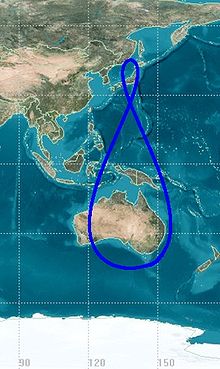
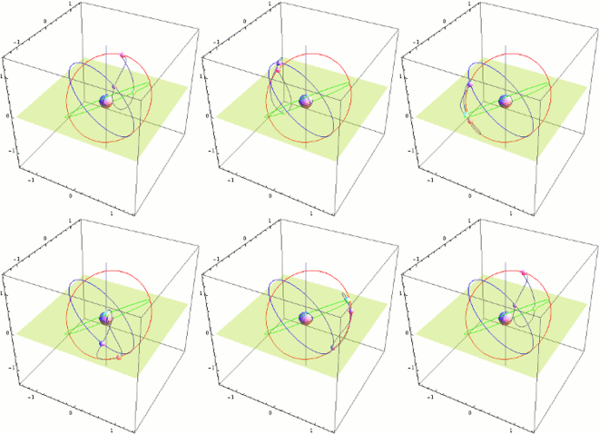
The satellites would be placed in a periodic Highly Elliptical Orbit (HEO). These orbits allow the satellite to dwell for more than 12 hours a day with an elevation above 70° (meaning they appear almost overhead most of the time) and give rise to the term "quasi-zenith" for which the system is named. Similar orbits are used by the Sirius Satellite Radio system (Tundra orbit). As of June 2003, the proposed orbits ranged from 45° inclination with little eccentricity, to 53° with significant eccentricity.
Contents
QZSS and positioning augmentation
QZSS can enhance GPS services in two ways: first, availability enhancement, whereby the availability of GPS signals is improved, second, performance enhancement whereby the accuracy and reliability of GPS derived navigation solutions is increased.
Because the GPS availability enhancement signals transmitted from Quasi-Zenith Satellites are compatible with modernized GPS signals, and hence interoperability is ensured, the QZSs will transmit the L1C/A signal, L1C signal, L2C signal and L5 signal. This minimizes changes to specifications and receiver designs.
Compared to standalone GPS, the combined system GPS plus QZSS delivers improved positioning performance via ranging correction data provided through the transmission of submeter-class performance enhancement signals L1-SAIF and LEX from QZS. It also improves reliability by means of failure monitoring and system health data notifications. QZSS also provides other support data to users to improve GPS satellite acquisition.
According to its original plan, QZSs was to carry two types of space-borne atomic clocks; a hydrogen maser and a Rb atomic clock. The development of a passive hydrogen maser for QZSs was abandoned in 2006. The positioning signal will be generated by a Rb clock and an architecture similar to the GPS timekeeping system will be employed. QZSS will also be able to use a Two-Way Satellite Time and Frequency Transfer (TWSTFT) scheme, which will be employed to gain some fundamental knowledge of satellite atomic standard behavior in space as well as for other research purposes.
QZSS timekeeping and remote synchronization
Although the first generation QZSS timekeeping system (TKS) will be based on the Rb clock, the first QZS, will carry a basic prototype of an experimental crystal clock synchronization system. During the first half of the two year in-orbit test phase, preliminary tests will investigate the feasibility of the atomic clock-less technology which might be employed in the second generation QZSS.
The mentioned QZSS TKS technology is a novel satellite timekeeping system which does not require on-board atomic clocks as used by existing navigation satellite systems such as GPS, GLONASS or the planned GALILEO system. This concept is differentiated by the employment of a synchronization framework combined with lightweight steerable on-board clocks which act as transponders re-broadcasting the precise time remotely provided by the time synchronization network located on the ground. This allows the system to operate optimally when satellites are in direct contact with the ground station, making it suitable for a system like the Japanese QZSS. Low satellite mass and low satellite manufacturing and launch cost are significant advantages of this novel system. An outline of this concept as well as two possible implementations of the time synchronization network for QZSS were studied and published in Fabrizio Tappero's PhD work.[5]
See also
References
- ^ "Launch Result of the First Quasi-Zenith Satellite 'MICHIBIKI' by H-IIA Launch Vehicle No. 18". http://www.jaxa.jp/press/2010/09/20100911_h2af18_e.html.
- ^ "QZSS in 2010". Magazine article. Asian Surveying and Mapping. 2009-05-07. http://www.asmmag.com/news/qzss-in-2010. Retrieved 2009-05-07.
- ^ The System. GPS World Online, November 2007. Retrieved 6 Dec 07.
- ^ "Service Status of QZSS". 2008-12-12. http://www.aprsaf.org/data/aprsaf15_data/csawg/CSAWG_6d.pdf. Retrieved 2009-05-07.
- ^ "Remote Synchronization Method for the Quasi-Zenith Satellite System: study of a novel satellite timekeeping system which does not require on-board atomic clocks". 2008-12-12. http://www.amazon.com/Remote-Synchronization-Method-Quasi-Zenith-Satellite/dp/3639160045/ref=sr_1_1?ie=UTF8&s=books&qid=1280310101&sr=8-1. Retrieved 2009.
- Quasi-Zenith Satellites System.
- High Accuracy Positioning Experiment System Using Quasi-Zenith Satellites System (JAXA)(Japanese)
- Petrovski, Ivan G. QZSS - Japan's New Integrated Communication and Positioning Service for Mobile Users. GPS World Online. June 1, 2003.
- Kallender-Umezu, Paul. Japan Seeking 13 Percent Budget Hike for Space Activities.] Space.com. September 7, 2004.
- QZSS / MSAS Status Kogure, Satoshi. Presentation at the 47th Meeting of the Civil Global Positioning System Service Interface Committee (CGSIC). September 25, 2007.
External links
- JAXA Quasi-Zenith Satellite-1 "MICHIBIKI"
- JAXA MICHIBIKI Special Site
- JAXA MICHIBIKI data site
- Twitter (Japanese)
Global navigation satellite systems Historical Operational Developmental GNSS augmentation Related topics Japanese space program Organizations Weather observation CompletedHimawari (1 · 2 · 3 · 4 · 5)In operationIn orbitPlannedHimawari-8 · Himawari-9Earth observation CompletedIn operationPlannedCommunications,
broadcasting and
positioningCompletedSakura (1 · 2a · 2b · 3a · 3b) · Yuri (1 · 2a · 2b · 3a · 3b) · BS(2X · 3H · 3N) · Kakehashi · Superbird (A · A1 · B1 · A2) · JCSAT(1・2・3・R) · N-STAR (a · b) · Kirari · MBSatIn operationPlannedQZSS (QZS-2 · QZS-3) · B-SAT(3c) · JCSAT(12 · 110R · 13)Engineering tests CompletedIn operationPlannedPETSAT · SDS-4CancelledSmartSat-1Private miniaturized satellites CompletedIn operationPlannedWNI satellite · Horyu (1 · 2) · SPROUT · PROITERES · TSUBAME · QSAT-EOS · SOMESAT · RAIKO · FITSAT1 · WE WISHAstronomical observation CompletedIn operationPlannedUnmanned lunar and
planetary explorationCompletedIn operationAkatsuki · IKAROSFailedNozomi · Shin'enPlannedCancelledReconnaissance CompletedIn operationIGS (Optical 1 · Optical 2 · Optical 3 · Optical 4)PlannedIGS (Experimentally Optical 5 · Optical 5 · Optical 6 · Rader 3 · Rader 4 · Rader 5 · Rader 6)Human spaceflight CompletedH-II Transfer Vehicle (1 · 2)In operationPlannedItalics indicates projects in development. Superscripts indicate joint development with1NASA, 2ESA, 3ASI, 4CSA, 5RKA, 6AEB and 7INPE. Categories:- Satellite navigation systems
- Japanese space program
Wikimedia Foundation. 2010.


