- Moosonee Airport
-
Moosonee Airport 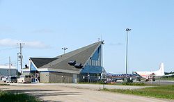
IATA: YMO – ICAO: CYMO
– WMO: 71398Summary Airport type Public Operator The Corporation of the Town of Moosonee Location Moosonee, Ontario Elevation AMSL 30 ft / 9 m Coordinates 51°17′31″N 080°36′30″W / 51.29194°N 80.60833°WCoordinates: 51°17′31″N 080°36′30″W / 51.29194°N 80.60833°W Map Location in Ontario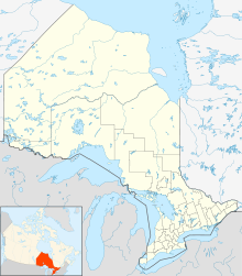
 CYMO
CYMORunways Direction Length Surface ft m 06/24 4,004 1,220 Asphalt 14/32 3,554 1,083 Gravel/Asphalt Statistics (2010) Aircraft movements 23,981 Source: Canada Flight Supplement[1]
Environment Canada[2]
Movements from Statistics Canada.[3]Moosonee Airport, (IATA: YMO, ICAO: CYMO), is located 2 NM (3.7 km; 2.3 mi) north-east of Moosonee, Ontario, Canada.
The Moosonee Airport was officially opened in May 1970 and a new terminal building was constructed in July 1991,[4] that houses the airport management office and washrooms. There are several small buildings and hangars at the airport. There are no other facilities at the airport.
The airport handles propeller or turbro prop aircraft only.
Contents
Airlines
- Air Creebec (Attawapiskat, Fort Albany, Kashechewan, Kingston, Peawanuck, Timmins, Waskaganish)[5]
- Wabusk Air (Air Ambulance, cargo, charter service)[6]
Tenants
- CHC Helicopter for Ontario Air Ambulance
See also
References
- ^ Canada Flight Supplement. Effective 0901Z 20 October 2011 to 0901Z 15 December 2011
- ^ Synoptic/Metstat Station Information
- ^ Total aircraft movements by class of operation
- ^ "Moosonee Community Profile". Wakenagun Community Futures Development Corporation. http://www.wakenagun.ca/Adobe/moosonee.pdf. Retrieved 2010-12-22.
- ^ Air Creebec
- ^ Wabusk Air
www.moosoneeairport.com
External links
- Past three hours METARs, SPECI and current TAFs for Moosonee Airport from NAV CANADA as available.
Airports in Canada By name A–B · C–D · E–G · H–K · L–M · N–Q · R–S · T–ZBy location indicator CA · CB · CC · CD · CE · CF · CG · CH · CI · CJ · CK · CL · CM · CN · CO · CP · CR · CS · CT · CV · CW · CY · CZBy province/territory National Airports System Calgary · Charlottetown · Edmonton · Fredericton · Gander · Halifax · Iqaluit · Kelowna · London · Moncton · Montréal-Mirabel · Montréal-Trudeau · Ottawa · Prince George · Québec · Regina · Saint John · St. John's · Saskatoon · Thunder Bay · Toronto · Vancouver · Victoria · Whitehorse · Winnipeg · YellowknifeRelated List of airports by ICAO code: C · List of defunct airports in Canada · List of heliports in Canada · List of international airports in Canada · National Airports System · Operation Yellow Ribbon Category ·
  Portal ·
  WikiProjectCategories:
- Airports in Ontario
- Transportation in Cochrane District, Ontario
- Ontario airport stubs


Wikimedia Foundation. 2010.