- Entrada Sandstone
-
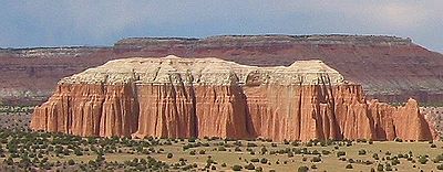
The Entrada Sandstone is a formation in the San Rafael Group that is spread across the U.S. states of Wyoming, Colorado, northwest New Mexico, northeast Arizona and southeast Utah. Part of the Colorado Plateau, this formation was deposited during the Jurassic period sometime between 180 and 140 million years ago in various environments, including: tidal mudflats, beaches and sand dunes.
Contents
Age and history of investigation
This formation has been dated to the early to middle Callovian stage of the latest Middle Jurassic.[1] The type locality and place for which the unit is named is Entrada Point, located in the northern part the San Rafael Swell in Emery County, Utah.[2]
Entrada Sandstone was named as one of the four formations of the San Rafael Group by Gilluly and Reeside in 1928. Gregory and Moore worked out the geographic extent of the formation and gave an overview of it in 1931. The extent was revised several times afterwards (most recently in 1992 by Condon). It was divided into Gunsight Butte, Cannonville, and Escalante members by Thompson and Stokes in 1970. The principal reference for the formation was written in 1988 by Peterson.
Members
Entrada members are (in alphabetical order):[1]
- Cannonville Member (UT),
- Cow Springs Member (AZ),
- Dewey Bridge Member (CO, UT) - named after the type locality at Dewey Bridge. This brick-red layer has a blocky look to it.
- Escalante Member (UT),
- Henrieville Member (UT),
- Exeter Member (NM),
- Gunsight Butte Member (UT),
- Iyanbito Member (NM),
- Moab Member (CO, UT) or Moab Tongue (CO, UT) - named after the type locality of Moab, Utah. The whitish sands from inland dunes make up this "cap rock" layer, as seen atop Delicate Arch and Broken Arch in Arches National Park.
- Red Mesa Member (AZ, NM, UT),
- Slick Rock Member (CO, UT) - named for the type locality at Slick Rock, Colorado; Rounded beach sands were cemented together to create this uniform layer.
Places found
Entrada Sandstone is found in these geologic locations:[1]
- Anadarko Basin
- Black Mesa Basin
- Denver Basin
- Great Basin province
- Green River Basin
- Las Vegas-Raton Basin
- Paradox Basin
- Piceance Basin
- Plateau sedimentary province
- San Juan Basin
- Sierra Grande Uplift
Found in these parklands (incomplete list):
- Arches National Park
- Capitol Reef National Park
- Goblin Valley State Park
- Kodachrome Basin State Park
Spatial distribution:
- spatial distribution of Entrada Sandstone in Macrostrat
References
Works cited
- Condon, S.M., 1992, "Geologic framework of pre-Cretaceous rocks in the Southern Ute Indian Reservation and adjacent areas, southwestern Colorado and northwestern New Mexico, IN Geology and mineral resources of the Southern Ute Indian Reservation", U.S. Geological Survey Professional Paper, 1505-A, p. A1-A56
- Gilluly, James and Reeside, J.B., Jr., 1928, "Sedimentary rocks of the San Rafael Swell and some adjacent areas in eastern Utah, IN Shorter contributions to general geology", 1927: U.S. Geological Survey Professional Paper, 150-D, p. D61-D110
- Gregory, H.E. and Moore, R.C., 1931, "The Kaiparowits region, a geographic and geologic reconnaissance of parts of Utah and Arizona", U.S. Geological Survey Professional Paper, 164, 16 p.
- Peterson, Fred, 1988, "Stratigraphy and nomenclature of Middle and Upper Jurassic rocks, western Colorado Plateau, Utah and Arizona, IN Revisions to stratigraphic nomenclature of Jurassic and Cretaceous rocks of the Colorado Plateau", U.S. Geological Survey Bulletin, 1633-B, p. B13-56
- Thompson, A.E. and Stokes, W.L., 1970, "Stratigraphy of the San Rafael Group, southwest and south central Utah", Utah Geological and Mineral Survey Bulletin, no. 87, 53 p.
- USGS GEOLEX database entry for Entrada Sandstone Accessed 18 March 2006 (public domain text)
Notes
Categories:- Sandstone
- Geologic formations of the United States
- Geology of Utah
- Geology of Wyoming
- Geology of Colorado
- Geology of New Mexico
- Geology of Arizona
- Jurassic geologic formations

Wikimedia Foundation. 2010.