- New Jersey Route 109
-
Route 109
Route information Maintained by NJDOT and Cape May County Length: 3.06 mi[1] (4.92 km) Existed: 1970s – present Major junctions South end:  CR 633 in Cape May
 G.S. Pkwy. in Lower Township
North end:  US 9 in Lower Township
Highway system New Jersey State Highway Routes
Interstate and US←  Route 101
Route 120  →
→←  CR 632
CR 634  →
→Route 109 is a 3.06-mile (4.92 km) state highway located in Cape May County, New Jersey, United States. The route runs from Jackson Street in Cape May north to an intersection with U.S. Route 9 in Lower Township. It crosses one of two road bridges over the Cape May Canal (the other is Route 162) and provides access to the southern end of the Garden State Parkway and County Route 621 (Ocean Drive) as well as to Cape May. Only the section of road in Lower Township is state maintained; the rest is maintained by Cape May County and signed as County Route 633, which extends 0.34 mi (0.55 km)[2] past the southern terminus along Jackson Street and Perry Street to County Route 626 in West Cape May.
Present-day Route 109 was designated as a part of pre-1927 Route 14 in 1917 before becoming the southernmost portion of Route 4 in 1927. By the 1940s, U.S. Route 9 extended south to Cape May from Absecon along this part of Route 4. In 1953, the Route 4 designation was dropped from this segment of road to avoid the concurrency with U.S. Route 9. In the 1970s, U.S. Route 9 was rerouted to head to the Cape May – Lewes Ferry terminal and continue south to Laurel, Delaware, with the former alignment into Cape May becoming Route 109.
Contents
Route description
 Route 109 entering Lower Township.
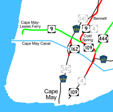
Route 109 begins at an intersection with County Route 633 in Cape May, heading to the northeast on Lafayette Street, a two-lane undivided road that is county-maintained and signed as a part of County Route 633, which itself extends past the southern terminus of Route 109 along Jackson Street and Perry Street to County Route 626 in West Cape May. The route passes through residential and commercial areas of Cape May, intersecting the northern terminus of County Route 653.[1][3] At the intersection with Sidney Avenue, Route 109 splits into a one-way pair that has two lanes in each direction, with the northbound direction following Sidney Avenue east before turning north on Washington Street and the southbound direction remaining on Lafayette Street.[3] Along this pairing, northbound Route 109 intersects the northern terminus of County Route 622.[1] A short distance later, Washington Street turns west to join Lafayette Street, ending the one-way pair, and the route heads north as a two-lane undivided road.[3]
It crosses a body of water onto an island in Lower Township. Here, the route becomes maintained by the New Jersey Department of Transportation and signed as Route 109, continuing north past several marinas and other resort businesses.[1][3] The road briefly widens into a four-lane divided highway before the median ends and it crosses over the Cape May Canal on a bridge. Upon crossing the canal, Route 109 becomes a divided highway again and intersects County Route 621 (Ocean Drive).[1] From here, the road passes a mix of homes and businesses before intersecting the southern terminus of the Garden State Parkway at an at-grade intersection.[3] At this point, the route turns to the west and becomes a two-lane undivided road and heads through woods and marshland with some residences. Route 109 heads into residential neighborhoods before it ends at an intersection with U.S. Route 9, which continues north on the road past this intersection as well as west along Sandman Boulevard toward the Cape May-Lewes Ferry terminal.[1][3]
History
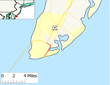
 Route 109 is an old alignment of Route 4 (U.S. Route 9) into Cape May; only the part shown in red is state maintained.
The road that is now Route 109 was legislated as a part of pre-1927 Route 14 in 1917, a route that was to run from Cape May to Egg Harbor City along what is now Route 109, U.S. Route 9 and Route 50.[4] In the 1927 New Jersey state highway renumbering, this portion of pre-1927 Route 14 became the southernmost part of Route 4, a route that was to run from Cape May north to the George Washington Bridge.[5][6] By the 1940s, U.S. Route 9 was extended south from Absecon to Cape May, running concurrent with Route 4.[7][8] In the 1953 New Jersey state highway renumbering, which eliminated long concurrencies between U.S. and state routes, the Route 4 designation was dropped along this portion of road, leaving U.S. Route 9 as the sole designation.[9][10] U.S. Route 9 was rerouted to the Cape May – Lewes Ferry and extended to U.S. Route 13 in Laurel, Delaware, in the 1970s, with Route 109 designated along the former alignment of U.S. Route 9 into Cape May.[11][12]
Major intersections
The entire route is in Cape May County.
Location Mile[1] Destinations Notes Cape May 0.00 CR 633 south (Jackson Street)Southern terminus Lower Township 2.04 
 CR 621 / Ocean Drive north
Southern terminus of CR 621 2.31 G.S. Pkwy. northGSP exit 0 3.06 US 9 (Sandman Boulevard)Northern terminus 1.000 mi = 1.609 km; 1.000 km = 0.621 mi See also
 U.S. Roads portal
 New Jersey portal
References
- ^ a b c d e f g "Route 109 straight line diagram" (PDF). New Jersey Department of Transportation. http://www.state.nj.us/transportation/refdata/sldiag/00000109__-.pdf. Retrieved 2009-08-11.
- ^ "Cape May County 633 straight line diagram" (PDF). New Jersey Department of Transportation. http://www.state.nj.us/transportation/refdata/sldiag/05000633__-.pdf. Retrieved 2009-08-12.
- ^ a b c d e f Google, Inc. Google Maps – overview of New Jersey Route 109 (Map). Cartography by Google, Inc. http://maps.google.com/maps?f=d&source=s_d&saddr=jackson+street+and+lafayette+street+cape+may,+nj&daddr=route+9+and+route+109+cape+may,+nj&hl=en&geocode=&mra=ls&sll=38.948179,-74.9103&sspn=0.006909,0.013754&ie=UTF8&t=h&z=13. Retrieved 2009-08-11.
- ^ Williams, Jimmy and Sharon. "NJ 1920s Route 14". 1920s New Jersey Highways. http://www.jimmyandsharonwilliams.com/njroads/1920s/route14.htm. Retrieved 2009-02-18.
- ^ State of New Jersey, Laws of 1927, Chapter 319.
- ^ Williams, Jimmy and Sharon. "1927 New Jersey Road Map". 1920s New Jersey Highways. Archived from the original on October 31, 2007. http://web.archive.org/web/20071031111034/http%3A//www.jimmyandsharonwilliams.com/njroads/1920s/images/1927_routes.gif. Retrieved 2008-10-08.
- ^ Williams, Jimmy and Sharon. "1927 Tydol Trails Map - South". 1920s New Jersey Highways. http://www.jimmyandsharonwilliams.com/njroads/1920s/maps/1927tt2.jpg. Retrieved 2009-03-30.
- ^ Mid-West Map Co. (1941). Map of Pennsylvania and New Jersey (Map). Cartography by H.M. Gousha. http://www.mapsofpa.com/roadcart/1941_1467m.jpg. Retrieved 2009-03-29.
- ^ 1953 renumbering. New Jersey Department of Highways. http://en.wikisource.org/wiki/1953_New_Jersey_state_highway_renumbering. Retrieved July 31, 2009
- ^ "New Road Signs Ready in New Jersey". The New York Times. December 16, 1952. http://img123.imageshack.us/img123/6933/19521216newroadsignsreaiu6.jpg. Retrieved 2009-07-20.
- ^ Esso (1970). Map of New Jersey (Map). Cartography by General Drafting.
- ^ Exxon (1976). Delaware, Maryland, Virginia, West Virginia (Map). Cartography by General Drafting.
External links
Categories:- State highways in New Jersey
- U.S. Route 9
- Intracoastal Waterway
- Transportation in Cape May County, New Jersey


Wikimedia Foundation. 2010.