- 1985 Pacific typhoon season
Infobox hurricane season
Basin=WPac
Year=1985
Track=1985 Pacific typhoon season summary.jpg
First storm formed=January 6
Last storm dissipated=December 24
Strongest storm name=Dot
Strongest storm winds=150
Strongest storm pressure=897
Total storms=26
Total hurricanes=17
Total intense=1
Fatalities=1255
five seasons=1983 1984 1985 1986 1987The 1985 Pacific typhoon season has no official bounds; it ran year-round in 1985, but mosttropical cyclones tend to form in the northwesternPacific Ocean between May and November. [Gary Padgett. [http://www.typhoon2000.ph/garyp_mgtcs/may03sum.txt May 2003 Tropical Cyclone Summary.] Retrieved2006-08-26 .] These dates conventionally delimit the period of each year when most tropical cyclones form in the northwesternPacific Ocean .The scope of this article is limited to the Pacific Ocean, north of the equator and west of the
international date line . Storms that form east of the date line and north of the equator are called hurricanes; see1985 Pacific hurricane season . Tropical Storms formed in the entire west pacific basin were assigned a name by theJoint Typhoon Warning Center . Tropical depressions in this basin have the "W" suffix added to their number. Tropical depressions that enter or form in the Philippine area of responsibility are assigned a name by thePhilippine Atmospheric, Geophysical and Astronomical Services Administration or PAGASA. This can often result in the same storm having two names.torms
27 tropical depressions formed this year in the Western Pacific, of which 26 became tropical storms. 17 storms reached typhoon intensity, of which 1 reached super typhoon strength.
Tropical Storm Elsie
infobox hurricane small
name=Tropical Storm Elsie
category=storm
type=tropical storm
track=Elsie 1985 track.pngJanuary 6
dissipated=January 9
highest winds=40 knots (1-min)
lowest pressure=995 mbarGuam . Elsie formed from the eastern circulation, appearing southwest ofPohnpei onJanuary 4 . OnJanuary 5 , further convective development occurred which formed a low level circulation onJanuary 6 . Becoming a tropical depression late that day and a tropical storm onJanuary 7 , the system moved northwest, reaching its peak intensity late in the day. Thereafter, strong southerly winds aloft arrested development, and weakening began. Tropical depression status was regained onJanuary 8 , and its circulation dissipated earlyJanuary 9 . [Joint Typhoon Warning Center. [https://metocph.nmci.navy.mil/jtwc/atcr/1985atcr/pdf/wnp/01w.pdf Tropical Storm Elsie.] Retrieved on2007-02-04 .]Tropical Storm Fabian
infobox hurricane small
name=Tropical Storm Fabian
category=storm
type=tropical storm
track=Fabian Pacific 1985 track.pngJanuary 09
dissipated=January 13 ,1985
highest winds=65 mph [https://metocph.nmci.navy.mil/jtwc/atcr/1985atcr/pdf/1985.html 1985 ATCR TABLE OF CONTENTS ] ]
lowest pressure=989 mbar [https://metocph.nmci.navy.mil/jtwc/atcr/1985atcr/pdf/1985.html 1985 ATCR TABLE OF CONTENTS ] ]
total da
total fatalities=None
hurricane season=1985 Pacific typhoon seasonTyphoon Gay
infobox hurricane small
name=Typhoon Gay
category=cat3
type=TY
track=Gay 1985 track.pngMay 20
dissipated=May 26
highest winds=100 knots (1-min)
lowest pressure=951 mbarMay 16 , a strong atmospheric circulation formed 380nautical miles (700 km) west ofKoror , now part ofPalau . The circulation began to develop convection and byMay 20 had organized into a depression. Heading north, the storm took two days to gain tropical storm strength, likely because aTUTT (Tropical Upper Tropospheric Trough) was so close to the north, restricting outflow. However, the trough soon weakened and outflow improved and the storm began to intensify faster. Gay became a typhoon early onMay 23 , continuing to intensify, Gay came under influence of a frontal boundary to the northwest and began to recurve to the northeast, through a weakness in the subtropical ridge created by the trough associated with the frontal boundary. This trough began to build and dig southeastward, pouring fuel into Gay's engine. Typhoon Gay reached its peak intensity of 100 knots (115 mph, 185 km/h) onMay 24 . As Gay started to suck in cool air, it began to weaken. Gay underwent extratropical transition as it interacted with the frontal boundary. Gay became extratropical shortly after weakening to a tropical storm early onMay 26 .Typhoon Hal
infobox hurricane small
name=Typhoon Hal
category=cat3
type=typhoon
track=Hal 1985 track.png
formed=June 19
dissipated=June 25
highest winds=100 knots (1-min)
lowest pressure=942 mbarJune 19 east of thePhilippines , passed just north ofLuzon on the 22nd as a convert|95|mi/h|km/h|abbr=on typhoon. After briefly weakening Hal restrengthened to a peak of convert|115|mi/h|km/h|abbr=on before weakening back to a minimal typhoon. The convert|75|mi/h|km/h|abbr=on typhoon hit convert|75|nmi|km east-southeast ofHong Kong in southeasternChina on the 24th, and dissipated the next day. Heavy rain associated with the typhoon caused 38 deaths (with 14 missing) and widespread crop and structural damage. [Joint Typhoon Warning Center. [https://metocph.nmci.navy.mil/jtwc/atcr/1985atcr/pdf/wnp/05w.pdf Typhoon Hal.] Retrieved on2007-01-19 .]Typhoon Irma
infobox hurricane small
name=Typhoon Irma
category=cat2
type=typhoon
track=Irma 1985 track.png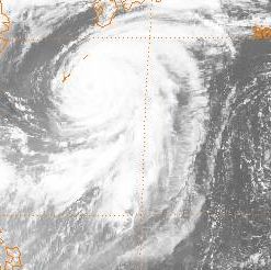
formed=June 25
dissipated=July 1
highest winds=90 knots (1-min)
lowest pressure=957 mbarJune 17 , the tropical disturbance moved westward for the next several days without significant development. As it turned northwest onJune 25 , the system strengthened rapidly into a tropical storm, reaching typhoon intensity onJune 27 as it turned more poleward. The system recurved just offshore the southern islands of Japan before striking southwest ofTokyo, Japan as a typhoon onJuly 1 . Weakening as it acclerated northeast, Irma regained tropical storm intensity later that day and became anextratropical cyclone that night. As Irma passed to the east of the Philippines the system enhanced the Monsoon Trough causing heavy rains over Luzon Island. 46 people were killed and 1,500 homes were destroyed. In Japan Irma killed 3 people and left 5 missing. [Joint Typhoon Warning Center. [https://metocph.nmci.navy.mil/jtwc/atcr/1985atcr/pdf/wnp/06w.pdf Typhoon Irma.] Retrieved on2007-01-19 .]Typhoon Jeff
infobox hurricane small
name=Typhoon Jeff
category=cat1
type=typhoon
track=Jeff 1985 track.png
formed=July 22
dissipated=August 2
highest winds=75 knots (1-min)
lowest pressure=967 mbarGuam onJuly 21 . It tracked northward, becoming a tropical storm on the 22nd and reaching its first peak of convert|70|mi/h|km/h|abbr=on winds on the 23rd. An upper level trough outran the system, forcing Jeff westward into a shearing environment and weakening it to a depression on the 26th. The shear abated, and Jeff was able to restrengthen, becoming a storm on the 27th and a typhoon on the 29th. The convert|85|mi/h|km/h|abbr=on typhoon hit eastern China on the 30th. Jeff weakened rapidly to a depression, but upon reaching theYellow Sea , it again restrengthened to a tropical storm on the 1st. Jeff reached a third peak of convert|60|mi/h|km/h|abbr=on winds before becoming extratropical on the 2nd. 180 people were killed from this storm, with moderate to heavy damage to crops. [Joint Typhoon Warning Center. [https://metocph.nmci.navy.mil/jtwc/atcr/1985atcr/pdf/wnp/07w.pdf Typhoon Jeff.] Retrieved on2007-01-19 .]Typhoon Kit
infobox hurricane small
category=cat2
type=typhoon
name=Typhoon Kit
track=Kit 1985 track.pngAugust 2
dissipated=August 11
highest winds=85 knots (1-min)
lowest pressure= 959 mbarAugust 2 . The storm continued its steady northwest motion and its steady intensification. The depression became Tropical Storm Kit onAugust 4 and didn't slow. The storm became a typhoon as it made a temporary jog to the north before continuing its northwest motion. The typhoon, small in size, reached its peak intensity of 85 knots (90 mph, 157 km/h) while south ofKyūshū onAugust 8 . Kit recurved in theEast China Sea in the face of an approaching trough through a weakness in the subtropical ridge. Kit made landfall on the southwestern tip ofSouth Korea as a borderline typhoon. Despite its weakened state, it killed ten people and caused significant property damage in the area of landfall. Kit dropped heavy rains on Cheju Island and the southern coast of South Korea. Flooding killed 10 people. Kit continued to weaken and became extratropical in theSea of Japan .Tropical Storm Lee
infobox hurricane small
name=Tropical Storm Lee
category=storm
type=tropical storm
track=Lee 1985 track.png
formed=August 11
dissipated=August 14
highest winds=60 knots (1-min)
lowest pressure=980 mbarmonsoon trough , and was initially influenced by Kit to its north. Kit's movement to the north reoriented the trough into a more north-south orientation, and a broad circulation formed 890 km south ofOkinawa . Moving north-northeast, convection around the system began to organize into a more consolidated tropical storm. The system turned northwest, but development was halted by northerly verticalwind shear . Its circulation center remained fairly broad while it continued to deepen, more like a monsoon depression than a tropical cyclone. As the system passed close to Okinawa, winds remained fairly light. However, winds increased as it pulled away, due to the pressure gradient/strongest winds being well removed from the center. Continuing to move north into a break in thesubtropical ridge , Lee moved through theEast China Sea to about 445 km west ofKyūshū and stayed about 220 km offshore the westernKorean peninsula . By this time, the system was evolving into a more typicaltropical cyclone , with stronger winds closer to the center. Accelerating across theYellow Sea onAugust 14 , Lee began to recurve acrossNorth Korea and subsequently weakened rapidly across the mountainous terrain. [Joint Typhoon Warning Center. [https://metocph.nmci.navy.mil/jtwc/atcr/1985atcr/pdf/wnp/09w.pdf Tropical Storm Lee.] Retrieved on2007-01-19 .]Typhoon Mamie
infobox hurricane small
name=Typhoon Mamie
category=cat1
type=typhoon
track=Mamie 1985 track.png
formed=August 16
dissipated=August 20
highest winds=70 knots (1-min)
lowest pressure=975 mbarAugust 15 a tropical depression formed from the monsoon trough a short distance of northernTaiwan . It headed northeastward, becoming a tropical storm later that day. The building of thesubtropical ridge to its east forced Mamie northwestward, where it became a typhoon on the 17th. On the 18th, the typhoon hit nearShanghai, China , and paralleled the east coast of China. The storm turned to the northeast, hit nearDairen, China , and dissipated on the 20th. Mamie was responsible for 35 fatalities and heavy crop damage. [Joint Typhoon Warning Center. [https://metocph.nmci.navy.mil/jtwc/atcr/1985atcr/pdf/wnp/10w.pdf Typhoon Mamie.] Retrieved on2007-01-19 .]Typhoon Nelson
infobox hurricane small
name=Typhoon Nelson
category=cat2
type=typhoon
track=Nelson 1985 track.png
formed=August 17
dissipated=August 24
highest winds=95 knots (1-min)
lowest pressure=961 mbarAugust 16 , brushed northern Taiwan on the 23rd as a convert|90|mi/h|km/h|abbr=on typhoon. Later that day, it made landfall on eastern China, and it dissipated on the 24th. Nelson caused 52 deaths and heavy damage across eastern China. In addition, the remnants of the storm stalled over the area, killing an additional 147 people. [Joint Typhoon Warning Center. [https://metocph.nmci.navy.mil/jtwc/atcr/1985atcr/pdf/wnp/11w.pdf Typhoon Nelson.] Retrieved on2007-01-19 .]Typhoon Odessa
infobox hurricane small
name=Typhoon Odessa
category=cat2
type=typhoon
track=Odessa 1985 track.png
formed=August 23
dissipated=September 1
highest winds=90 knots (1-min)
lowest pressure=957 mbarAugust 23 through the 1st of September in the WesternPacific Ocean .Odessa was one of three tropical cyclones to exist in the area of Japan at around the same time. Odessa and Pat would pass very close together with Ruby impactingTokyo . Odessa formed from an area of disturbed weather that persisted on the eastern end of a monsoon trough. The disturbance organized into a depression onAugust 23 and continued to develop and it was a tropical storm before the day was over. Odessa assumed a northerly track as it continued to strengthen, reaching typhoon intensity late onOctober 24 . Odessa had become a compact storm with a very symmetrical structure. Its eye was very well defined, despite its peak intensity of 90 knots (100 mph, 165 km/h). Odessa was observed by STS 51 as they passed overhead. Odessa was one of the most powerful, circulartropical cyclone patterns ever seen by spacecraft crew. After moving westward and stalling southwest of Japan, it turned the northeast, travelling along the southwestern coast of Japan, weakening along the way, before becoming extratropical onSeptember 1 . [Joint Typhoon Warning Center. [http://metocph.nmci.navy.mil/jtwc/atcr/1985atcr/pdf/wnp/12w.pdf Typhoon Odessa.] Retrieved on2007-01-10 .]Typhoon Pat
infobox hurricane small
name=Typhoon Pat
category=cat2
type=TY
track=Pat 1985 track.pngAugust 27
dissipated=September 01 ,1985
highest winds=110 mph [https://metocph.nmci.navy.mil/jtwc/atcr/1985atcr/pdf/1985.html 1985 ATCR TABLE OF CONTENTS ] ]
lowest pressure=961 mbar [https://metocph.nmci.navy.mil/jtwc/atcr/1985atcr/pdf/1985.html 1985 ATCR TABLE OF CONTENTS ] ]
total da
total fatalities=None
hurricane season=1985 Pacific typhoon seasonAugust 27 . Pat quickly was upgraded to tropical storm status and was named. Due to a probable Fujiwara Interaction between Pat and Typhoon Odessa, Pat moved toward the northeast. Just before making a turn towards the northwest Pat was upgraded to a typhoon on the 28th. Typhoon Pat began to accelerate in the direction ofJapan . Pat made landfall on southernKyūshū Island on the 30th before accelerating through theSea of Japan and turning extratropical. Pat killed 23 people throughKyūshū andHokkaidō and destroyed 3,000 homes. [Joint Typhoon Warning Center. [http://metocph.nmci.navy.mil/jtwc/atcr/1985atcr/pdf/wnp/20w.pdf Typhoon Pat.] Retrieved on2007-12-19 .]Tropical Storm Ruby
infobox hurricane small
name=Tropical Storm Ruby
category=storm
type=tropical storm
track=Ruby 1985 track.pngAugust 28
dissipated=September 01 ,1985
highest winds=65 mph [https://metocph.nmci.navy.mil/jtwc/atcr/1985atcr/pdf/1985.html 1985 ATCR TABLE OF CONTENTS ] ]
lowest pressure=982 mbar [https://metocph.nmci.navy.mil/jtwc/atcr/1985atcr/pdf/1985.html 1985 ATCR TABLE OF CONTENTS ] ]
total da
total fatalities=None
hurricane season=1985 Pacific typhoon seasonTyphoon Skip
infobox hurricane small
name=Typhoon Skip
category=cat1
type=TY
track=Skip 1985 track.pngAugust 30
dissipated=September 08 ,1985
highest winds=95 mph [https://metocph.nmci.navy.mil/jtwc/atcr/1985atcr/pdf/1985.html 1985 ATCR TABLE OF CONTENTS ] ]
lowest pressure=974 mbar [https://metocph.nmci.navy.mil/jtwc/atcr/1985atcr/pdf/1985.html 1985 ATCR TABLE OF CONTENTS ] ]
total da
total fatalities=None
hurricane season=1985 Pacific typhoon seasonTyphoon Tess
infobox hurricane small
name=Typhoon Tess
category=cat1
type=TY
track=Tess 1985 track.pngSeptember 01
dissipated=September 06 ,1985
highest winds=85 mph [https://metocph.nmci.navy.mil/jtwc/atcr/1985atcr/pdf/1985.html 1985 ATCR TABLE OF CONTENTS ] ]
lowest pressure=85 mbar [https://metocph.nmci.navy.mil/jtwc/atcr/1985atcr/pdf/1985.html 1985 ATCR TABLE OF CONTENTS ] ]
total da
total fatalities=None
hurricane season=1985 Pacific typhoon seasonTropical Storm Val
infobox hurricane small
name=Tropical Storm Val
category=storm
type=tropical storm
track=Val 1985 track.pngSeptember 15
dissipated=September 18 ,1985
highest winds=50 mph [https://metocph.nmci.navy.mil/jtwc/atcr/1985atcr/pdf/1985.html 1985 ATCR TABLE OF CONTENTS ] ]
lowest pressure=992 mbar [https://metocph.nmci.navy.mil/jtwc/atcr/1985atcr/pdf/1985.html 1985 ATCR TABLE OF CONTENTS ] ]
total da
total fatalities=None
hurricane season=1985 Pacific typhoon seasonTropical Storm Winona
infobox hurricane small
name=Tropical Storm Winona
category=storm
type=tropical storm
track=Winona 1985 track.pngSeptember 19
dissipated=September 22 ,1985
highest winds=60 mph [https://metocph.nmci.navy.mil/jtwc/atcr/1985atcr/pdf/1985.html 1985 ATCR TABLE OF CONTENTS ] ]
lowest pressure=990 mbar [https://metocph.nmci.navy.mil/jtwc/atcr/1985atcr/pdf/1985.html 1985 ATCR TABLE OF CONTENTS ] ]
total da
total fatalities=None
hurricane season=1985 Pacific typhoon seasonTyphoon Andy
infobox hurricane small
name=Typhoon Andy
category=cat1
type=TY
track=Andy 1985 track.pngSeptember 28
dissipated=October 02 ,1985
highest winds=80 mph [https://metocph.nmci.navy.mil/jtwc/atcr/1985atcr/pdf/1985.html 1985 ATCR TABLE OF CONTENTS ] ]
lowest pressure=970 mbar [https://metocph.nmci.navy.mil/jtwc/atcr/1985atcr/pdf/1985.html 1985 ATCR TABLE OF CONTENTS ] ]
total da
total fatalities=None
hurricane season=1985 Pacific typhoon seasonTyphoon Brenda
infobox hurricane small
name=Typhoon Brenda
category=cat2
type=TY
track=Brenda 1985 track.pngSeptember 29
dissipated=October 05 ,1985
highest winds=105 mph [https://metocph.nmci.navy.mil/jtwc/atcr/1985atcr/pdf/1985.html 1985 ATCR TABLE OF CONTENTS ] ]
lowest pressure=964 mbar [https://metocph.nmci.navy.mil/jtwc/atcr/1985atcr/pdf/1985.html 1985 ATCR TABLE OF CONTENTS ] ]
total da
total fatalities=None
hurricane season=1985 Pacific typhoon seasonPhilippines . The depression moved towards the southwest and was named Tropical Storm Brenda on the 30th and became a typhoon the same day. Brenda then completed a small cyclonic loop on the 1st of October before turning towards the northwest and strengthening to a peak of convert|105|mi/h|km/h|abbr=on. Brenda turned more northerly and skimmed the southern coast ofSouth Korea before turning extratropical in theSea of Japan . Nearly convert|12|in|mm of rain fell on the South Korean Peninsula heavy flooding onCheju Island and near Pusan killed 14 people and left 43 missing. [Joint Typhoon Warning Center. [http://metocph.nmci.navy.mil/jtwc/atcr/1985atcr/pdf/wnp/19w.pdf Typhoon Brenda.] Retrieved on2007-12-19 .]Typhoon Cecil
infobox hurricane small
name=Typhoon Cecil
category=cat3
type=typhoon
track=Cecil 1985 track.png
formed=October 12
dissipated=October 16
highest winds=100 knots (1-min)
lowest pressure=944 mbarOctober 12 in the southeasternSouth China Sea . It tracked to the west-northwest, becoming a tropical storm later that day and a typhoon on the 13th. Cecil continued to intensify, and reached a peak of convert|115|mi/h|km/h|abbr=on winds before hitting north-centralVietnam and dissipating on the 16th. Torrential flooding and wind damage to the area caused 702 casualties, with widespread structural and crop damage. [Joint Typhoon Warning Center. [http://metocph.nmci.navy.mil/jtwc/atcr/1985atcr/pdf/wnp/20w.pdf Typhoon Cecil.] Retrieved on2007-01-10 .]uper Typhoon Dot (Saling)
infobox hurricane small
name=Super Typhoon Dot/Saling
category=cat5
type=super typhoon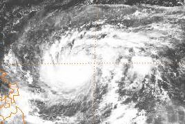
track=Dot 1985 track.pngOctober 13
dissipated=October 22
highest winds=150 knots (1-min)
lowest pressure=897 mbarOctober 11 . It headed west-northwestward, strengthening to a tropical storm on the 13th and a typhoon on the 14th. Dot rapidly intensified to a convert|175|mi/h|km/h|abbr=on Super Typhoon on the 16th, the only one of the year, and steadily weakened until hitting eastern Luzon as a convert|130|mi/h|km/h|abbr=on typhoon on the 18th. It crossed the South China Sea, hit southernHainan Island , and made its final landfall on northern Vietnam on the 21st as a convert|70|mi/h|km/h|abbr=on tropical storm. [Joint Typhoon Warning Center. [http://metocph.nmci.navy.mil/jtwc/atcr/1985atcr/pdf/wnp/21w.pdf Super Typhoon Dot.] Retrieved on2007-02-04 .] Dot caused 101 fatalities and 2.13 billion Philippine Pesos (1987 pesos) in damage. [Philippine Atmospheric Geophysics and Astronomical Services Administration. [http://www.pagasa.dost.gov.ph/cab/dtc_10.htm Most Destructive Tropical Cyclones for the Month of October (1948-2000).] Retrieved on2007-02-04 .]Tropical Storm Ellis
infobox hurricane small
name=Tropical Storm Ellis
category=storm
type=tropical storm
track=Ellis 1985 track.pngOctober 16
dissipated=October 20 ,1985
highest winds=60 mph [https://metocph.nmci.navy.mil/jtwc/atcr/1985atcr/pdf/1985.html 1985 ATCR TABLE OF CONTENTS ] ]
lowest pressure=995 mbar [https://metocph.nmci.navy.mil/jtwc/atcr/1985atcr/pdf/1985.html 1985 ATCR TABLE OF CONTENTS ] ]
total da
total fatalities=None
hurricane season=1985 Pacific typhoon seasonTyphoon Faye
infobox hurricane small
name=Typhoon Faye
category=cat3
type=TY
track=Faye 1985 track.pngOctober 23
dissipated=November 01 ,1985
highest winds=115 mph [https://metocph.nmci.navy.mil/jtwc/atcr/1985atcr/pdf/1985.html 1985 ATCR TABLE OF CONTENTS ] ]
lowest pressure=960 mbar [https://metocph.nmci.navy.mil/jtwc/atcr/1985atcr/pdf/1985.html 1985 ATCR TABLE OF CONTENTS ] ]
total da
total fatalities=None
hurricane season=1985 Pacific typhoon seasonTropical Storm Gordon
infobox hurricane small
name=Tropical Storm Gordon
category=storm
type=tropical storm
track=Gordon 1985 track.pngNovember 20
dissipated=November 26 ,1985
highest winds=50 mph [https://metocph.nmci.navy.mil/jtwc/atcr/1985atcr/pdf/1985.html 1985 ATCR TABLE OF CONTENTS ] ]
lowest pressure=997 mbar [https://metocph.nmci.navy.mil/jtwc/atcr/1985atcr/pdf/1985.html 1985 ATCR TABLE OF CONTENTS ] ]
total da
total fatalities=None
hurricane season=1985 Pacific typhoon seasonTyphoon Hope
infobox hurricane small
name=Typhoon Hope
category=cat3
type=typhoon
track=hope 1985 track.pngDecember 17
dissipated=December 24
highest winds=100 knots (1-min)
lowest pressure=944 mbarDecember 13 betweenTruk andPohnpei . The system moved westward, and slowly developed. By early onDecember 18 , a tropical depression had formed, and intensification continued for the next couple days as Hope became an intense typhoon on the afternoon ofDecember 20 . Weakening was seen later that day, and its eye disappeared. The system moved west-northwest, threateningLuzon for a time. Just before landfall, Hope recurved north and eastward, sparing thePhilippines , and becoming anextratropical cyclone onDecember 24 . [Joint Typhoon Warning Center. [http://metocph.nmci.navy.mil/jtwc/atcr/1985atcr/pdf/wnp/25w.pdf Typhoon Hope.] Retrieved on2007-02-04 .]Tropical Storm Irving
infobox hurricane small
name=Tropical Storm Irving
category=storm
type=tropical storm
track=irving 1985 track.pngDecember 18
dissipated=December 21
highest winds=60 knots (1-min)
lowest pressure=994 mbarSouth China Sea masked this system's existence. The cyclone was first noted just west of thePhilippines onDecember 18 and moved westward, becoming a tropical storm onDecember 19 . As it approached southernVietnam , the cyclone turned southwest and weakened, dissipating as it made landfall along theMalay peninsula . [Joint Typhoon Warning Center. [http://metocph.nmci.navy.mil/jtwc/atcr/1985atcr/pdf/wnp/26w.pdf Tropical Storm Irving.] Retrieved on2007-02-04 .]1985 storm names
Western North Pacific tropical cyclones were named by the
Joint Typhoon Warning Center . The first storm of 1985 was named Elsie and the final one was named Irving.One central Pacific system, Tropical Depression Two-C, crossed into this basin, keeping its "C" suffix but earning a West Pacific name.
ee also
*
1985 Pacific hurricane season
*1985 Atlantic hurricane season
*1985 North Indian cyclone seasonReferences
External links
* [http://www.typhoon2000.ph Typhoon2000 Philippine typhoon website] .
* [http://www.typhoon2000.ph/plotting/PhilippineTyphoonChart.gifPhilippine Area of Responsibility] .
* [https://metocph.nmci.navy.mil/jtwc.html Joint Typhoon Warning Center] .
* [http://www.weather.gov.hk/informtc/sound/tc_pronunciatione.htm Meaning of Tokyo Typhoon Centre names] .

Wikimedia Foundation. 2010.