- 1992 Pacific hurricane season
Infobox hurricane season
Basin=EPac
Year=1992
Track=1992 Pacific hurricane season map.pngJanuary 26 ,1992
Last storm dissipated=November 22 ,1992
Strongest storm name=Tina
Strongest storm winds=130
Strongest storm pressure=932
Average wind speed=1
Total depressions=30
Total storms=27
Total hurricanes=16
Total intense=10
Fatalities=17
Da
Inflated=1
five seasons=1990, 1991, 1992, 1993, 1994Hurricane Iniki , which caused billions of dollars of damage to theHawaiian Islands . Hurricanes Lester, Virgil, Winifred, and Orlene also made landfall and killed several people, but were significantly less destructive. Hurricane Darby and Tropical Storm Agatha brought rains and more destruction toMexico , without making landfall. Hurricane Tina was the longest-lasting pacific hurricane at the time. Also of note are Hurricane Ekeka and Tropical Storm Hali, which formed in late January and March, respectively.eason Summary
The season officially started on
May 15 ,1992 in the eastern Pacific, and onJune 1 ,1992 in the central Pacific, and lasted untilNovember 30 ,1992 . These dates conventionally delimit the period of each year when most tropical cyclones form in the northeasternPacific Ocean . The season wildly exceeded these bounds, however, as climatological effects including anEl Niño caused Hurricane Ekeka to form onJanuary 26 .This season, there were twenty-four named storms in the eastern Pacific. Of these, fourteen became hurricanes and eight became major hurricanes by reaching Category 3 or higher on the
Saffir-Simpson Hurricane Scale . In the central Pacific, three named storms formed, of which two were major hurricanes. Several storms moved in from the east. The eleven total tropical cyclones entering or forming in the central Pacific is a record level. Despite this activity, there were only five landfalls.Additionally there were three named storms in the central Pacific (west of longitude 140° West). Two of these became hurricanes.
torms
Hurricane Ekeka
Infobox Hurricane Small
Basin=EPac.jpg)
Track=Ekeka 1992 track.pngJanuary 28
Dissipated=February 4
1-min winds=100January 28 . It became a Category 3 before wind shear weakened the cyclone and eventually dissipated the low as it neared the Marshall IslandsFebruary 2 .Tropical Storm Hali
Infobox Hurricane Small
Basin=EPac.jpg)
Track=Hali 1992 track.pngMarch 28
Dissipated=March 30
1-min winds=45March 28 , a low-latitude area ofthunderstorm s organized into Tropical Depression Two-C. The next day, it intensified into a tropical storm and was named Hali, which is Hawaiian for Holly.cite web| author=Central Pacific Hurricane Center| year=1992| title=Hurricane Hali Preliminary Report| publisher=Central Pacific Hurricane Center| accessdate=2007-08-18| url=http://www.prh.noaa.gov/cphc/summaries/1992.php#Hali] The reached its peak intensity onMarch 29 . Almost immediately thereafter, wind shear blew the top off the system and caused it to fall apart. TheCentral Pacific Hurricane Center declared the system dissipated onMarch 30 .Tropical Storm Hali had no impact on land. However, it is also a meteorological enigma. Hali is the only known eastern Pacific tropical cyclone to develop in the month of March. It is thus the strongest March storm. cite web| author=Dan Voight| year=2007| title=Unisys 1992 EPHS Archive| publisher=Unisys Inc.| accessdate=2006-03-16| url=http://www.weather.unisys.com/hurricane/e_pacific/1992/index.html]
Tropical Storm Agatha
Infobox Hurricane Small
Basin=EPac.jpg)
Track=Agatha 1992 track.pngJune 1
Dissipated=June 5
1-min winds=60
Pressure=990June 1 . It moved north for the next two days. The depression strengthened into a tropical storm onJune 2 . After peaking the same day, Agatha slowed down and started drifting west. It steadily weakened, falling to a depression onJune 5 . Agatha had dissipated by the next day.cite web| author=Miles B. Lawrence| year=1992-06-28 | title=Tropical Storm Agatha Preliminary Report| publisher=National Hurricane Center| accessdate=2007-08-18| url=http://www.nhc.noaa.gov/archive/storm_wallets/epacific/ep1992-prelim/agatha/prelim01.gif] Agatha approached close enough to the coast of Mexico that watches and warnings were issued. Gale-force winds were not reported, and there was no deaths and no damage. The only other impact was isolated instances of flash-flooding due to rain.Tropical Depression Two-E
Infobox Hurricane Small
Basin=EPac
Formed=June 16
Dissipated=June 19
1-min winds=30A tropical depression formed near 114W onJune 16 . The storm moved west for a short time, reaching a peak intensity 1009 mbar and maximum sustained winds of convert|35|mi/h|km/h|abbr=on. It dissipated onJune 19 .cite web| url=http://ams.allenpress.com/archive/1520-0493/122/3/pdf/i1520-0493-122-3-549.pdf| title=Eastern North Pacific Hurricane Season of 1992|accessdate=2007-03-03| author=Miles B. Lawrence| coauthors=Edward N. Rappaport| year=1994| month=March| work=Monthly Weather Review| publisher=American Meteorological Society]Tropical Storm Blas
Infobox Hurricane Small
Basin=EPac.jpg)
Track=Blas 1992 track.pngJune 22
Dissipated=June 23
1-min winds=35
Pressure=1004Dakar, Africa onJune 4 and crossed theCape Verde Islands by the day after. The wave continued westward and onJune 10 , passed theWindward Islands . The wave went throughCentral America during the period ofJune 14 andJune 16 . The system entered the Eastern Pacific basin without gaining much convection. Over waters marginally suitable for cyclogenesis, a tropical wave organized into the second depression of the season onJune 22 . It briefly reached tropical storm strength onJune 23 . It then moved over cooler waters and dissipated the next day. Blas did not have any impact on land masses.cite web| author=Lixion A. Avila| year=1992-08-08 | title=Tropical Storm Agatha Preliminary Report| publisher=National Hurricane Center| accessdate=2007-08-18| url=http://www.nhc.noaa.gov/archive/storm_wallets/epacific/ep1992-prelim/blas/prelim01.gif]Hurricane Celia
Infobox Hurricane Small
Basin=EPac.jpg)
Track=Celia 1992 track.pngJune 22
Dissipated=July 4
1-min winds=125
Pressure=935June 8 off the coast of Africa.cite web| author=Richard J. Pasch| year=1992-12-02 | title=Hurricane Celia Preliminary Report - Page 1| publisher=National Hurricane Center| accessdate=2007-08-18| url=http://www.nhc.noaa.gov/archive/storm_wallets/epacific/ep1992-prelim/celia/prelim01.gif] The system moved toward Central America and crossed over into the East Pacific basin around the 19th. The NHC declared the wave as a tropical depression onJune 22 farther east than usual due to the low vertical wind shear. The NHC declared it as a tropical storm on the 23rd and was given the name Celia. Soon afterwards Celia started strengthening and soon became a hurricane. Celia started deepening rapidly starting aroundJune 26 and soon became a Category 4 major hurricane with winds of convert|125|kn|km/h and a minimal pressure of 935 mbar.cite web| author=Richard J. Pasch| year=1992-12-02 | title=Hurricane Celia Preliminary Report - Page 2| publisher=National Hurricane Center| accessdate=2007-08-18| url=http://www.nhc.noaa.gov/archive/storm_wallets/epacific/ep1992-prelim/celia/prelim02.gif] Celia maintained Category 4 intensity for about 24 hours and then start gradually weakening. Celia fell below hurricane status onJuly 2 and to tropical depression status the next day. Thereafter, all that was left of Celia was a swirl of low-convection clouds and was impossible to recognize onJuly 4 .Hurricane Darby
Infobox Hurricane Small
Basin=EPac.jpg)
Track=Darby 1992 track.pngJuly 2
Dissipated=July 10
1-min winds=105
Pressure=968July 2 . It strengthened and was named Darby the next day. Steering currents became very strong, and Darby accelerated as it paralleled the coast of Mexico. It strengthened into a hurricane onJuly 5 and also substantially increased in size. It peaked as a strong Category 3 onJuly 6 . Darby began to substantially weaken thereafter as it passed over cooler waters. The hurricane weakened into a storm and then a depression onJuly 8 andJuly 9 , respectively. Tropical Depression Darby lost tropical characteristics the next day. Moisture from the hurricane eventually spread over parts of the Continental United States.cite web| author=Britt Max Mayfield| year=1992-08-09 | title=Hurricane Darby Preliminary Report - Page 1| publisher=National Hurricane Center| accessdate=2007-08-18| url=http://www.nhc.noaa.gov/archive/storm_wallets/epacific/ep1992-prelim/darby/prelim01.gif]During Darby's formation, flooding from the cyclone's rainbands killed three people in
Acapulco ,Guerrero and 180 shops were damaged. Four fishermen were reported missing, fate unknown. Manzanillo,Colima , reported sustained winds just above tropical-storm force. The hurricane's remnants brought mainly light rain to the U.S. state ofCalifornia . Cloud cover als delayed the landing of the Space Shuttle "Columbia" for one day. South-facing beaches of that state were pounded with waves up to 7 feet (2.3 m) in height. A monetary value for damage is not available.cite web| author=Britt Max Mayfield| year=1992-08-09 | title=Hurricane Darby Preliminary Report - Page 2| publisher=National Hurricane Center| accessdate=2007-08-18| url=http://www.nhc.noaa.gov/archive/storm_wallets/epacific/ep1992-prelim/darby/prelim02.gif]Darby also caused a few shipping accidents. A pleasure craft, the "Oasis", had an engine failure and was abandoned. The seven people aboard were rescued, but the boat was sunk. A smaller sailboat, the "Hosanna", had difficulties but was towed to a safe location by a cutter from the
United States Coast Guard . A fishing boat at an unspecified location also experienced difficulties.cite web| author=Britt Max Mayfield| year=1992-08-09 | title=Hurricane Darby Preliminary Report - Page 3| publisher=National Hurricane Center| accessdate=2007-08-18| url=http://www.nhc.noaa.gov/archive/storm_wallets/epacific/ep1992-prelim/darby/prelim03.gif]Hurricane Estelle
Infobox Hurricane Small
Basin=EPac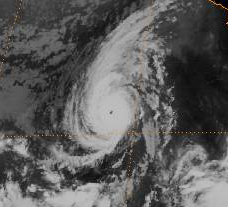
Track=Estelle 1992 track.pngJuly 9
Dissipated=July 17
1-min winds=120
Pressure=943National Hurricane Center indicates that it may have formed from a tropical wave that began onJune 23 off theAfrican coast.cite web| author=Edward Rappaport| year=1992-08-10 | title=Hurricane Estelle Preliminary Report| publisher=National Hurricane Center| accessdate=2007-08-18| url=http://www.nhc.noaa.gov/archive/storm_wallets/epacific/ep1992-prelim/estelle/prelim01.gif] The wave began to move at low latitudes and passed the northern part ofSouth America . OnJuly 2 , deep convection began to join with the wave as it crossed into the eastern Pacific Ocean onJuly 7 . Reports indicate that the wave strengthened into Tropical Depression Five onJuly 9 . 18 hours later, the depression strengthened into Tropical Storm Estelle in unusually strong wind shear. The shear began to weaken and an eye began to form in Estelle onJuly 11 . These eye formations caused the NHC to upgrade Estelle to a hurricane.From early
July 11 to lateJuly 15 , Estelle moved at about 7 - convert|15|mi/h|km/h|abbr=on to the northwest. During this period, Estelle reached convert|130|mi/h|km/h|abbr=on winds and became a Category 4 hurricane. Estelle to weaken gradually and onJuly 17 , Estelle had completely lost its characteristics. Estelle did not affect land in its lifetime, thus no damage was reported.Hurricane Frank
Infobox Hurricane Small
Basin=EPac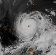
Track=Frank 1992 track.pngJuly 13
Dissipated=July 23
1-min winds=125
Pressure=935July 13 , dissipatedJuly 23 .Hurricane Georgette
Infobox Hurricane Small
Basin=EPac
Track=Georgette 1992 track.pngJuly 14
Dissipated=July 26
1-min winds=95
Pressure=964July 14 , dissipatedJuly 26 .Tropical Storm Howard
Infobox Hurricane Small
Basin=EPac
Track=Howard 1992 track.pngJuly 26
Dissipated=July 30
1-min winds=55
Pressure=992July 26 , dissipatedJuly 30 .Tropical Storm Isis
Infobox Hurricane Small
Basin=EPac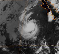
Track=Isis 1992 track.pngJuly 28
Dissipated=August 2
1-min winds=55
Pressure=992July 28 , dissipatedAugust 2 .Hurricane Javier
Infobox Hurricane Small
Basin=EPac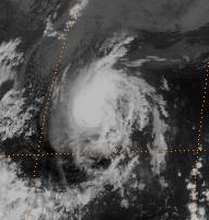
Track=Javier 1992 track.pngJuly 30
Dissipated=August 12
1-min winds=70
Pressure=985July 30 , dissipatedAugust 12 .Tropical Depression Twelve-E
Infobox Hurricane Small
Basin=EPac
Formed=August 10
Dissipated=August 12
1-min winds=30
Pressure=1008Minimum pressure of 1008 mb. FormedAugust 10 , dissipatedAugust 12 . [http://www.nhc.noaa.gov/archive/storm_wallets/epacific/ep1992/td12e/ Tropical Depression Twelve-E Archive] ]Tropical Storm Kay
Infobox Hurricane Small
Basin=EPac.jpg)
Track=Kay 1992 track.pngAugust 18
Dissipated=August 22
1-min winds=45
Pressure=1000August 18 , dissipatedAugust 22 .Hurricane Lester
Infobox Hurricane Small
Basin=EPac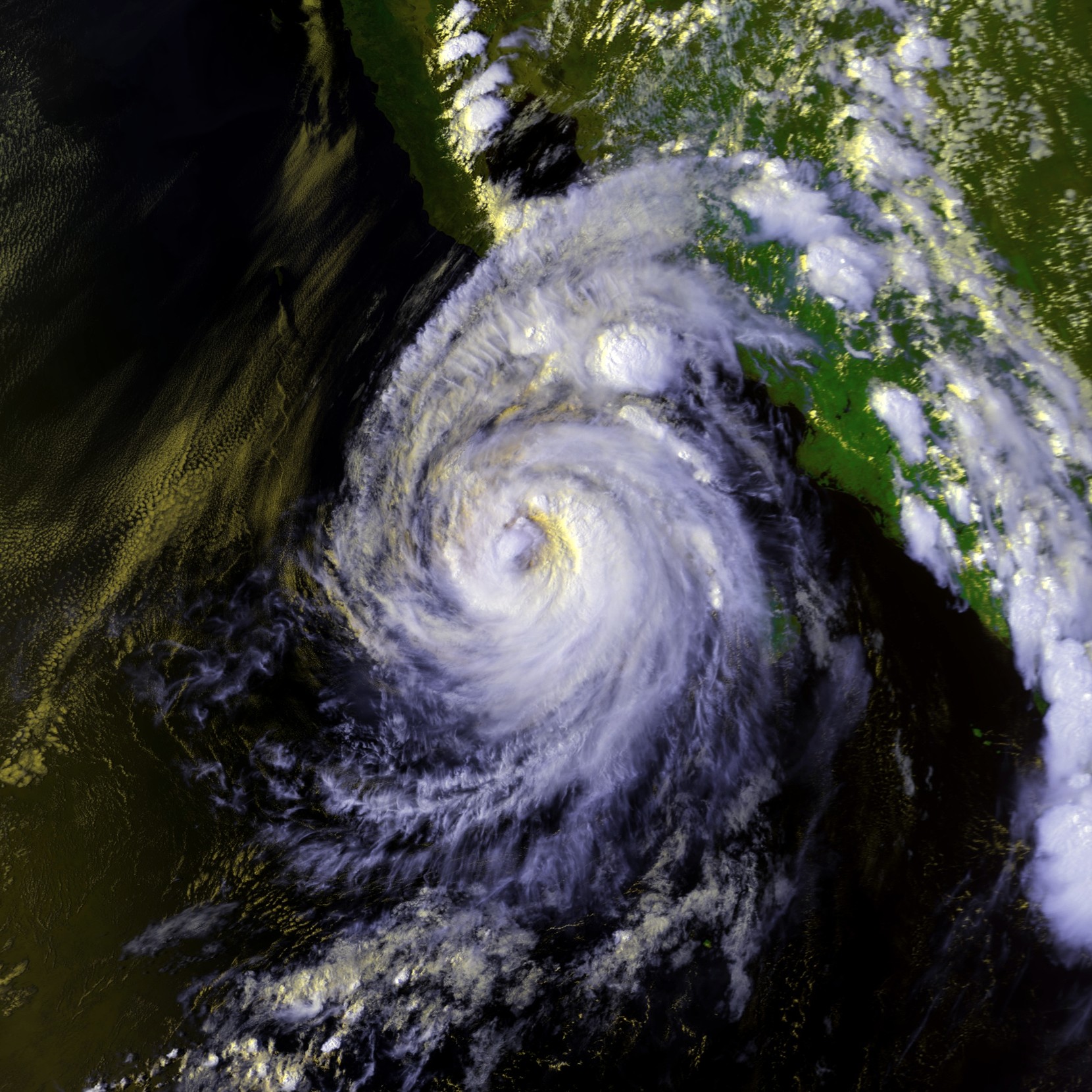
Track=Lester 1992 track.pngAugust 20
Dissipated=August 24
1-min winds=70
Pressure=985Baja California Peninsula on the 23rd, striking mainland Mexico late that day. Accelerating northeast, Lester entered the U.S. state ofArizona as a tropical storm andNew Mexico as a tropical depression before ejecting out into the Plains. [http://www.hpc.ncep.noaa.gov/tropical/rain/lester1992.html HPC Lester Rainfall] accessed March 6, 2006]No deaths were reported. Lester left over 5000 people homeless. Several tiny settlements west of
Hermosillo ,Sonora , and on a highway toSan Diego, California , were destroyed. A ship called the "Gladiator" rolled over 33 degrees to both starboard and port, spilling a considerable amount of cargo.Tropical Storm Madeline
Infobox Hurricane Small
Basin=EPac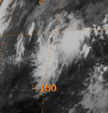
Track=Madeline 1992 track.pngAugust 27
Dissipated=August 31
1-min winds=45
Pressure=999tropical wave organized into Tropical Depression 14-E onAugust 27 . Banding and convection increased, and the depression became a tropical storm the next day. Development continued, and Madeline peaked with a minimum pressure of 999 mb, and winds of convert|45|kn|km/h, onAugust 29 . As the system progressed westward, it entered a region of strongwind shear and had dissipated onAugust 31 . The system never came near land.cite web| author=Lixion Avila| year=1992| title=Tropical Storm Madeline Preliminary Report| publisher=National Hurricane Center| accessdate=2007-08-18| url=http://www.nhc.noaa.gov/archive/storm_wallets/epacific/ep1992-prelim/madeline/prelim01.gif]Tropical Storm Newton
Infobox Hurricane Small
Basin=EPac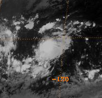
Track=Newton 1992 track.pngAugust 27
Dissipated=August 31
1-min winds=45
Pressure=999August 27 , dissipatedAugust 31 .Hurricane Orlene
Infobox Hurricane Small
Basin=EPac
Track=Orlene 1992 track.pngSeptember 2
Dissipated=September 14
1-min winds=125
Pressure=934September 2 , dissipatedSeptember 14 . As a depression, Orlene made landfall on theBig Island of Hawaii . It caused downpours and washed out roads.Hurricane Iniki
Infobox Hurricane Small
Basin=EPac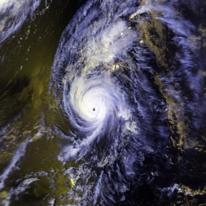
Track=Iniki 1992 track.pngSeptember 5
Dissipated=September 13
1-min winds=125
Pressure=938September 5 , atropical wave organized into Tropical Depression Eighteen-E. After crossing 140°W, the system strengthened into a tropical storm onSeptember 8 and was named Iniki (Hawaiian for Enid [http://www.prh.noaa.gov/cphc/summaries/1992.php#Iniki CPHC Iniki Report] accessed March 6, 2006] ) In a favorable environment, Iniki intensified into a hurricane onSeptember 9 and a major hurricane the day after. Iniki reached Category 4 intensity early onSeptember 11 .Meanwhile, a series of troughs broke down a ridge over the
Hawaiian Islands . This recurved Iniki and accelerated the system northward. Iniki's eye passed directly overKauai onSeptember 11 , the first hurricane to make landfall in Hawaii since Hurricane Dot in 1959. Iniki weakened to a tropical storm and went extratropical onSeptember 13 and was promptly absorbed by a front.At the time, Hurricane Iniki was the costliest Pacific hurricane in recorded history. Damage was heavy on Kauai, with many buildings being unroofed. A total of 1241 houses were completely destroyed. The total cost of damage was 2 billion dollars. Six people died and more than 100 people were injured.
Hurricane Paine
Infobox Hurricane Small
Basin=EPac
Track=Paine 1992 track.pngSeptember 11
Dissipated=September 16
1-min winds=65
Pressure=987September 11 , dissipatedSeptember 16 .Hurricane Roslyn
Infobox Hurricane Small
Basin=EPac.jpg)
Track=Roslyn 1992 track.pngSeptember 13
Dissipated=September 25
1-min winds=85
Pressure=975September 13 , dissipatedSeptember 25 .Hurricane Seymour
Infobox Hurricane Small
Basin=EPac
Track=Seymour 1992 track.pngSeptember 17
Dissipated=September 27
1-min winds=75
Pressure=980September 17 , dissipatedSeptember 27 .Hurricane Tina
Infobox Hurricane Small
Basin=EPac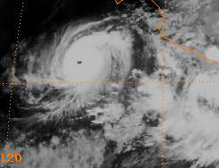
Track=Tina 1992 track.pngSeptember 17
Dissipated=October 11
1-min winds=130
Pressure=932September 17 . It moved glacially towards the west and strengthened into a hurricane. A breakdown in a ridge and to the north and a trough then recurved Tina to the northeast and towards land, still moving slowly and gradually slowing down.The trough broke down and was replaced by a strong ridge. Tina then changed direction again and headed out to sea. It intensified into a Category 4 storm with a central pressure of 932 millibars. Tina then slowly weakened as it turned to the north. The stubborn Tropical Depression Tina dissipated on
11 October , shortly after entering the central Pacific.Due to its erratic track and slow motion, Tina was alive from
September 17 toOctober 11 — a span of 24 days. This is the record for the easternPacific Ocean , smashing the east/central record of 20 days held byHurricane Fico in the 1978 season and surpassing Typhoon Rita's west Pacific 1972 record. It was itself surpassed just two years later by Hurricane John.Hurricane Virgil
Infobox Hurricane Small
Basin=EPac.jpg)
Track=Virgil 1992 track.pngOctober 1
Dissipated=October 5
1-min winds=117
Pressure=948Because Virgil made landfall in a sparsely populated area, damage from storm surge was minimal. The chief effect was heavy rain and flooding, peaking at over convert|10|in|cm in one location. One person was reported missing in the state of
Colima , and three people were injured inGuerrero . More than 1000 homes were damaged in Guerrero,Michoacán , and Colima, as was convert|7400|acre|km2 of farmland. A flood on theAtoyac River washed away 500 homes in Guerrero, which prompted the evacuation of 2500 people. A passenger train north ofLázaro Cárdenas, Michoacán , was derailed when it encountered washed-out roadbeds.Hurricane Winifred
Infobox Hurricane Small
Basin=EPac.jpg)
Track=Winifred 1992 track.pngOctober 6
Dissipated=October 10
1-min winds=100
Pressure=960October 10 .Three people were killed by floods. Damage was concentrated in
Colima andMichoacán . Electricity and water systems was knocked out in Colima. There was also damage to hotels, restaurants, and houses. Total damage in Colima was estimated at 16 million pesos (5 million USD) by that state's governor. Flooding along the coastal highway connectingLázaro Cárdenas, Michoacán , withIxtapa -Zihuatanejo inGuerrero was extensive. Roughly 840 square kilometres (320 mi²) of farmland was damaged.Tropical Storm Xavier
Infobox Hurricane Small
Basin=EPac
Track=Xavier 1992 track.pngOctober 13
Dissipated=October 15
1-min winds=40
Pressure=1003October 13 , dissipatedOctober 15 .Tropical Storm Yolanda
Infobox Hurricane Small
Basin=EPac.jpg)
Track=Yolanda 1992 track.pngOctober 15
Dissipated=October 22
1-min winds=55
Pressure=993October 15 , dissipatedOctober 22 .Tropical Storm Zeke
Infobox Hurricane Small
Basin=EPac.jpg)
Track=Zeke 1992 track.pngOctober 25
Dissipated=October 30
1-min winds=45
Pressure=1000October 25 , dissipatedOctober 30 .Tropical Depression Three-C
Infobox Hurricane Small
Basin=EPac
Formed=November 21
Dissipated=November 21
1-min winds=30This storm formedNovember 21 , dissipatedNovember 21 . [http://www.prh.noaa.gov/cphc/summaries/1992.php#Three-c Tropical Depression Three-C Archive] ]Accumulated Cyclone Energy Rating (ACE)
The table below shows the ACE for each storm in the season. ACE is, broadly speaking, a measure of the power of the hurricane multiplied by the length of time it existed, so storms that last a long time, as well as particularly strong hurricanes, have high ACEs. ACE is only calculated for full advisories on tropical systems at or exceeding 34 knots (39 mph, 63 km/h) or tropical storm strength. The figures in parenthesis are for storms in the Central Pacific basin west of 140°W; those not in parenthesis are for the Eastern Pacific basin. This season had the highest ACE of any season on record, with an overall value of 295.492. The 1990 season also had a high ACE, at about 250 that year, but only about 4 of that was fron the central Pacific. 33.34 of this seasons total ace came from the central Pacific; excluding it, the overall ace was 262.152. The 1990 season had 6 less storms than this year, but because 16 of the 21 storms that year became hurricanes (the record for any season), and the fact that the major hurricanes in 1990, like Hernan and Trudy, were stronger than this year's ones, the 1990 season's ACE was only 12 lower than this season, so this season had a higher ACE than 1990, but the average ACE per storm that year was higher than this year.
The cumulative ACE for the Eastern Pacific this season fell within the official "Near Normal" grading, even though the number of tropical storms, hurricanes, and major hurricanes was well above the long term average.
torm names
The following names were used for named storms that formed in the northeast Pacific in 1992. No eastern Pacific names were retired, so it was used again in the 1998 season. This is the same list used for the 1986 season. Storms were named Seymour, Tina, Virgil, Winifred, Xavier, Yolanda, and Zeke for the first time in 1992. Yolanda and Zeke were the first time that Y and Z names had been used to name storms.
All names on the list were used this year. This is the second time that a northeast Pacific hurricane season had exhausted its list. The 1983 season also used every name on its list, but the list only went to the W name at the time. The 1985 season's list was lengthened while it was going on to prevent exhaustion.
Three names from the central Pacific list were used - Ekeka, Hali, and Iniki. This was the first usage for all of these names.
Retirement
One name was retired from the Central Pacific list after the 1992 season: Iniki. It was replaced with Iolana. Later, in 2006, a name change for various Central Pacific names took place and a second name was removed: Hali. It was replaced by Hene. [cite web|author=Dennis H. McCarthy|year=2007|title=National Weather Service Instruction Tropical Cyclone Names and Pronunciation Guide|accessdate=2007-02-12|url=http://www.weather.gov/directives/sym/pd01006006curr.pdf|format=PDF]
ee also
*
List of Pacific hurricanes
*List of Pacific hurricane seasons
*1992 Atlantic hurricane season
*1992 Pacific typhoon season
*1992 North Indian Ocean cyclone season
*Southern Hemisphere tropical cyclone seasons: 1991–92, 1992–93References
External links
* [ftp://ftp.nhc.noaa.gov/pub/storm_archives/pacific/prelimep/ep1992/ NHC 1992 Pacific hurricane season archive]
* [http://www.prh.noaa.gov/cphc/pages/hurrclimate.php#1992 Central Pacific Hurricane Center archive]

Wikimedia Foundation. 2010.