- Doxford Park
-
Coordinates: 54°51′42″N 1°25′22″W / 54.8618°N 1.4227°W
Doxford Park 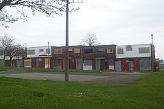
Boarded up, flat-roofed houses in Doxford Park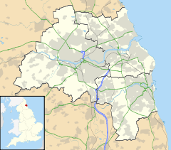
 Doxford Park
Doxford Park shown within Tyne and WearPopulation 8,700 OS grid reference NZ375525 Metropolitan borough City of Sunderland Metropolitan county Tyne and Wear Region North East Country England Sovereign state United Kingdom Post town SUNDERLAND Postcode district SR2, SR3 Dialling code 0191 Police Northumbria Fire Tyne and Wear Ambulance North East EU Parliament North East England UK Parliament Sunderland South List of places: UK • England • Tyne and Wear Doxford Park (known locally as Doxy Park) is a suburb of Sunderland, Tyne and Wear, located to the south-west of the city centre.
Doxford Park is also the name of a wooded area of land located within the suburb.
Doxford Park has been built up in stages from the mid 1960s onwards, original proposals calling the area "Silksworth Township". It is surrounded by the A19 to the west, farmland to the south, Silksworth to the North, and Tunstall to the east. It is bisected by the B1286 Doxford Park Way dual carriageway.
Many of the houses in Doxford Park were becoming unsafe and uneconomic to repair so Gentoo (formerly the Sunderland Housing Group) is undertaking a massive programme of renewal to redevelop the estate, which will be called 'Beckwith Grange', and has completed Phases 1 & 2 of the project (with 4 phases left to complete).
At the centre of the suburb lies a shopping centre built in the late 1970s and initially named the President Carter Shopping Centre, after it was opened by U.S. President Jimmy Carter during an official visit to the region in 1977. Following redevelopment in mid 1990s the centre is now a large Morrisons supermarket.
Doxford Park is home to one school Mill Hill Primary School and an adjoining nursery [Mill Hill Nursery]. The Portland School for children with special needs was opened in the nearby Chapelgarth area in December 2001 by Prime Minister Tony Blair. For secondary education, most children from the area go to Farringdon Community Sports College in the nearby estate of Farringdon.
The Doxford International Business Park is located less than a mile away from the estate.
See also
External links
Categories:- City of Sunderland suburbs
- Tyne and Wear geography stubs


Wikimedia Foundation. 2010.