Mynydd Mawr

Mynydd Mawr
Mynydd Mawr

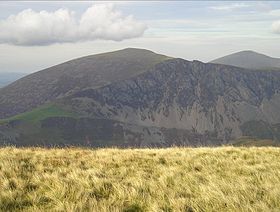
Mynydd Mawr from Trum y Ddysgl
Elevation 698 m (2,290 ft)
Prominence 462 m (1,516 ft)
Parent peak Moel Hebog
Listing Marilyn, Hewitt, Nuttall
Translation big mountain (Welsh)
Pronunciation Welsh: [ˈmənɨð ˈmaur]
Location
Location Gwynedd,  Wales
Range Snowdonia
Topo map OS Landranger 115
OS grid SH539546

Mynydd Mawr (Welsh for big mountain) is a mountain in Snowdonia, North Wales, situated approximately 7 km (4.3 mi) west of Snowdon itself, overlooking Llyn Cwellyn and being the northern outlier of the Moel Hebog group. A popular ascent starts from Rhyd Ddu. On its western flank are the remains of ancient settlements and field systems. The profile of Mynydd Mawr from the north is often thought to resemble an elephant lying down, and consequently the mountain is often colloquially also called "Elephant Mountain".[1]

References

  1. ^ Nuttall, John & Anne (1999). The Mountains of England & Wales - Volume 1: Wales (2nd edition ed.). Milnthorpe, Cumbria: Cicerone. ISBN 1-85284-304-7.

External links

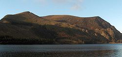
Mynydd Mawr and Llyn Cwellyn from the east

Coordinates: 53°04′07″N 4°10′55″W / 53.06860°N 4.18200°W / 53.06860; -4.18200


Wikimedia Foundation. 2010.

Игры ⚽ Поможем решить контрольную работу

Look at other dictionaries:

  • Llanelly and Mynydd Mawr Railway — This article describes the historical railway. For the current heritage railway see Llanelli and Mynydd Mawr Railway The Llanelly and Mynydd Mawr Railway (LMMR) was established in 1802 in Carmarthenshire, Wales, as the Carmarthenshire Tramroad by …   Wikipedia

  • Llanelli and Mynydd Mawr Railway — This article describes the current heritage railway. For the historical railway see Llanelly and Mynydd Mawr Railway. The Llanelli and Mynydd Mawr Railwaypronunciation needed is a heritage railway which aims to re instate as much as possible of… …   Wikipedia

  • Llanelly and Mynydd Mawr Railway — Strecke in Llanelli auf einem Diagramm des Railway Clearing House Die Llanelly and Mynydd Mawr Railway (LMMR) war eine britische Eisenbahngesellschaft in Carmarthenshire in Wales Inhaltsverzeichnis …   Deutsch Wikipedia

  • Mynydd Graig Goch — Crags on the summit of Mynydd Graig Goch Elevation …   Wikipedia

  • Mynydd Llysiau — from near Waun Fach. Behind are: Sugar Loaf (left) Pen Allt mawr (right) Elevation …   Wikipedia

  • Mawr — Ward Ordnance Survey OS grid reference: Maps for SN630030 Geography Principal locality …   Wikipedia

  • Mynydd Illtud — is an extensive area of common land three miles south east of Brecon in the Brecon Beacons National Park in the county of Powys, Wales. The common is an undulating plateau lying between 330 and 370 metres (1,080 and 1,210 ft) above sea level. Its …   Wikipedia

  • Crug Mawr — viewed from the Sugar Loaf Elevation …   Wikipedia

  • Aberdaron — Coordinates: 52°48′29″N 4°42′36″W / 52.808°N 4.710°W / 52.808; 4.710 …   Wikipedia

  • Aberdaron — Localidad de Gales …   Wikipedia Español

Share the article and excerpts

Direct link
Do a right-click on the link above
and select “Copy Link”