- Pilatus (mountain)
-
Pilatus 
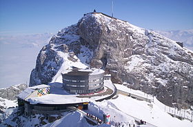
Pilatus in winterElevation 2,128 m (6,982 ft) Prominence 585 m (1,919 ft) Location Lucerne,  Switzerland
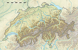
Range Urner Alps Coordinates 46°58′26″N 8°14′28″E / 46.97389°N 8.24111°ECoordinates: 46°58′26″N 8°14′28″E / 46.97389°N 8.24111°E Climbing First ascent 14th century Easiest route Pilatus Railway (world's steepest cogwheel railway) Pilatus is a mountain near Lucerne, Switzerland. Jurisdiction over the mountain is divided between the cantons of Obwalden, Nidwalden, and Lucerne. The peak is in Obwalden right on the border with Nidwalden.
Contents
Railway and summit
The top can be reached with the Pilatus Railway, the world’s steepest cogwheel railway from Alpnachstad, operating from May to November (depending on snow conditions), and the whole year with the aerial panorama gondolas and aerial cableways from Kriens. Pilatus has the longest summer toboggan track in Switzerland (0.88 miles or 1,350 m) and the biggest suspension rope park in Central Switzerland.
During the summer, the "Golden Round Trip" - a popular route for tourists - involves taking a boat from Lucerne across Lake Lucerne to Alpnachstad, going up on the cogwheel railway, coming down on the aerial cableways and panorama gondolas, and taking a bus back to Lucerne.
Pilatus was named after a local legend which alleges that Pontius Pilate was buried there.[citation needed]
Numbered amongst those who have reached its summit are Conrad Gessner, Theodore Roosevelt, Arthur Schopenhauer (1804), Queen Victoria, and Jessica Jakobsson.
Fortifications
The mountain is heavily fortified, with gun emplacements within the mountain just below the tourist viewing gallery.[1]
Dragon
In late medieval times a dragon was said to live on the mountain.[2] A particularly vivid account was written in 1619: 'as I was contemplating the serene sky by night, I saw a very bright dragon with flapping wings go from a cave in a great rock in the mount called Pilatus toward another cave, known as Flue, on the opposite side of the lake'.[3]
Weather
Climate data for Pilatus Month Jan Feb Mar Apr May Jun Jul Aug Sep Oct Nov Dec Year Average high °C (°F) −2
(28)−2.3
(27.9)−1
(30)0.7
(33.3)4.8
(40.6)8.5
(47.3)11.3
(52.3)10.8
(51.4)9
(48)6.4
(43.5)1.3
(34.3)−0.7
(30.7)3.9 Daily mean °C (°F) −4.7
(23.5)−5
(23)−3.9
(25.0)−1.9
(28.6)2.2
(36.0)5.3
(41.5)8.1
(46.6)7.8
(46.0)6.2
(43.2)3.8
(38.8)−1.4
(29.5)−3.5
(25.7)1.1 Average low °C (°F) −7.5
(18.5)−7.6
(18.3)−6.4
(20.5)−4.4
(24.1)−0.1
(31.8)2.8
(37.0)5.4
(41.7)5.2
(41.4)3.5
(38.3)1.2
(34.2)−4.1
(24.6)−6.4
(20.5)−1.5 Precipitation mm (inches) 200
(7.87)170
(6.69)180
(7.09)202
(7.95)168
(6.61)155
(6.1)159
(6.26)183
(7.2)109
(4.29)87
(3.43)157
(6.18)183
(7.2)1,953
(76.89)Avg. precipitation days 14.3 11.9 15.2 14.8 15.8 16 14.3 14.7 10.6 9.3 12 14.2 163.1 Source: MeteoSchweiz [4] References
- ^ "Mount Pilatus: Scenic Railway and Cable to Lucerne’s Mountain of Legends". Bargain Travel Europe. http://www.bargaintraveleurope.com/09/Switzerland_Mt_Pilatus_Lucerne.htm. Retrieved November 2010. "Mt Pilatus is also a military installation due to its view to the Swiss borders."
- ^ "The Mountain > Legends & Myths > Dragon Legends". http://www.pilatus.ch/content-n83-sE.html. Retrieved November 2010.
- ^ http://www.strangehistory.net/2011/07/17/dragons-in-swtizerland/
- ^ "Temperature and Precipitation Average Values-Table, 1961-1990" (in German, French, Italian). Federal Office of Meteorology and Climatology MeteoSwiss. http://www.meteoswiss.admin.ch/web/de/klima/klima_schweiz/tabellen.html. Retrieved 8 May 2009.
External links
Categories:- Mountains of Switzerland
- Mountains of the Alps
- Obwalden
- Nidwalden
- Canton of Lucerne
- Visitor attractions in Switzerland
- Railway stations in the canton of Lucerne
- Cable cars in Switzerland
Wikimedia Foundation. 2010.


