- Kibera
-
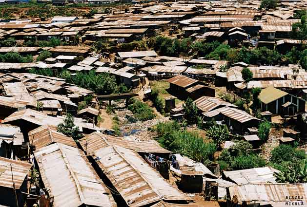
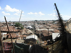 View of Kibera
Kibera (Nubian: Forest or Jungle[1]) is a division of Nairobi Area, Kenya, and neighbourhood of the city of Nairobi, located 5 kilometres (3.1 mi) from the city centre.[2] Kibera is the largest slum in Nairobi, and the second largest urban slum in Africa.[2][3][4] The 2009 Kenya Population and Housing Census reports Kibera's population as 170,070, contrary to previous estimates of one or two million people.[5]
The neighbourhood is divided into a number of villages, including Kianda, Soweto East, Gatwekera, Kisumu Ndogo, Lindi, Laini Saba, Siranga, Makina and Mashimoni. Conditions in Kibera are extremely poor, and most of its residents lack access to basic services, including electricity and running water.
Contents
History
Kibera originated as a settlement in the forests outside Nairobi, when Nubian soldiers returning from service with the King's African Rifles (KAR) were allocated plots there in return for their efforts around 1904. Kibera was situated on the KAR military exercise grounds in close proximity to the KAR headquarters along Thika Road. [6]. The British colonial government of the time allowed the settlement to grow informally, primarily because of the Nubians' status as former servants of the British crown, which put the colonial regime in their debt. Furthermore the Nubians, being "Detribalized Natives", had no claim on land in "Native Reserves".[citation needed] Over time, other tribes moved into the area to rent land from the Nubian landlords.
After Kenya became independent in 1963, a number of forms of housing were made illegal by the government. The new ruling affected Kibera on the basis of land tenure, rendering it an unauthorized settlement. Despite this, people continued to live there, and by the early 1970s landlords were renting out their properties in Kibera to significantly greater numbers of tenants than were permitted by law. The tenants, who are highly impoverished, cannot afford to rent legal housing, finding the rates offered in Kibera to be comparatively affordable. The number of residents in Kibera has increased accordingly despite its unauthorized nature. By 1974, members of the Kikuyu tribe predominated the population of Kibera, and had gained control over administrative positions, which were kept through political patronage.[7]
However a shift in Kenyan demographics has taken place since then. The Luo and Luya tribes from the West of Kenya being the primary areas of internal emigration. By the year 1995, Kibera had become a predominantly Luo slum and Mathare Valley nearby the predominantly Kikuyu slum area.[citation needed] The coincident rise of multi party politics in Kenya has caused the Luo leader and MP for much of Kibera, the parliamentary seat of Langata, Raila Odinga to be known for his ability to bring out a formidable demonstration force instantly. Meanwhile Mathare Valley has become a hotbed of gang warfare. Political tensions in the nation between the ethnic tribes escalated after the re-election of President Kibaki in 2007.
The Nubian community has a Council of Elders who are also the Trustees of its Trust. This Trust now claims all of Kibera. It claims that the extent of their land is over 1,100 acres (4.5 km2). It claims that owing to State sanctioned allotments the land area is now reduced to 780 acres (3.2 km2). The Government does not accept their claims but its rehousing program envisions a land extent around 300 acres (1.2 km2) for the claimed Nubian settlement. Neither side has left any room for negotiation from this position.
Presently, Kibera's residents represent all the major Kenyan ethnic backgrounds, with some areas being specifically dominated by peoples of one ethno-linguistic group. Many new residents come from rural areas with chronic underdevelopment and overpopulation issues. The multi-ethnic nature of Kibera's populism combined with the tribalism that pervades Kenyan politics has led to Kibera hosting a number of small ethnic conflicts throughout its century-long history. The Kenyan government owns all the land upon which Kibera stands, though it continues to not officially acknowledge the settlement; no basic services, schools, clinics, running water or lavatories are publicly provided, and the services that do exist are privately owned.[8]
Geography, population and culture
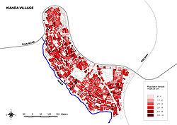 The population density in the Kianda village in western Kibera
Kibera is located in southwest Nairobi, roughly 5 kilometers from the city centre. Much of its southern border is bounded by the Nairobi river and the Nairobi Dam, an artificial lake that provides drinking water to the residents of the city.
Kibera is divided into 13 villages, including Kianda, Soweto, Gatwekera, Kisumu Ndogo, Lindi, Laini Saba, Siranga/Undugu, Makina and Mashimoni.
The 2009 Kenya Population and Housing Census reported Kibera's population as 170,070.[5] The Kibera slum was previously thought to be one of the biggest informal urban settlements in the world. Several actors had provided and published over the years growing estimations of the size of its population, most of them stating that it was the largest slum in Africa with the number of people there reaching over 1 million. According to Mike Davis, a well known expert on urban slums, Kibera had a population of about 800,000 people[9]. International Housing Coalition (IHC) talked about more than half a million people[10]. UN-Habitat had released several estimations ranging between 350,000 and 1 million people [11][12][13]. These statistics mainly come out of analysis of aerial pictures of the area. IRIN estimated a population density of 2000 residents per hectare[14]
In 2008 an independent team of researchers began a door-by-door survey named “Map Kibera Project”[15] with the aim to map physical and socio-demographic features of the slum. A trained team of locals, after having developed an ad-hoc surveying methodology, has so far gathered census data of over 15,000 people and completed the mapping of 5000 structures, services (public toilets, schools), and infrastructures (drainage system, water and electricity supply) in the village of Kianda. Looking upon Kianda's collected data, the population of the whole Kibera slum can be estimated between 235,000 and 270,000 people[16].
The Uganda Railway Line passes through the centre of the neighbourhood, providing passengers aboard the train a firsthand view of the slum. Kibera has a railway station, but most residents use buses and matatus to reach the city centre; carjacking, irresponsible driving, and poor traffic law enforcement are chronic issues.
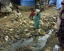
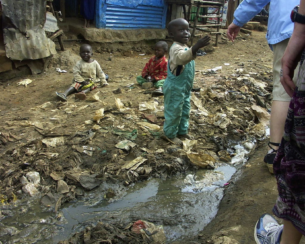
Kibera is heavily polluted by human refuse, garbage, soot, dust, and other wastes. The slum is contaminated with human and animal feces, due to the open sewage system and the frequent use of "flying toilets". The lack of sanitation combined with poor nutrition among residents accounts for many illnesses and diseases.
There is a community radio station, Pamoja FM.
Education
Most education centres in Kibera are classified as informal. Some start as babycare centres, which later develop into schools. Most are not regulated by the government. Some of the notable schools are Olympic Primary School, one of the leading government schools in the country, Kibera Primary School (also called Old Kibera), as well as several church-owned and privately owned schools. Notable Secondary schools include PCEA Silanga High School, owned by the Presbyterian Church of East Africa, Raila Educational centre, and Olympic secondary School among others. There is also a vocational training centre, PCEA Emmanuel Technical Training Centre, offering self-employment skills to the residents.
Slum upgrading
 The ground in much of Kibera is composed of refuse and rubbish
Kibera is one of the most studied slums in Africa, not only because it sits in the centre of the modern city, but also because UN-HABITAT, the United Nations' agency for human settlements, is headquartered close by. Ban Ki-moon visited the settlement within a month of his selection as UN secretary-general.[8]
Kibera, as one of the most pronounced slums within Kenya, is undergoing an intensive slum upgrading process. The government, UN-HABITAT and a contingent of NGOs, notably Maji na Ufanisi, are making inroads into the settlements in an attempt to facelift the housing and sanitary conditions.
There are three significant complicating factors to construction or upgrade within Kibera. The first is the rate of petty and serious crime. Building materials cannot be left unattended for long at any time because there is a very high chance of them being stolen. It is not uncommon for owners of storm-damaged dwellings to have to camp on top of the remnants of their homes until repairs can be made, to protect the raw materials from would-be thieves.
The second is the lack of building foundations. The ground in much of Kibera is literally composed of refuse and rubbish. Dwellings are often constructed atop this unstable ground, and therefore many structures collapse whenever the slum experiences flooding, which it does regularly. This means that even well-constructed buildings are often damaged by the collapse of nearby poorly constructed ones.
The third complicating factor is the unyielding topography and cramped sprawl of the area. Few houses have vehicle access, and many are at the bottoms of steep inclines (which heightens the flooding risk). This means that any construction efforts are made more difficult and costly by the fact that all materials must be brought in by hand.
Clearance
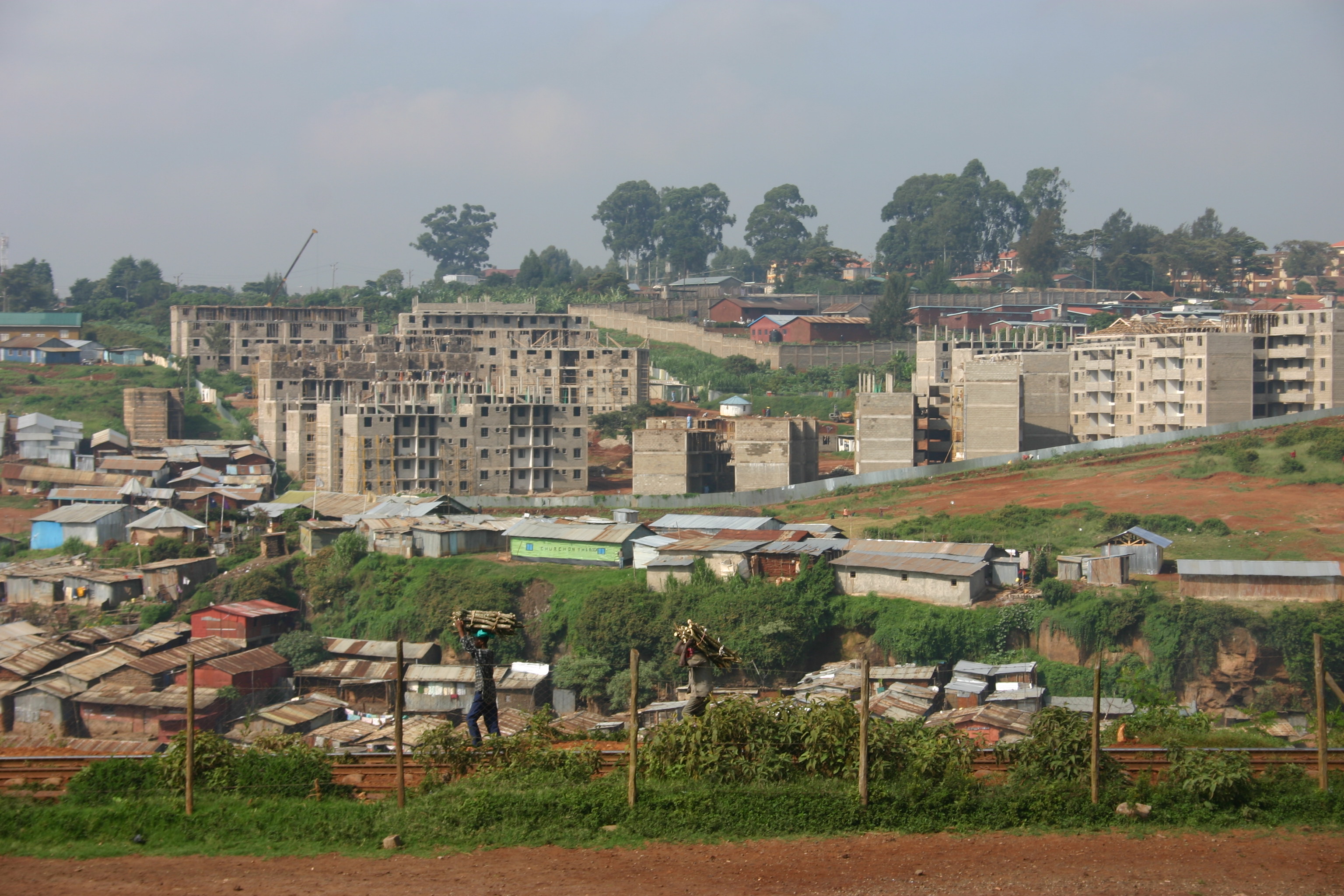
 The new apartments being built adjacent to Kibera
On 16 September 2009 the Kenyan government, which claims ownership of the land on which Kibera stands, began a long-term movement scheme which will rehouse the people who live in slums in Nairobi.[17]
The clearance of Kibera is expected to take between two and five years to complete. The entire project is planned to take nine years and will rehouse all the slum residents in the city.[18] The project has the backing of the United Nations and Prime Minister Raila Odinga, who is a local MP, and is expected to cost $1.2 billion.[17][18] The new communities are planned to include schools, markets, playgrounds and other facilities.[17] The first batch of around 1,500 people to leave the slum were taken away by truck on 16 September 2009 from 6:30 am local time and were rehoused in 300 newly constructed apartments with a monthly rent of around $10.[17][18]
The project start was postponed several times when Prime Minister Odinga was unavailable to oversee the first day.[19] He was joined on the first day by Housing Minister Soita Shitanda and his assistant Margaret Wanjiru, with all three helping residents to load their belongings onto the trucks.[19] Also present were several dozen armed police officers to oversee the arrangements and to deter any resistance.[19]
The process has been legally challenged by more than 80 people, and the Kenyan High Court has stated that the government cannot begin demolition works until the case is heard in October but will be able to demolish the homes of people who leave voluntarily before then.[17][18] The 80 plaintiffs are a mixture of middle-class landlords and Kibera residents, and they claim that the land in Kibera is theirs and hence the government has no right to demolish the shacks. The Nubian community, who have lived on the land for nearly 100 years, are also disappointed with the scheme, and one elder has said that the present housing should be improved instead.[17]
The project has also come under fire from urban planners who say that it risks repeating the mistakes of previous schemes, when poor families either shared two-room apartments with one or two other families to pay the rent, or sublet them to middle-class families and moved back into the slums.[17] Workers earning a minimum wage in Kenya make less than US$2 per day.[20] There is also controversy over the timing of the project, with the first phase, rehousing 7,500 people, being delayed by five years and one government official stating that if the project continues at the current pace it will take 1,178 years to complete.[18]
References in popular culture
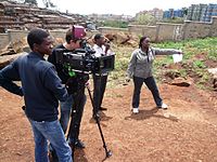 Shooting feature film Togetherness Supreme in Kibera and with the collaboration with Kibera youth trainees
Kibera is featured in Fernando Meirelles's film The Constant Gardener, which is based on the book of the same name by John le Carré. It is also mentioned in the music video "World on Fire" by Sarah McLachlan, which profiled the work of Carolina for Kibera, a grassroots organization named a Hero of Global Health in 2005 by Time Magazine.[21]
Robert Neuwirth devotes a chapter of his book Shadow Cities to Kibera and calls it a squatter community, predicting that places like Kibera, Sultanbeyli in Istanbul, Turkey, and Dharavi in Mumbai, India, are the prototypes of the cities of tomorrow. Among other things, Neuwirth points out that such cities should be reconsidered and not viewed merely as slums, because many locals were drawn to them while escaping far worse conditions in rural areas. Michael Holman's 2005 novel Last Orders at Harrods is based on a fictional version of the slum, called Kireba. Bill Bryson visited Africa for CARE and wrote a companion book called "Bill Bryson's African Diary", which includes a description of his visit to Kibera.
Kibera is also the backdrop for the award-winning short film Kibera Kid, which featured a cast entirely drawn from Kibera residents. The film has played in film festivals worldwide including the Berlin Film Festival and won a Student Emmy from Hollywood. Recently, Hot Sun Foundation and Hot Sun Films started the first film school in the slum, the Kibera Film School. The film school teaches the youth from the slum how to make films and tell their stories. In 2009 through 2010, the Kibera Film School and Hot Sun Foundation collaborated on the feature film follow-up to Kibera Kid, which is titled Togetherness Supreme. In his documentary Living with Corruption, Sorious Samura stayed with a family in Kibera to film the corruption that occurs even at the lowest levels of Kenyan society. Furthermore, Kibera is portrayed in the Austrian 2007 documentary Über Wasser: Menschen und gelbe Kanister.
See also
References
- ^ Affordable Housing Institute blog
- ^ a b c d A Trip Through Kenya’s Kibera Slum
- ^ a b Participating countries
- ^ a b Machetes, Ethnic Conflict and Reductionism The Dominion
- ^ a b Karanja, Muchiri (3 September 2010). "Myth shattered: Kibera numbers fail to add up". Daily Nation. http://www.nation.co.ke/News/Kibera%20numbers%20fail%20to%20add%20up/-/1056/1003404/-/13ga38xz/-/index.html. Retrieved 4 September 2010.
- ^ de Smedt, Johan (2009). Kill Me Quick, A History of Nubian Gin in Kibera. International Journal of African Historical Studies. http://findarticles.com/p/articles/mi_7573/is_200905/ai_n42041066/. Retrieved 21 November 2011.
- ^ Lowder, Stella (1986). The geography of Third World cities. Totowa, N.J.: Barnes Noble Books. ISBN 0-389-20671-7.
- ^ Cite error: Invalid
<ref>tag; no text was provided for refs namedecon; see Help:Cite errors/Cite error references no text - ^ M.Davis, (2006) The Planet of Slums
- ^ International Housing Coalition (2007), Urban Investments and Rates of Return: Assessing MCC’s Approach to Project Evaluation.
- ^ UN-Habitat, Water and Sanitation Programme (Vacutug Development project - Participating Countries)
- ^ UN-Habitat, Water and Sanitation Programme (Vacutug Development project - Phases)
- ^ UN-Habitat (2004), Africa on the Move. An urban crisis in the making
- ^ IRIN Humanitarian news and analysis. A project of the UN Office for the Coordination of Humanitarian Affairs (09/13/2006), "KENYA: Kibera, The Forgotten City"
- ^ Map Kibera Project
- ^ This estimation is based on Kianda's population density of 95,120 people per square Km (246,360 people per square mile), multiplied by the area of the whole slum (2.5 square Km = 0.9 square miles), taking into account 1) that type, dimension and distribution of the buildings observed in Kianda is typically the same in the whole Kibera, and 2) an additional 7% estimated error. Nonetheless, no estimation so far guessed by the MKP, or the UN, or the GoK or by other actors can be taken for granted and does not represent the real dimension of the population of Kibera. In general, no estimation can be proved nor refuted until an exhaustive census will be taken throughout the whole slum.
- ^ a b c d e f g "Kenya begins huge slum clearance". BBC. 16 September 2009. http://news.bbc.co.uk/1/hi/world/africa/8258417.stm. Retrieved 17 September 2009.
- ^ a b c d e "Kenya moves 1,500 slum residents to new homes". The Standard. 16 September 2009. http://www.google.com/hostednews/ap/article/ALeqM5i2mIs1YGVZOqru3LLXpzLNtLJDnQD9AOF4C00. Retrieved 17 September 2009.
- ^ a b c "Ecstasy as Kibera slum residents finally reach 'promised land' after years of waiting". The Standard. 16 September 2009. http://www.eastandard.net/InsidePage.php?id=1144024186&cid=4. Retrieved 17 September 2009.
- ^ http://www.state.gov/g/drl/rls/hrrpt/2005/61575.htm
- ^ Yunus Ndeti - A Brief History of Kibera, 2003
External links
- Clean Water for Kenyans: Multimedia story on Water Sanitation Projects in Kibera
- BBC News: Nairobi Slum Life
Categories:- Suburbs of Nairobi
- Shanty towns
- Slums in Africa


Wikimedia Foundation. 2010.