- Arusha Region
-
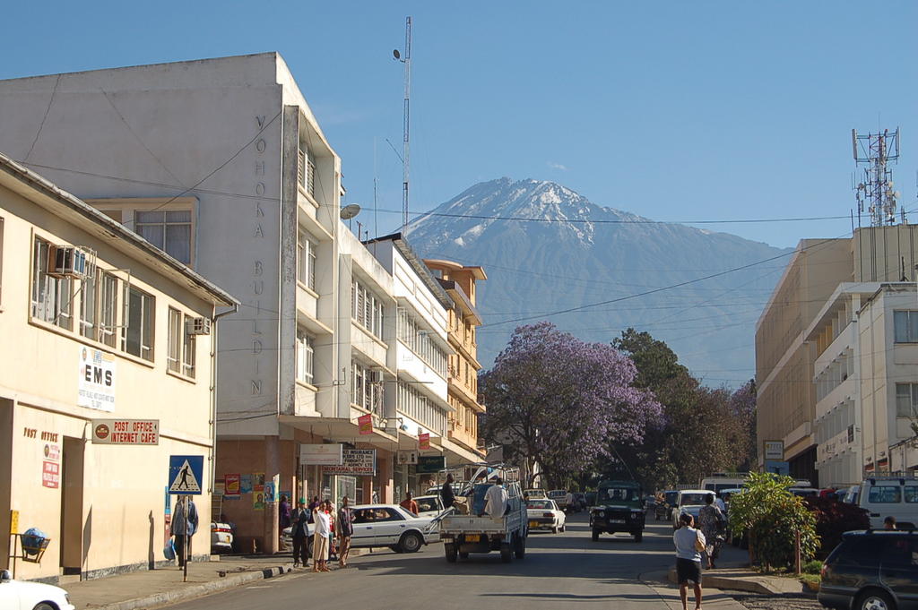
Arusha — Region — Central Arusha City with Mount Meru in the background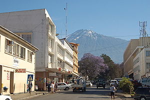 Location of Arusha Region in Tanzania
Coordinates: 3°0′S 36°0′E / 3°S 36°ECoordinates: 3°0′S 36°0′E / 3°S 36°E Country  Tanzania
Capital Arusha Government – Regional commisioner Isidore Leka Shirima Population (2002) – Total 1,288,088 Time zone EAT (UTC+3) – Summer (DST) not observed (UTC+3) Arusha is one of Tanzania's 26 administrative regions. The regional capital and largest city is Arusha. Other towns include Monduli, just west of Arusha, Longido and Loliondo to the north, Mto Wa Mbu and Karatu to the west and Usa River to the east. The region is divided into these districts: Ngorongoro, Arusha, Karatu, Monduli, Longido and Arumeru.
Contents
Overview
The region is a popular tourist destination and is the centre of the Northern Tanzania Safari Circuit. Ngorongoro Crater, in the western part of the region, drew 250,000 visitors in 2004. Nearby national parks include Serengeti (most of which is in Mara Region), Arusha, Tarangire and Lake Manyara (in Manyara Region). Kilimanjaro (in Kilimanjaro Region) is 44 miles east of Mount Meru. Remains of a 1,000-year-old stone structure are found at Engaruka.
The Great Rift Valley cuts right through the middle of the region north-to-south. Oldonyo Lengai (Mountain of God in Maasai language) is an active volcano to the north of Ngorongoro. Altitudes throughout the region vary widely, but much of it ranges from 900 to 1600 metres (3,000 to 5,500 feet in elevation. Mt. Meru, the second highest mountain in Tanzania after Kilimanjaro, peaks at 4,655 metres (14,980 feet). Other geographical features include the Lelatema Mountains and the Umba Valley.
The city of Arusha is at the southern foot of Mt. Meru. Areas to the south and southeast of the mountain tend to be sufficiently watered and are the most densely populated areas of the region.
Most people here speak Swahili and their tribal language. Many also speak English.
The Maasai are the most influential tribe in the region. The Arusha and Meru people live near Mt. Meru. Rwa, Mbulu, Iraqw, Temi, and Mbugwe are also present in smaller areas. The city of Arusha is currently undergoing urbanization, which is drawing people of many tribes from throughout the country to live there.
According to the 2002 Tanzania National Census, the population of the Arusha Region was 1,292,973. [1]
Portions of the former Arusha Region districts of Kiteto, Babati, Mbulu, Hanang, and a tiny piece of Monduli were incorporated into the recently formed Manyara Region -- immediately south of Arusha Region.
The Arusha regional commissioner is Isidore Leka Shirima.
Districts
Wilaya za Mkoa wa ArushaArumeru 514,651 2,896 Arusha 281,608 93 Karatu 177,951 3,300 Monduli 110,442 6,419 Ngorongoro 129,362 14,036 Total 1,288,088 34,526 2002 Longido: 7,782 km²;
Idadi ya wakazi: 74,074Marejeo: Mkoa wa Arusha Transportation
Main article: Transport in TanzaniaMost roads are unpaved, but there are three main paved highways.
The first runs into the region from the east near Kilimanjaro International Airport. It runs east-west through the city of Arusha, then curves northward around Mt. Meru and continues on to Nairobi, Kenya. It is commonly called the Nairobi road.
The second begins in Arusha and goes west, through Kisongo, through Meserani, and past Monduli. After about 50 miles near Mto wa Mbu, the road begins curving southward around Lake Manyara and continues on to Babati and Dodoma. It is commonly called the Dodoma roads.
The third is a new highway from the Dodoma road near Mto wa Mbu to Ngorongoro Crater. It accommodates many tourists and passes through Mto wa Mbu and Karatu before ascending to the crater.
Arusha region is landlocked and there are no navigable rivers. The larger lakes in the Rift Valley are not used for transportation.
Kilimanjaro International Airport, which serves the cities Moshi and Arusha, is a gateway for tourists and business. Among its carriers are Air Tanzania, Precision Air, Ethiopian Airlines, Kenya Airways, and KLM.
Most overland travel is done by bus from the city of Arusha. Within town, mini-buses called dala-dalas jockey for passengers.
There are also many "unofficial" taxiing services that center around tourist hubs (hotels and markets for example). As with anything of this nature, it is best to be careful with their services. Usually, the ones offering rides from inside the gate of the hotels are genuine taxi drivers, while those outside may be more suspect.
Named roads
The road referred to as Nairobi Road is Arusha-Moshi Road, as it joins the two districts. The Nairobi Road is the one that passes through Ngarenaro, eventually joining the Arusha-Moshi road. They then join and continue with one name 'Nairobi Road' as they head towards Sakina, Azimio, Ngaramtoni and eventually Nairobi.
The "Dodoma Road" ceased to be in the 1980s when Tanzania lost its then Prime Minister, Honorable Edward Moringe Sokoine. The road was renamed "Sokoine Road" in his honour as it leads to his home village
See also
Sources
- Arusha Region Homepage for the 2002 Tanzania National Census
- Tanzanian Government Directory Database
- Language maps for eastern Tanzania
Regions of Tanzania Arusha · Dar es Salaam · Dodoma · Iringa · Kagera · Kigoma · Kilimanjaro · Lindi · Manyara · Mara · Mbeya · Morogoro · Mtwara · Mwanza · North Pemba · Pwani · Rukwa · Ruvuma · Shinyanga · Singida · South Pemba · Tabora · Tanga · Zanzibar Central/South · Zanzibar North · Zanzibar Urban/West
 Categories:

Wikimedia Foundation. 2010.