- Serengeti
-
For other uses, see Serengeti (disambiguation).
 Map of Tanzania showing national parks
The Serengeti ecosystem is a geographical region in Africa. It is located in north Tanzania and extends to south-western Kenya between latitudes 1 and 3 S and longitudes 34 and 36 E. It spans some 30,000 km2 (12,000 sq mi).
The Serengeti hosts the largest mammal migration in the world, which is one of the ten natural travel wonders of the world.[1]
The region contains several national parks and game reserves. Serengeti is derived from the Maasai language, Maa; specifically, "Serengit" meaning "Endless Plains".[2][3]
Approximately 70 larger mammal and some 500 avifauna species are found there. This high diversity in terms of species is a function of diverse habitats ranging from riverine forests, swamps, kopjes, grasslands and woodlands.[4] Blue Wildebeests, gazelles, zebras and buffalos are some of the commonly found large mammals in the region.
Currently there is controversy surrounding a proposed road that is to be built through the Serengeti in Tanzania.
Contents
History
 Wildebeests on the Serengeti plains during the migration
Much of the Serengeti was known to outsiders as Maasailand. The Maasai were known as fierce warriors, and lived alongside most wild animals with an aversion to eating game and birds, subsisting exclusively on their cattle. Their strength and reputation kept the newly arrived Europeans from exploiting the animals and resources of most of their land. A rinderpest epidemic and drought during the 1890s greatly reduced the numbers of both Maasai and animal populations. Poaching and the absence of fires, which had been the result of human activity, set the stage for the development of dense woodlands and thickets over the next 30–50 years. Tsetse fly populations now prevented any significant human settlement in the area.
Fire, elephants, and wildebeest were influential in determining the current character of the Serengeti.[5] By the 1960s, as human populations increased, fire, either intentionally set by the Maasai to increase area available for pasture, or accidentally, scorched new tree seedlings. Heavy rainfall encouraged the growth of grass, which served as fuel for the fires during the following dry seasons. Older Acacias, which live only 60 to 70 years, began to die. Initially elephants, which feed on both young and old trees, had been blamed for the shrinking woodlands. But experiments showed that other factors were more important. Meanwhile, elephant populations were reduced from 2,460 in 1970 to 467 in 1986 by poaching.[6]
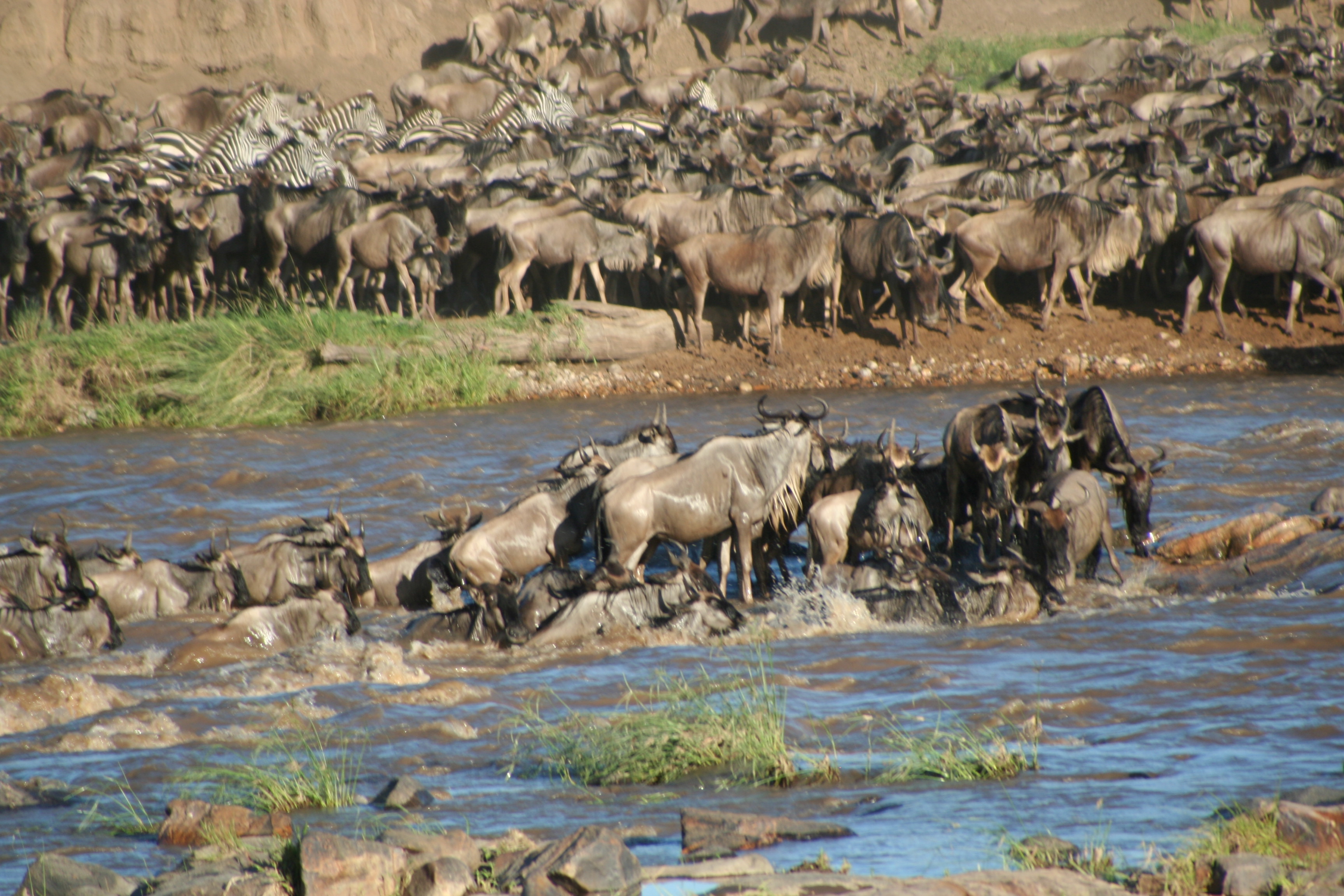
 Wildebeests crossing the river during the Serengeti migration
By the mid 1970s wildebeest and the Cape buffalo populations had recovered, and were increasingly cropping the grass, reducing the amount of fuel available for fires.[7] The reduced intensity of fires has allowed Acacia to once again become established.[5]
Great migration
Each year around the same time the great wildebeest migration begins in the Ngorongoro area of the southern Serengeti of Tanzania. A natural phenomenon determined by the availability of grazing. It is January to March when the calving season begins. A time when there is plenty of rain ripened grass available for the 500,000 zebra that precede 1.8 million wildebeest and the following 100,000 plains game.
February marks the start of this great migration, preceding the long rainy season when wildebeest spend their time grazing and giving birth to approximately 500,000 calves within a 2 to 3 week period, which starts abruptly and is remarkably synchronized. Few calves are born ahead of time, the few that are as much as 6 months out of phase, hardly any will survive. (Estes 1992)[citation needed] The main reason for this being that very young calves are more noticeable to predators when mixed with older calves from earlier in the previous year, and so are easier prey.
Around October-December, nearly two million herbivores travel from the northern hills toward the southern plains in pursuit of the rains. In April, they then return to the north by travelling east-west, crossing the Mara River in July-September. This phenomenon is sometimes called the Circular Migration, and follows an anti-clockwise direction.
Some 250,000 wildebeest die during the journey from Tanzania to Maasai Mara Reserve in lower Kenya, a total of 800 kilometres (500 mi). Death is usually from thirst, hunger, exhaustion, or predation.[1] The migration is chronicled in the 1994 documentary film, Africa: The Serengeti. The second-largest is the South Sudan animal migration.
Ecology
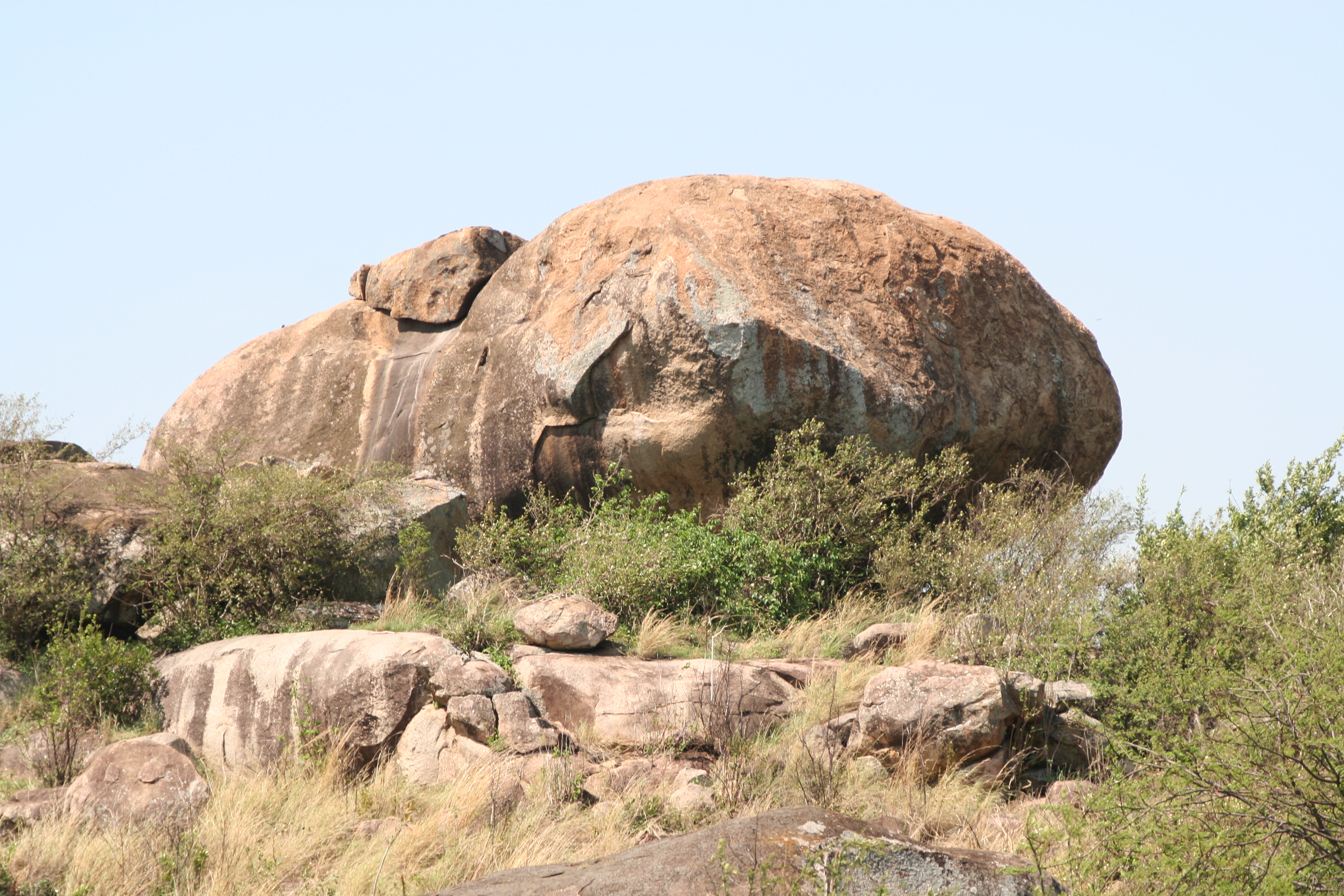
 Kopjes, or rock outcroppings, on the Serengeti plain.
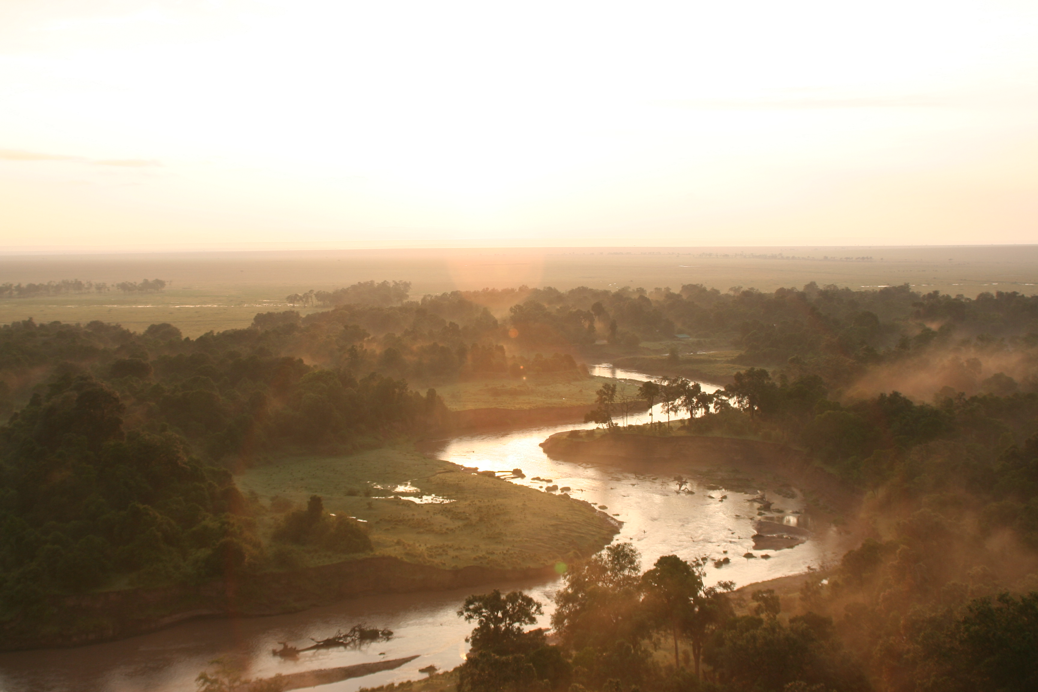
 River and the Serengeti plains.
Maasailand has East Africa's finest game areas.[8] The governments of Tanzania and Kenya maintain a number of Protected Areas: parks, conservation areas, game reserves, etc. that give legal protection to over 80% of the Serengeti.[4]
Ol Doinyo Lengai, the only active volcano in the area of the Serengeti, is the only volcano that still ejects carbonatite lavas. This material, upon exposure to air, changes from black to white and resembles washing soda. A thick layer of ash can turn into a calcium rich hardpan as tough as cement after being rained upon. Tree roots cannot penetrate this layer, and the essentially treeless plains of the Serengeti, which lie to the west and down wind of Ol Doinyo Lengai, are the result.[9]
The southeastern area lies in the rain shadow of the Ngorongoro highlands and is composed of shortgrass treeless plains with abundant small dicots. Soils are high in nutrients, overlying a shallow calcareous hardpan. A gradient of soil depth northwestward across the plains results in changes in the herbaceous community and taller grass. Some 70 km (43 mi) west, Acacia woodlands appear suddenly and stretch west to Lake Victoria and north to the Loita Plains, north of the Maasai Mara National Reserve. The 16 Acacia species vary over this range, their distribution determined by edaphic conditions and soil depth. Near Lake Victoria there are flood plains developed from ancient lakebeds. In the far northwest, Acacia woodlands are replaced by broadleaved Terminalia-Combretum woodlands, determined by a change in geology.
This area has the highest rainfall in the system and forms a refuge for the migrating ungulates at the end of the dry season.[10][11]
Altitudes in the Serengeti range from 920 to 1,850 metres (3,020 to 6,070 ft) with mean temperatures varying from 15 to 25 degrees Celsius. Although the climate is usually warm and dry, rainfall occurs in two rainy seasons: March to May, and a shorter season in October and November. Rainfall amounts vary from a low of 508 mm (20 in) in the lee of the Ngorongoro Highlands to a high of 1,200 mm (47 in) on the shores of Lake Victoria.[12] The highlands, which are considerably cooler than the plains and are covered by montane forest, mark the eastern border of the basin in which the Serengeti lies.
The Serengeti plain is punctuated by granite outcroppings known as kopjes. These outcroppings are the result of volcanic activity. Kopjies provide a microhabitat for non-plains wildlife. One kopje likely to be seen by visitors to the Serengeti is the Simba Kopje (Lion Kopje). The Serengeti was used as inspiration for the animated Disney feature film The Lion King and subsequent theatrical production.
The area is also home to the Ngorongoro Conservation Area, which contains the Olduvai Gorge, where some of the oldest hominid fossils are found, as well as the Ngorongoro Crater.
References
- ^ a b Partridge, Frank (2006-05-20). "The fast show". The Independent (London). http://www.findarticles.com/p/articles/mi_qn4158/is_20060520/ai_n16416123. Retrieved 2007-03-14.
- ^ Briggs, Phillip (2006), Northern Tanzania: The Bradt Safari Guide with Kilimanjaro and Zanzibar, Bradt Travel Guides, p. 198, ISBN 9781841621463
- ^ "Maa (Maasai) Dictionary". Darkwing.uoregon.edu. http://darkwing.uoregon.edu/~dlpayne/Maa%20Lexicon/index-english/main.htm. Retrieved 2010-10-23.
- ^ a b www.ath.aegean.gr/srcosmos/showpub.aspx?aa=8868[dead link]
- ^ a b Sinclair, Anthony Ronald Entrican; Arcese, Peter, eds (1995). Serengeti II: Dynamics, Management, and Conservation of an Ecosystem. University of Chicago Press.. pp. 73–76. ISBN 9780226760322. http://books.google.com/books?id=qSb-dHu7rGQC&pg=PA73&lpg=PA73&dq=acacia+trees+serengeti+fire. Retrieved 2010-10-23.
- ^ Sinclair, p. 76.
- ^ Morell, Virginia (1997), "Return of the Forest", Science 278 (5346): 2059, doi:10.1126/science.278.5346.2059
- ^ Pavitt, Nigel (2001), Africa's Great Rift Valley, Harry N. Abrams, p. 122, ISBN 9780810906020
- ^ Pavitt 2001, pp. 130, 134.
- ^ Sinclair, A. R. E.; Mduma, Simon A. R.; Fryxell, John M. (2008), Serengeti III: Human Impacts on Ecosystem Dynamics, Chicago: University of Chicago Press, p. 11, ISBN 9780226760339
- ^ Sinclair, A. R. E.; Mduma, S. A.; Hopcraft, J. G.; Fryxell, J. M.; Hilborn, R.; Thirgood, S. (2007), "Long-Term Ecosystem Dynamics in the Serengeti: Lessons for Conservation", Conservation Biology 21 (3): 580–590, doi:10.1111/j.1523-1739.2007.00699.x, http://ib.cbs.uoguelph.ca/pdfs/Sinclair_2007_ConsBiol.pdf
- ^ "The Serengeti National Park". Glcom.com. http://www.glcom.com/hassan/serengeti.html. Retrieved 2010-10-23.
See also
- Kenya
- Tanzania
- Africa
- List of topics related to Africa
- Maasai mythology
External links
Categories:- Grasslands of Kenya
- Afrotropic
- Tropical and subtropical grasslands, savannas, and shrublands
- Grasslands of Tanzania


Wikimedia Foundation. 2010.