- Arumeru
-
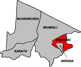
Arumeru — District — Map of Arusha Region's Districts with Arumeru highlighted.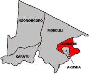
Country Tanzania Region Arusha Region Population (2002) - Total 516,814 Arumeru is one of the five districts in the Arusha Region of Tanzania. It is bordered to the north and west by the Monduli District, to the east by the Kilimanjaro Region and to the south by the Arusha District and the Monduli District.
According to the 2002 Tanzania National Census, the population of the Arumeru District was 516,814. [1]
Wards
The Arumeru District is administratively divided into 37 wards:
- Akheri
- Bangata
- Bwawani
- Ilkiding'a
- Kikatiti
- Kikwe
- Kimnyaki
- King'ori
- Kiranyi
- Kisongo
- Leguruki
- Makiba
- Maji ya Chai (English meaning: tea water)
- Maroroni
- Mateves
- Mbuguni
- Mlangarini
- Moivo
- Moshono
- Murieti
- Musa
- Mwandeti
- Nduruma
- Ngarenanyuki
- Nkoanrua
- Nkoaranga
- Nkoarisambu
- Oldonyosambu
- Oljoro
- Olkokola
- Oltroto
- Oltrumet
- Poli
- Singisi
- Sokoni II
- Songoro
- Usa River
Sources
See also
- Districts of Tanzania
- Arusha Region
- Arusha District
- Monduli District
- Ngorongoro District
- Karatu District
Arumeru District Wards Akheri • Bangata • Bwawani • Ilkiding'a • Kikatiti • Kikwe • Kimnyaki • King'ori • Kiranyi • Kisongo • Leguruki • Makiba • Maji ya Chai • Maroroni • Mateves • Mbuguni • Mlangarini • Moivo • Moshono • Murieti • Musa • Mwandeti • Nduruma • Ngarenanyuki • Nkoanrua • Nkoaranga • Nkoarisambu • Oldonyosambu • Oljoro • Olkokola • Oltroto • Oltrumet • Poli • Singisi • Sokoni II • Songoro • Usa RiverCategories:- Arusha Region geography stubs
- Arumeru District
- Arusha Region
Wikimedia Foundation. 2010.