- Connolly, Western Australia
-
This article is about the suburb within Perth, Western Australia. For other uses, see Connolly (disambiguation).
Connolly
Perth, Western Australia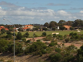
Connolly & the Joondalup Golf Resort
 Connolly
Population: 3,671 (2006 census)[1] Established: 1980s Postcode: 6027 Area: 2.8 km² (1.1 sq mi) Location: 26 km (16 mi) NNW of Perth City LGA: City of Joondalup State District: Joondalup Federal Division: Moore Suburbs around Connolly: Iluka Currambine Joondalup Ocean Reef Connolly Joondalup Ocean Reef Heathridge Joondalup Coordinates: 31°45′14″S 115°45′58″E / 31.754°S 115.766°E
Connolly is a northern suburb of Perth, Western Australia, located within the City of Joondalup adjacent to Joondalup's central business district. It was built in the late 1980s as a golf course estate. Its eastern border backs onto the Mitchell Freeway road reserve. Many homes feature on the edges of Connolly but the homes bordering the golf course are generally larger and more affluent.
The suburb was named in honour of John Connolly who held land in the area in 1838. Connolly was a private in the 63rd Regiment who arrived in the colony in 1829 and who farmed at Upper Swan and Bindoon after being discharged in 1834.[2]
Contents
Geography
Connolly is bounded by Shenton Avenue to the north, the Mitchell Freeway road reserve to the east, Hodges Drive to the south, and Marmion Avenue to the west.
Education
The suburb is served by a single primary school, Connolly Primary School located on the eastern side of the suburb. Government school students attend different high schools based upon which side of the golf course they reside. Those on the western side attend Ocean Reef Senior High School, while those in the east attend Belridge Senior High School. Some students opt to attend Lake Joondalup Baptist College or Prendiville Catholic College, both independent schools.
Significant events
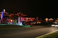 Prairie Dunes Place at night, Christmas 2007.
An entire local street, namely Prairie Dunes Place has gained notability for its annual Christmas lights display.[3][4] Since 1999, the street has been raising funds for the Association of the Blind WA and in this time has raised in excess of $80,000 [AUD] (2007) towards the training of guide dogs.[5][6]
Transport
The suburb is served by bus links which provide connections back to the Joondalup Line via either the Whitfords or Joondalup railway stations.
Bus routes
- 460 Whitfords - Joondalup
- 461 Whitfords - Joondalup
- 462 Whitfords - Joondalup
- 470 Whitfords - Joondalup
References
- ^ Australian Bureau of Statistics (25 October 2007). "Connolly (State Suburb)". 2006 Census QuickStats. http://www.censusdata.abs.gov.au/ABSNavigation/prenav/LocationSearch?collection=Census&period=2006&areacode=SSC51316&producttype=QuickStats&breadcrumb=PL&action=401. Retrieved 2008-10-05.
- ^ Western Australian Land Information Authority. "History of metropolitan suburb names". http://www.landgate.wa.gov.au/corporate.nsf/web/History+of+metropolitan+suburb+names. Retrieved 2007-05-15.
- ^ "Community Wellbeing" (PDF). City of Joondalup. http://www.joondalup.wa.gov.au/cms/fileDisplay.asp?file=918. Retrieved 2007-12-31.[dead link]
- ^ "City hosts Christmas lights walk" (PDF). City of Joondalup. 6 December 2006. http://www.joondalup.wa.gov.au/BUmarketing/news/releases/City%20of%20Joondalup%20hosts%20free%20Christmas%20lights%20walk.pdf.
- ^ "News - Lighting up Christmas – Dec 2007". Association for the Blind (WA). Archived from the original on 2007-08-31. http://web.archive.org/web/20070831100928/http://www.guidedogswa.com.au/news.htm. Retrieved 2007-12-31.
- ^ "Guide Dog Supporters". Association for the Blind (WA). http://www.abwa.asn.au/guidedogsupporters.htm. Retrieved 2007-12-31.
Suburbs of the City of Joondalup | Perth | Western Australia North Burns Beach · Connolly · Currambine · Edgewater · Heathridge · Iluka · Joondalup · Kinross · Ocean Reef
South ¹ Suburb shared with other Local Government Areas Categories:- Suburbs of Perth, Western Australia
- Joondalup
- Perth, Western Australia geography stubs


Wikimedia Foundation. 2010.