- Flint River (Michigan)
-
Flint River 
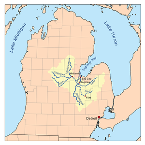
The Flint River WatershedOrigin Lapeer County Mouth Saginaw River Basin countries Michigan,  United States
Length 142 mi (229 km) Basin area Saginaw River watershed - For other rivers named Flint, see Flint River (disambiguation page).
The Flint River is a river in the Flint/Tri-Cities region of Michigan, 142 mi (229 km) long, that flows through the city of Flint and the counties of Genesee, Lapeer and Saginaw.
Contents
Course
The Flint River drains 1,332 sq mi (3,449.8 km²) of Michigan, mostly in the counties of Lapeer, Genesee, Shiawassee, and Saginaw. It also drains parts of Oakland, Tuscola, and Sanilac.
The river is formed in Lapeer County near Columbiaville where the river's South Branch and North Branch come together. The river is supplemented by four major creeks, the Kearsley (draining the south and central portions of the east side of Genesee County), Thread (draining the south central part of the county), Swartz (draining the Swartz Creek area), and Misteguay (draining the area near the northern section of the border of Genesee and Shiawassee Counties).
The river empties into the Shiawassee River in the Shiawassee National Wildlife Refuge near the city of Saginaw. Within the refuge, the Cass and Tittabawassee combine with the Shiawassee to form the Saginaw River. The Saginaw empties into the Saginaw Bay of Lake Huron.
Features along the Flint River
The river is dammed in Richfield Township to form the Holloway Reservoir, which was formed in 1953 and fully completed 1955. The reservoir was constructed, originally, as a water supply for Flint, and to move the river through the city more quickly to dilute sewage.[1] By 1967, though, the city got its drinking water from Lake Huron, and only uses it as an emergency back-up water supply.
The C.S. Mott Dam just five miles (8 km) downstream and west of Genesee forms Mott Lake and was completed in 1972 for recreational use. Local attractions along the lake include Crossroads Village, Huckleberry Railroad, and Stepping Stone Falls, and the riverboat Genesee Belle.
The next dam is the Utah Dam. A largely steel dam, it was completed in 1928 to prevent industrial discharges from entering the drinking water supply downstream. The gates have since been locked in the open position so that it no longer impedes the flow of the river.
The Hamilton Dam exists downstream at the University of Michigan–Flint campus in downtown Flint. Constructed in 1920, it also once serves as a pedestrian bridge, but is now in severe disrepair. Because of its dilapidation, The Michigan Department of Enivronmental Quality ordered that steps be taken by 2008, and if that did not occur that the river be lowered to reduce the use of the dam.[2] In 2008, the city of Flint spent $30,000 on a pre-engineering study to assess whether a new dam was needed or the old one be repaired.
Finally, downstream from the Hamilton Dam is an infatable dam just west of the Grand Traverse Street Bridge. The Fabridam was completed in 1979 mostly for visual and recreational purposes as it impounds very little of the river. It was replaced in 2001 with a $604,000 Obermeyer Hydro Inc. dam.[3]
In the city of Flint, the river flows past the sites of former General Motors factories, most notably Chevrolet's first assembly plant, which was bisected by the river, and downtown through the campus of the University of Michigan–Flint and Riverbank Park. Continuing to the west, the river runs past Kettering University and McLaren Hospital out into Flint Township and Flushing. The stretch of the Flint River from downtown Flint to Kettering University is channelized with concrete sides. In Downtown Flint, the Flint Carriage Factory is on the river, which was later Dort Motors, a predecessor to General Motors. The Durant-Dort Carriage Company Office, now a historic landmark, is across the street.
A recreational trail called the Flint River Trail runs along the river from Grand Traverse Street in Downtown Flint to Carpenter Road on one side and Johnson Elementary School on Pierson Road on the other. It is a paved path, except behind the Flint Water Plant. North of Carpenter Road, the trail connects to the Mott Lake Trailway, which goes to Bluebell Beach on Bray Road and Stepping Stone Falls on Branch Road in Genesee Township. Another portion of the Mott Lake Trailway runs alongside the lake from the corner of Center Road and Coldwater Road to the corner of Genesee Road and Stanley Road. Together, the trails run 21.5 miles (34.6 km). An organization named Friends of the Flint River Trail maintains it, in addition to the Genesee County Parks & Recreation Commission and Flint Parks & Recreation Department. [4] [5]
Northwest of Flint, a city park in Flushing lies on the river, as well as the recreational Flushing River View Trail.
Cities and villages along the river
- Montrose, Michigan
- Flushing, Michigan
- Flint, Michigan
- Genesee, Michigan
- Columbiaville, Michigan
- Lapeer, Michigan
References
- ^ Holloway Reservoir, Genesee & Lapeer counties (T8N, R8, 9E, Section Many), by William C. Bryant, Michigan Department of Natural Resources, Status of the Fishery Resource Report 92-1, 1992.
- ^ Flint's Hamilton Dam under the microscope for repairs, The Flint Journal, by Elizabeth Shaw, published Friday February 22, 2008
- ^ Around the Corps Newsletter, January 2001, accessed October 1, 2008
- ^ Friends of the Flint River Trail Homepage
- ^ Map of the Flint River Trail
External links
- Flint River assessment.
- Maps and graphs of Michigan water resources conditions
- USGS Water Data Flint River water data near Otisville
- USGS Water Data Flint River near Flint
- Flint River Watershed Coalition
- USGS water data for the Flint River near its terminus
Categories:- Rivers of Michigan
- Geography of Genesee County, Michigan
- Geography of Lapeer County, Michigan
- Geography of Saginaw County, Michigan
Wikimedia Foundation. 2010.

