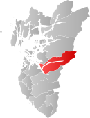
- Forsand
-
Forsand kommune — Municipality — Lysebotn, located at the head of the Lysefjord 
Coat of arms
Rogaland within
NorwayForsand within Rogaland Coordinates: 59°0′N 6°30′E / 59°N 6.5°ECoordinates: 59°0′N 6°30′E / 59°N 6.5°E Country Norway County Rogaland District Ryfylke Administrative centre Forsand Government – Mayor (2008) Ole Tom Guse (KrF) Area – Total 842 km2 (325.1 sq mi) – Land 702 km2 (271 sq mi) Area rank 139 in Norway Population (2004) – Total 1,069 – Rank 403 in Norway – Density 2/km2 (5.2/sq mi) – Change (10 years) 3.3 % Demonym Forsandbu[1] Time zone CET (UTC+1) – Summer (DST) CEST (UTC+2) ISO 3166 code NO-1129 Official language form Nynorsk Website www.forsand.kommune.no Data from Statistics Norway Forsand is a municipality in Rogaland county, Norway. Forsand was separated from Høle on 1 January 1871. In 1999, evidence of a population here dating back to around 7500 BC was located.
Forsand is located within the constraints of two fjords, Lysefjord and Høgsfjord. It is one of largest municipalities within the county of Rogaland in terms of area, and one of the smallest in terms of population. Forsand municipality covers 842 km² and has a population of 1,116 (2008).[2]
Contents
General information
Name
The municipality (originally the parish) is named after the old Forsand farm (Old Norse: Forsandr), since the first church was built there. The first element is the prefix for which means "outsticking" and the last element is sandr which means "sand" or "sandy beach". Before 1918, the name was written "Fossan".
Coat-of-arms
The coat-of-arms is from modern times. They were granted on 11 March 1988. The arms show a silver heron on a green background. They were designed by John Digernes.[3]
Villages
Villages that are part of the municipality:
- Forsand 58°54′0″N 6°5′30″E / 58.9°N 6.09167°E
- Fløyrli at 59°1′0″N 6°26′0″E / 59.016667°N 6.433333°E
- Kolabygda at 58°56′33″N 6°1′15″E / 58.9425°N 6.02083°E
- Lysebotn, located in the end of the Lysefjord, at 59°3′16″N 6°38′52″E / 59.05444°N 6.64778°E
- Øvre Espedal at 58°55′3″N 6°16′17″E / 58.9175°N 6.27139°E
References
- ^ "Personnemningar til stadnamn i Noreg" (in Norwegian). Språkrådet. http://www.sprakrad.no/nb-no/Sprakhjelp/Rettskrivning_Ordboeker/Innbyggjarnamn/.
- ^ "Figures on Forsand Municipality". Statistisk sentralbyrå. 2008. http://www.ssb.no/english/municipalities/1129. Retrieved 2008-10-08.
- ^ "Kommunevåpen". 2006. http://www.forsand.kommune.no/artikkel.aspx?AId=331&back=1&MId1=7&MId2=36&MId3=209. Retrieved 2008-10-08. (Norwegian)
External links
Categories:- Municipalities of Rogaland
- Villages in Rogaland
- Forsand
Wikimedia Foundation. 2010.


