- Miri Division
-
Miri 
Divisions of Sarawak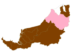
Division Office location Miri Local area government (s) Majlis Bandaraya Miri (MBM)
Majlis Daerah Subis (MDS)
Majlis Daerah Marudi (MDM)Area - Total 26,777.1 km2 (10,338.7 sq mi) Population (2000) - Total 316,400 - Density 11.8/km2 (30.6/sq mi) Resident -- License plate prefix QM Miri Division is one of the eleven administrative divisions of Sarawak, east Malaysia, on the island of Borneo. It has a total area of 26,777.1 square kilometers, and is the second largest division after Kapit Division.
The population of Miri Division (year 2000 census) was 316,400. Ethnically, the population was Iban, Chinese, Malay, Melanau, Kayan, Kenyah, Lun Bawang and Kelabit. Due to the petroleum industry, there is also a large foreign worker population.
Miri Division consists of two districts: Miri and Marudi.
The economy is largely based on petroleum and natural gas extraction from both onshore and offshore wells, and related petroleum refining, liquified natural gas and chemical production. Another major industry is timber processing from Miri's huge tropical rainforest. Processed wood products, rather than log export has been given priority by the government. Agriculture is includes oil palm, rubber, and pepper as the main products. Tourism, particularly ecotourism, is a growing component of the economy.
Links:
 Sarawak
Divisions Betong Division · Bintulu Division · Kapit Division · Kuching Division · Limbang Division · Miri Division · Mukah Division · Samarahan Division · Sarikei Division · Sibu Division · Sri Aman DivisionCities Districts Sub-Districts SebauhTowns Asajaya · Ba'kelalan · Bau · Beladin · Betong · Bintangor · Bintulu · Daro · Dalat · Debak · Engkilili · Julau · Kanowit · Kapit · Kota Samarahan · Lawas · Limbang · Lingga · Lubok Antu · Lundu · Maludam · Matu · Mukah · Marudi · Oya · Pakan · Pusa · Saratok · Sebuyau · Selangau · Serian · Serikin · Sibu · Siburan · Simunjan · Spaoh · Sungai Tujuh · Tanjung Kidurong · Tatau · TebeduCategories:- Divisions of Sarawak
- Sarawak geography stubs


Wikimedia Foundation. 2010.