- Pilot Point Airport
-
Pilot Point Airport 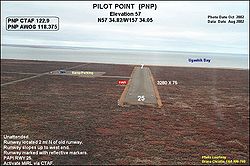
View from east, looking west IATA: PIP – ICAO: PAPN – FAA LID: PNP Summary Airport type Public Owner State of Alaska DOT&PF - Central Region Serves Pilot Point, Alaska Elevation AMSL 57 ft / 17 m Coordinates 57°34′49″N 157°34′19″W / 57.58028°N 157.57194°W Runways Direction Length Surface ft m 7/25 3,280 1,000 Gravel Statistics (2005) Aircraft operations 5,300 Enplanements (2008) 738 Source: Federal Aviation Administration[1][2] Pilot Point Airport (IATA: PIP, ICAO: PAPN, FAA LID: PNP) is a state-owned, public-use airport located in Pilot Point,[1] a city in the Lake and Peninsula Borough of the U.S. state of Alaska. Scheduled airline service to King Salmon Airport is provided by Peninsula Airways (PenAir).[3]
As per Federal Aviation Administration records, this airport had 738 commercial passenger boardings (enplanements) in calendar year 2008, an increase of 9% from the 678 enplanements in 2007.[2] Pilot Point Airport is included in the FAA's National Plan of Integrated Airport Systems (2009–2013), which categorizes it as a general aviation facility.[4]
Although most U.S. airports use the same three-letter location identifier for the FAA and IATA, this airport is assigned PNP by the FAA and PIP by the IATA[5] (which assigned PNP to Girua Airport in Popondetta, Papua New Guinea[6]).
Contents
Airlines and destinations
Facilities and aircraft
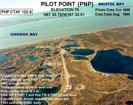
Pilot Point Airport has one runway designated 7/25 with a gravel surface measuring 3,280 by 75 feet (1,000 x 23 m).[1] The airport was previously located at 57°33.79′N 157°33.51′W / 57.56317°N 157.5585°W where it had an 3,100-by-50-foot (940 × 15 m) runway also designated 7/25.[7]
For the 12-month period ending December 31, 2005, the airport had 5,300 aircraft operations, an average of 14 per day: 66% general aviation and 34% air taxi.[1]
Accidents and incidents
On 1 July 1981, Douglas R4D N111ST of United Aircraft Services crashed shortly after take-off while on a flight to Anchorage International Airport, following the failure of the port engine. All three people on board were killed.[8] The aircraft was on a cargo flight laden with fish.[9]
References
- ^ a b c d FAA Airport Master Record for PNP (Form 5010 PDF). Federal Aviation Administration. Effective 27 Aug 2009.
- ^ a b CY 2008 Passenger Boarding and All-Cargo Data (Preliminary). Federal Aviation Administration. Published 15 July 2009.
- ^ a b 2009 Timetables. Peninsula Airways. Retrieved 4 Sep 2009.
- ^ FAA National Plan of Integrated Airport Systems: 2009-2013. Federal Aviation Administration. Published 1 Oct 2008.
- ^ Great Circle Mapper: PIP - Pilot Point, Alaska. Retrieved 4 Sep 2009.
- ^ Great Circle Mapper: AYGR - Popondetta, Papua New Guinea - Girua Airport. Retrieved 4 Sep 2009.
- ^ Annotated aerial photo of Pilot Point Airport (GIF). Federal Aviation Administration, Alaska Region. August 1998.
- ^ "N111ST Accident description". Aviation Safety Network. http://aviation-safety.net/database/record.php?id=19810701-0. Retrieved 24 July 2010.
- ^ "NTSB Identification: ANC81FA074". National Transportation Safety Board. http://www.ntsb.gov/ntsb/brief.asp?ev_id=25088&key=0. Retrieved 24 July 2010.
External links
- Airport diagram for Pilot Point (PNP) (GIF). Federal Aviation Administration, Alaska Region. 10 June 2004
- FAA Terminal Procedures for PNP, effective 20 October 2011
- Resources for this airport:
- AirNav airport information for PNP
- ASN accident history for PIP
- FlightAware airport information and live flight tracker
- SkyVector aeronautical chart for PNP
Categories:- Airports in Lake and Peninsula Borough, Alaska

Wikimedia Foundation. 2010.