- Ophoven Airfield
-
Ophoven Airfield (Y-32)

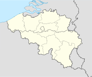
Limburg Province, Belgium Type Military airfield Coordinates 51°08′08″N 005°47′00″E / 51.13556°N 5.7833333°E Built by IX Engineering Command Construction
materialsPierced Steel Planking (PSP) In use December 1944-May 1945 Controlled by United States Army Air Forces Ophoven Airfield is an abandoned World War II military airfield which is located west of Ophoven (Limburg); approximately 54 miles northeast of Brussels.
Contents
History
The airfield was built by the United States Army Air Force IX Engineer Command, 820th Engineer Aviation Battalion in late November/early December 1944.
Known as Advanced Landing Ground "Y-32", the airfield consisted of a single 5000' (1500m) Pierced Steel Planking runway aligned 12/30. In addition, tents were erected for billeting and also for support facilities; an access road was built to the existing road infrastructure; a dump was created for supplies, ammunition, and gasoline drums, along with a drinkable water; and a minimal electrical grid for communications and station lighting was installed.[1]
Opened on 10 December, the airfield was first used as a resupply and casualty evacuation airfield, with C-47 Skytrain transports flying in and out of the airfield frequently. Combat units did not arrive at the airfield until late January 1945, when the 370th Fighter Group, based P-47 Thunderbolt fighters at Ophoven on 27 January. In February, the 405th Fighter Group also based P-47s at the airfield. The fighter planes flew support missions, patrolling roads in front of the beachhead; strafing German military vehicles and dropping bombs on gun emplacements, anti-aircraft artillery and concentrations of German troops when spotted.[2]
Both groups moved out at the end of April 1945, the airfield closed about a month later at the end of May. Today, the airfield is abandoned, being a mixture of agricultural fields just to the west of Ophoven.[3]
See also
References
 This article incorporates public domain material from websites or documents of the Air Force Historical Research Agency.
- ^ IX Engineer Command ETO Airfields, Airfield Layout
- ^ Maurer, Maurer. Air Force Combat Units of World War II. Maxwell AFB, Alabama: Office of Air Force History, 1983. ISBN 0-89201-092-4.
- ^ Johnson, David C. (1988), U.S. Army Air Forces Continental Airfields (ETO), D-Day to V-E Day; Research Division, USAF Historical Research Center, Maxwell AFB, Alabama.
External links
Stations Ben Gardane · Bou Grara · Chekira · Hani · Hazbub · Hergla · El Djem · El Haouaria · Kairouan · Medenine · Menzel Heurr · Sfax · SoltaneUnited Kingdom Aldermaston · Andover · Andrews Field · Ashford · Balderton · Barkston Heath · Beaulieu · Birch · Bisterne · Boreham · Bottesford · Boxted · Charmy Down · Chalgrove · Chilbolton · Chipping Ongar · Christchurch · Cottesmore · Earls Colne · Exeter · Folkingham · Fulbeck · Gosfield · Great Dunmow · Greenham Common · Grove · High Halden · Headcorn · Holmsley South · Hurn · Ibsley · Kingsnorth · Langar · Lashenden · Little Walden · Lymington · Matching · Membury · Merryfield · Middle Wallop · North Witham · Ramsbury · Rivenhall · Saltby · Scorton · Staplehurst · Spanhoe · Stansted · Stoney Cross · Thruxton · Upottery · Warmwell · Welford · Weston Zoyland · Wethersfield · Winkton · WoodchurchEurope Advanced Landing Grounds (ALGs) in France, Belgium, Netherlands and Germany too numerous.
Units Commands 9th Air Division (was IX Bomber Command) · IX Air Defense · IX Fighter · IX Tactical Air · IX Troop Carrier · XIX Tactical Air · XXIX Tactical AirWings Bombardment 97th Bombardment · 98th Bombardment · 99th BombardmentFighter 8th Fighter · 9th Fighter · 70th Fighter · 71st Fighter · 84th Fighter · 100th Fighter · 303d FighterTroop Carrier 50th Troop Carrier · 52d Troop Carrier · 53d Troop CarrierGroups Bombardment 12th Bombardment · 98th Bombardment · 322d Bombardment · 323d Bombardment · 340th Bombardment · 344th Bombardment · 376th Bombardment · 386th Bombardment · 387th Bombardment · 391st Bombardment · 394th Bombardment · 397th Bombardment · 409th Bombardment · 410th Bombardment · 416th BombardmentFighter 36th Fighter · 48th Fighter · 50th Fighter · 57th Fighter · 79th Fighter · 324th Fighter · 354th Fighter · 358th Fighter · 365th Fighter · 362d Fighter · 363d Fighter · 366th Fighter · 367th Fighter · 368th Fighter · 370th Fighter · 371st Fighter · 373d Fighter · 404th Fighter · 405th Fighter · 406th Fighter · 474th FighterTroop Carrier 61st Troop Carrier · 313th Troop Carrier · 314th Troop Carrier · 315th Troop Carrier · 316th Troop Carrier · 349th Troop Carrier · 434th Troop Carrier · 435th Troop Carrier · 436th Troop Carrier · 437th Troop Carrier · 438th Troop Carrier · 439th Troop Carrier · 440th Troop Carrier · 441st Troop Carrier · 442d Troop Carrier · IX Troop Carrier Pathfinder (Provisional)Reconnaissance Squadrons Liaison 14th Liaison · 47th LiaisonNight Fighter 422d Night Fighter · 425th Night FighterCategories:- Airfields of the United States Army Air Forces in Belgium
Wikimedia Foundation. 2010.


