- Earls Colne Airfield
Infobox Airport
name = Earls Colne Airfield
Formerly Royal Air Force Station Earls Colne
USAAF Station 358
nativename =
nativename-a =
nativename-r =
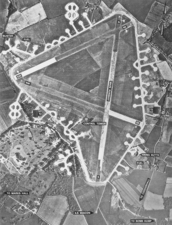
image-width = 300
caption = Postwar RAF aerial photo of Earls Colne Airfield -9 July 1946
IATA =
ICAO = EGSR
type = Public
owner =
operator = Bulldog Aviation Ltd
city-served =Halstead
location =Earls Colne
elevation-f = 227
elevation-m = 69
coordinates = Coord|51|54|52|N|000|40|57|E|type:airport|display=inline
website =
metric-rwy = Y
r1-number = 06/24
r1-length-f = 3,081
r1-length-m = 939
r1-surface =Grass /Asphalt
stat-year =
stat1-header =
stat1-data =
stat2-header =
stat2-data =
footnotes = Source: UK AIP at NATSLocation map
Essex
lat=51.91444
long=0.6825
width=180
float=right
caption="Earls Colne Airfield shown withinEssex " (gbmapping|TL850270)Earls Colne Airfield Airport codes|N/A|EGSR is located 1
nautical mile ("NM") (1.8 km) South-southwest ofEarls Colne and 3 NMs (5.6 km) Southeast ofHalstead inEssex ,England . It is a general aviation airfield also used for pilot training. DuringWorld War II the airfield was used by theRoyal Air Force andUnited States Army Air Force as a base for heavy and medium bombers.Earls Colne Aerodrome has a CAA Ordinary Licence (Number P860) that allows flights for the public transport of passengers or for flying instruction as authorised by the licensee (Bulldog Aviation Limited). [ [http://www.caa.co.uk/docs/375/srg_asd_ordinarylicences.pdf Civil Aviation Authority Aerodrome Ordinary Licences] ]
Origins
The airfield was built to the standard Class A bomber station with a 6.000ft main runway aligned 01-19 and two auxiliaries of 4,200ft aligned 07-25 and 12-30. Like other airfields of the same period, it was originally laid out with 36 pan type hardstandings but, after Earls Colne was allocated for USAAF use on 4 June 1942, an additional 16 loop hardstandings were added, one pan being eliminated in the process. Two dispersed T2 hangars and technical site buildings were erected and accommodation for 2,570 persons was provided on seven dispersed domestic sites.
During construction, an American B-17F (41-24352) of the 301st Bomb Group from
RAF Chelveston made an emergency landing at the unfinished field. Earls Colne was opened in August 1942 and for the first year it was operated by No. 3 Group Bomber Command of the Royal Air Force. Apart from temporary use by F-5 Lightning photographic aircraft as a forward base, and emergency landings by a variety of types returning from operations, Earls Colne remained vacant.USAAF use
In May 1943 the airfield was turned over to the
United States Army Air Force . USAAF groups of the Eighth and Ninth Air Forces used the airfield. It was assigned USAAF designation Station 358, Station Code "EC".From
12 June 1943 through16 October 1943, Earls Colne (along with nearby Marks Hall) served as headquarters for the 3d Combat Bombardment Wing of the 3d Bomb Division.94th Bombardment Group (Heavy)
The first American unit to use Earls Colne was the 94th Bombardment Group (Heavy) moved in with the Boeing B-17 Flying Fortress, arriving from
RAF Bassingbourn on12 May 1943. The group tail code was a "Square-A". Its operational squadrons were:* 331st Bomb Squadron (BG)
* 332d Bomb Squadron (OE)
* 333d Bomb Squadron (ET)
* 410th Bomb Squadron (QW)Its tenure was brief as the Eighth Air Force moved the B-17s into
Suffolk on12 June as the group was moved toRAF Bury St. Edmunds in a general exchange of bases withB-26 Marauder groups.323d Bombardment Group (Medium)
Replacing the 94th at Earls Colne was the 323d Bombardment Group (Medium) which arrived from
RAF Horham on14 June 1943. The group was assigned to the 3d Bomb Wing and flew Martin B-26B/C Marauders with a Horizontal white tail band for its group marking. Operational squadrons of the 323d were:* 453d Bomb Squadron (VT)
* 454th Bomb Squadron (RJ)
* 455th Bomb Squadron (YU)
* 456th Bomb Squadron (WT)The 323rd inaugurated medium-altitude bombing missions on
16 July 1943 and during that summer its principal targets were marshalling yards, airfields, industrial plants, military installations, and other targets inFrance ,Belgium , andHolland .In common with other Marauder units of the 3d Bomb Wing, the 323d was transferred to
Ninth Air Force on16 October 1943. Tactical missions were flown against V-weapon sites along the coast of France and attacked airfields atLeeuwarden andVenlo in conjunction with the Allied campaign against the German Air Force and aircraft industry duringBig Week , 20-25 Feb 1944.The 323d helped to prepare for the invasion of Normandy by bombing coastal defenses, marshalling yards, and airfields in France and struck roads and coastal batteries on
D-Day ,6 June 1944 .On
21 July the group was moved south toRAF Beaulieu inHampshire , a move designed to extend their range over western France.Royal Air Force use
In September 1944 the airfield returned to RAF control, with No. 38 Group bomber station operating the
Armstrong Whitworth Albemarle s andHandley Page Halifax es. 38 Group was used as a glider towing unit (Squadrons Nos. 296 and 297).Both squadrons participated in
Operation Varsity , the airborne part of the Rhine Crossing in March 1945.Postwar use
These squadrons remained at Earls Colne until early in 1946, when the former was disbanded and the other moved out in March. Held on care and maintenance status for a short period, the airfield was soon abandoned and eventually put up for public auction in 1955.
When de-requisitioned in 1955 much of the airfield was returned to agricultural use. In 1965, a large part of the airfield was purchased from an investment company and all available land was initially farmed. The concrete areas were sold to St Ives Sand and Gravel, the company supplying aggregate for foundations of the A12 improvements between September 1965 and February 1967 who removed most of the runways, hardstands and perimeter track.
The T-2 hangar on the technical site - in which Glenn Miller once played was rented for storage and many technical site buildings were used for light engineering firms, the whole of the former technical site becoming an industrial area. The east side hangar has for many years afforded cover for heavy construction machinery.
The control tower was used as a house for many years, eventually being demolished in 2003.
Much of the airfield today is being used as a golf course which was built in the early 1990s that consists of two 18-hole courses, a clubhouse, restaurant and leisure facilities. A flying club also operates from the old airfield, using a grass strip that runs along the line of the former south-west/north-east runway
ee also
*
List of RAF stations
* USAAF Eighth Air Force - World War II
* USAAF Ninth Air Force - World War II
*94th Airlift Wing
*323d Flying Training Wing References
* Freeman, Roger A., "UK Airfields of the Ninth: Then and Now", 1994
* Freeman, Roger A., "Airfields Of The Eighth, Then And Now", 1978
* [http://www.controltowers.co.uk/E/Earls_Colne.htm www.controltowers.co.uk Earls Colne]
* [http://mighty8thaf.preller.us/php/1Loc.php?Base=Earls%20Colne mighty8thaf.preller.us Earls Colne]
* Maurer Maurer, "Air Force Combat Units Of World War II", Office of Air Force History, 1983
* [http://home.att.net/~jbaugher/usafserials.html USAAS-USAAC-USAAF-USAF Aircraft Serial Numbers--1908 to present]External links
* [http://www.anglianflightcentres.co.uk/ Anglian Flight Centres]
* [http://www.ecbp.co.uk/index.htm Earls Colne Business Park]
* [http://www.b26.com/uk_marauder_bases/earls_colne_airfield.htm Earls Colne at /www.b26.com]
* [http://www.geograph.org.uk/gridref/TL8447227438 Photographs of Earls Colne Airfield from the Geograph British Isles project]
Wikimedia Foundation. 2010.