- Aywaille
-
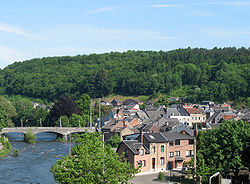
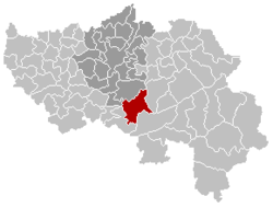
Aywaille The Amblève in Aywaille Location in Belgium Coordinates: 50°28′N 05°40′E / 50.467°N 5.667°E Country Belgium Region Wallonia Community French Community Province Liège Arrondissement Liège Government – Mayor Philippe Dodrimont – Governing party/ies EC Area – Total 79.97 km2 (30.9 sq mi) Population (1 January 2010)[1] – Total 11,460 – Density 143.3/km2 (371.2/sq mi) Postal codes 4920 Area codes 04 Website www.aywaille.be Aywaille is a Belgian municipality located in the Walloon province of Liège. On January 1, 2006 Aywaille had a total population of 10,910. The total area is 79.97 km² which gives a population density of 136 inhabitants per km². The inhabitants of Aywaille are called the "Aqualiens". Aywaille is situated on the river Amblève.
The municipality includes not only Aywaille itself but also the villages of Ernonheid, Harzé and Sougné-Remouchamps.
References
- ^ Population per municipality on 1 January 2010 (XLS; 221 KB)
Municipalities of the Province of Liège Huy 
Liège Verviers Amel · Aubel · Baelen · Büllingen · Burg-Reuland · Bütgenbach · Dison · Eupen · Herve · Jalhay · Kelmis · Lierneux · Limbourg · Lontzen · Malmedy · Olne · Pepinster · Plombières · Raeren · Sankt Vith · Spa · Stavelot · Stoumont · Theux · Thimister-Clermont · Trois-Ponts · Verviers · Waimes · Welkenraedt
Waremme Categories:- Municipalities of Liège
- Liège geography stubs
Wikimedia Foundation. 2010.


